Winter Storm Watch: First snow maps and timeline this weekend
Thursday December 15 - A Winter Storm Watch has been issued for Friday night through Saturday morning. This is for minor snow accumulation plus ice before a change over to

Thursday December 15 - A Winter Storm Watch has been issued for Friday night through Saturday morning. This is for minor snow accumulation plus ice before a change over to

Thursday December 15 - Today will be an opposite day of sorts. The winds will pick up as the temperatures drop down. A Wind Advisory has been issued for today

Sunday December 11 - A Freezing Rain Advisory has been issued to include central Maryland north of Baltimore between midnight and 7 AM on Monday December 12. This will be a

Sunday December 11 - Flurries have arrive. The radar shows it and the atmosphere finally supported the flakes falling and reaching the ground this morning. We have a stickage and

Wednesday November 30 - A Dense Fog Advisory has been extended until 8 AM west of the Chesapeake Bay in Maryland, southern PA, and northern VA. But until 9 AM on

10 PM Tuesday November 29 - A Dense Fog Advisory is in effect for Maryland Counties west of the Chesapeake Bay, southern Pennsylvania, and northern Virginia. The rain today and
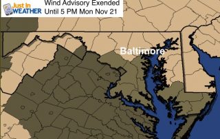
Monday Nov 21 - The strong cold front and upper level Low now in New England responsible for the cold wind over the weekend is still doing its thing. The
Sunday November 20 - The monster cold front we had yesterday meant business and today you will feel the cold winds for sure. Baltimore's BWI went from a high of

Saturday November 19 - A strong cold front is on the way that will mark a significant pattern change. Baltimore hit 73°F on Friday which was not a record but

Saturday November 12 - A clear sky might be deceiving today. High Pressure is in control, but a very cold air mass has settled into the region. The good news