Morning Snow Update Feb 9
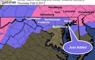
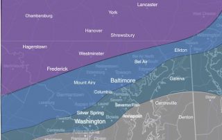
Thursday February 9 - The change over to snow has occurred on schedule but the storm itself is speeding up. The biggest concern this morning is the morning commute as

Thursday February 9 - The change over to snow has occurred on schedule but the storm itself is speeding up. The biggest concern this morning is the morning commute as
February 8th - Light rain has already started to move into the area and the storm we've been talking about all week is about to take form. If you have

Wednesday February 8 - For the second day in a row, temperatures soared well above expectations and scored another record high at Baltimore's BWI. It may seem like Denver weather
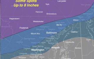
February 8 - The trend for the storm verifying colder is showing more support. Despite temperatures are in the 60s today, the storm tonight will start as rain but turn
February 8 - Temperatures are in the 60s but the storm tonight will start as rain and turn to heavy snow. The intensity will impact travel Thursday morning, but the
February 8 - This morning has temperatures still holding in the lower 60s for Baltimore. It is hard to imagine that in less that 24 hours we will have a
Tuesday February 7 - It does seem hard to believe that after a record day in the 70s we have a snowstorm on the way. Perhaps even hard to imagine

February 7 2017 - As expected, a new record high temperature was set at Baltimore's BWI today just a day and a half ahead of a abrupt return to winter.

Sunday January 29 - A quick moving system will arrive tonight and bring a round of snow for our region. This is a clipper type Low Pressure, that will be

Monday January 23 - We are still under a Wind Advisory and there will be some bands of heavy rain this afternoon. Baltimore's BWI had a top gust of 43