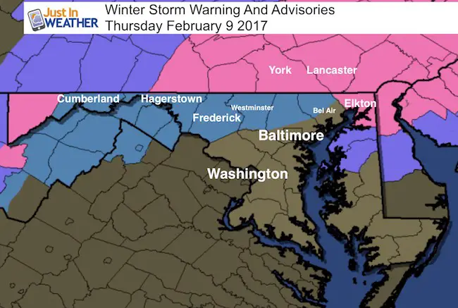
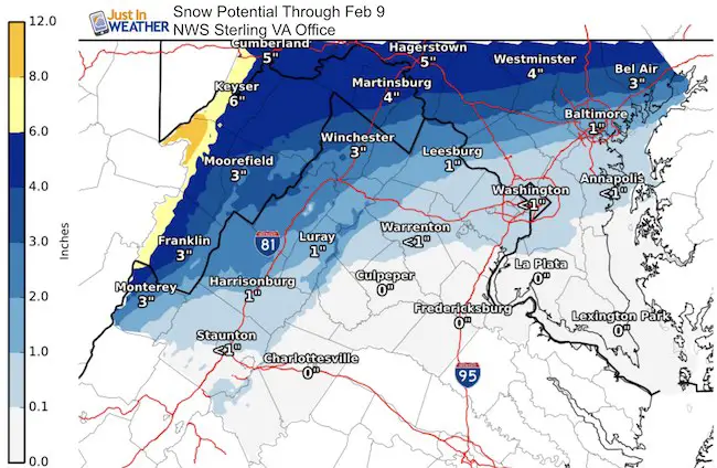
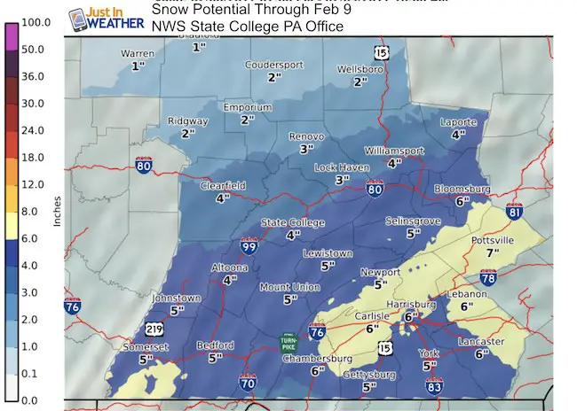
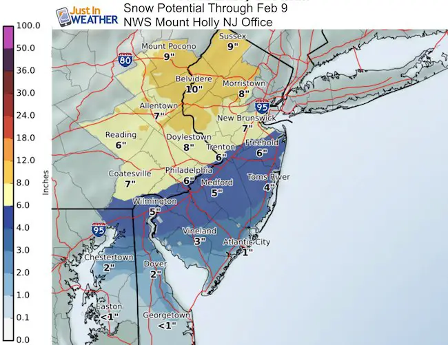
 February 8 – This morning has temperatures still holding in the lower 60s for Baltimore. It is hard to imagine that in less that 24 hours we will have a raging snow storm, but it is looking more likely. In fact the most consistent computer model has trended a little colder, which means a better chance for stickage and accumulation closer to Baltimore for the Thursday morning commute. Farther north, where it will be cold enough to maximum impact, southern Pennsylvania counties have been upgraded to a Winter Storm Warning. This just means we are more confident that there will be more than 4 inches of snow in these areas. York and Lancaster are included, which is in my call for 3 to 6+ inches. This Warning has also been upgraded from the NWS office in Mount Holly, NJ the covers Cecil County in Maryland.
The Winter Storm Watch, and even lack of advisories in north/central Maryland are a result of the National Weather Service Office in Sterling VA. They have not made any adjustments yet, but I expect they will during the day today.Yes, I see an impact for Baltimore and possibly Washington.
Cyclogenesis: Tracking The Rapidly Developing Storm
- This will start as rain this evening and not look like much on the weather maps. But as I mentioned in my prior posts, the storm will be developing rapidly on the southern edge of the jet stream. This is called cyclogenesis.
- The storm will pulse just as it passes to our south, allowing moderate to heavy rain to change over to heavy snow.
- The heavy snow will fall before the air temperatures drop below freezing.
- Snow rates could reach 1 inch or more per hour. That will cool the ground down quickly and allow for stickage.
- Roads will get less than the grass, but should have an impact on travel during the Thursday morning commute.
—-> slider GFS Model
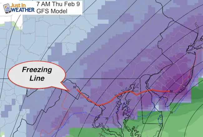
SnapShot: Trending Colder
This 7 AM plot of the GFS Model highlights the freezing line. This is a little farther south than previous runs, meaning the colder air will be wining and more snow can be expected.
 Get the award winning Kid Weather App I made with my oldest son and support our love for science, weather, and technology. Our 3 year anniversary of the release and our contribution to STEM education is this November. It has been downloaded in 60 countries, and works in both temperature scales. With your support we can expand on the fun introduction to science and real weather.
Snow Problems: Stickage And Icing
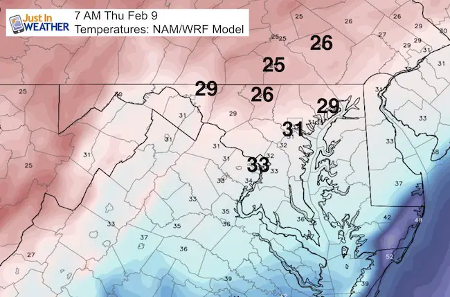
The freezing line temperatures are expected to reach through Baltimore Thursday morning. Along with heavy snow, I-95 could have accumulation at his time.
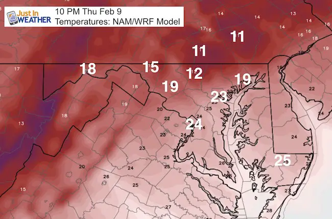
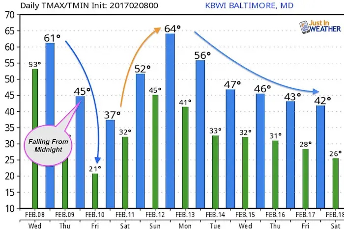
Below Freezing At Night
Look at the temps deep into the lower teens and 20s Thursday night. There will light snow/snow showers in the evening, so salting and maybe some light additional accumulation could require road crews to throw more salt or even push snow.
Snow Forecast
This is my First Call For Snowfall map I showed last night. Compare to the NWS Updated Maps

NWS Forecast Maps: 3 Regional Office Maps
Faith in the Flakes Online- Flannel PJs Printed Inside Out
Store Now Open

- We’ve added Flannel PJ Pants that will be printed inside out. They have to be, to make it snow ?
- Free Personal Delivery for orders of 20 items or more to schools and businesses.
- Click this image for the online store.
- Look for more items to be added soon.
- Also see the info for the STEM Assembly Spirit Wear program: Put your school name on the shirts and raise money for you PTO/PTA in the process.
Temperature Outlook
There will be a quick warm up over the weekend and then a trend back to a colder pattern next week.
Please share your thoughts, best weather pics/video, or just keep in touch via social media
- Facebook: Justin Berk, Meteorologist
- Twitter: @JustinWeather
- Instagram: justinweather
Sign up for email updates on new posts
Since you may miss some posts via social media, click here for email alerts as a way to make sure you don’t miss any. *You may have to refresh that page once for your browser to clear out the images.
FITF SNOW STICKS
 Available in 2 Ft, 30 Inches, and 3 Ft Sizes. Also with Orange/Black or Purple/Black. Click on the image to see the options offered by my friend Thatcher at Signs By Tomorrow in Timonium.
Go to http://www.signsbytomorrow.com/timonium/ to order yours today! Click the ‘Request a Quote’ button at the top of the page. In comment box include color, size and payment information. Please indicate whether you’d like to have us UPS ship them to you or if you would like to pick up in our store. Snow Sticks will ship or will be ready for pick up in our store 48 hrs after order is placed, Mon-Fri.
Also See:
My Winter Outlook for 2016-2017: Colder with snow spread out more
NOAA Winter Outlook for 2016 to 2017
La Nina Formed: What it could mean to our winter
Farmers Almanacs Split On Cold And Snow
Extreme Weather of 2015 balanced out on both ends
Low Snow Winters In Baltimore: Records Might Surprise You