July 28 Weather Flood Watch For Metro DC and Storm Simulaiton Update
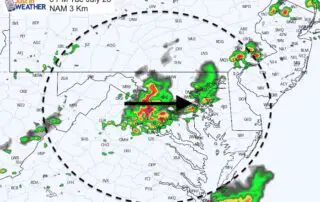
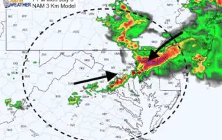
Tuesday July 28 2020 A cold front is beginning to cross our region this afternoon. As a result of interacting with the very warm and humid air, showers and strong

Tuesday July 28 2020 A cold front is beginning to cross our region this afternoon. As a result of interacting with the very warm and humid air, showers and strong
Tuesday July 28 2020 We start off this morning with very warm air, but the the humidity will be the story on the day. Heat Index values will be over
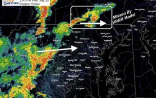
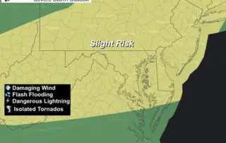
Wednesday July 22 2020 A Sever Thunderstorm Watch has been issued for most of our region through this evening. We have already had warnings issued in PA, western Maryland, and
Wednesday July 22 2020 The storms that crossed the region yesterday provided some relief from the heat, but added to the humidity. You should feel it today and another Heat
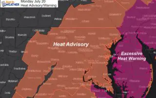
July 20 2020 Today should be the worst of this stretch. Temps will be comparable or a little hotter than yesterday when BWI reached 100ºF. The humidity will make it
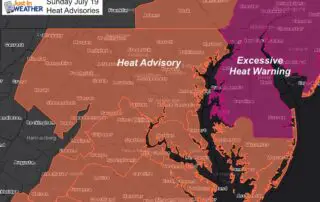
Sunday July 19 2020 The last two days both reached 98ºF in Baltimore at BWI. Similar afternoon heat will remain for at least two more days, but along with higher
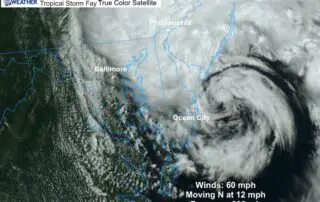
Friday July 10 2020 Tropical Storm Fay has intensified in the 11 AM advisory with winds of 60 mph. It is centered just east of Delaware, where the Tropical Storm
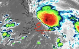
Thursday Evening July 9 2020 Tropical Storm Fay has officially formed today. The winds are a minimal 40 mph and it is nor well organized. The heaviest rain is well
Monday July 6 2020 The atmosphere is primed to dump a lot of rain on some areas today. The high temperatures in the 90s and dew points in the mid

Wednesday June 3 2020 A Severe Thunderstorm Watch has been issued until 3 PM. This follows a cluster of storms in central PA dropping to the southeast. The primary risk