Icy Start With Heavy Rain And Quick Warming This Morning
February 16 5:50 AM Update- The cold definitely held strong overnight. As a result thick ice covers most everything and will be slow to thaw despite the warming this morning.
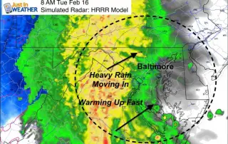
February 16 5:50 AM Update- The cold definitely held strong overnight. As a result thick ice covers most everything and will be slow to thaw despite the warming this morning.
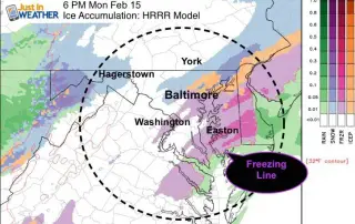
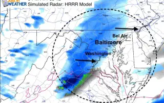
February 15 4:50 PM Update - Snow has changed to freezing rain or sleet in many parts as warmer air advances north at cloud level. The thing is, the ground
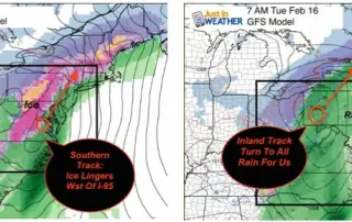
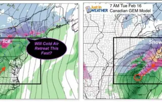
February 15 10:15 AM Update- The cold will hold longer. That has been my suggestion for a few days, and now there is more support to how it. One of
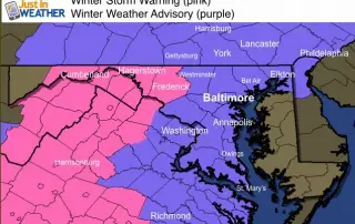
February 14 - A Winter Storm Warning (pink) has been posted for Monday into Tuesday for areas that should remain colder for longer and add ice on top of snow. The
February 14 - Happy Valentines Day. The good news is that we have turned the corner as the coldest of this arctic blast is moving away. With Presidents Day tomorrow,

February 13 - We are in the midst of our coldest days of the season, and still have a Wind Chill Advisory through Sunday. But we must look just past

February 13 - If you have not heard the term Polar Vortex (again) this week, it's back. The core of the coldest air in the Northern Hemisphere is diving towards New
February 12- There will be a lot of weather action on the way over the next 3 to 5 days. As I write this, wind warning an wind chill advisories are
February 11- As we are just getting our preview before the full force arctic blast this weekend, many eyes are already looking beyond to the storm next week. If you

February 9 - There is light snow still falling around the Maryland and Pennsylvania line. Another batch of moisture in southern Maryland has rain mixing over to snow. Only a