April 9 Another Wind Advisory Then Freeze Watch Overnight And Quiet Weekend Warming
Friday April 10 2020 The strong wind may have eased overnight, but it is back today. We are caught between a snow storm in northern New England and High Pressure
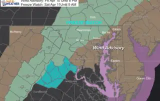
Friday April 10 2020 The strong wind may have eased overnight, but it is back today. We are caught between a snow storm in northern New England and High Pressure

Thursday April 9 2020 I squeezed all I could in the title of this post because we will be squeezing a lot of weather into the next two days. After
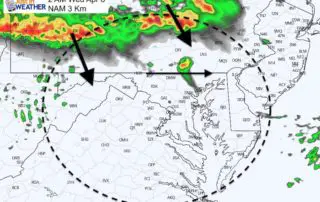
April 8 2020 Did you wake up from the early morning storms? That line we tracked last night did prove to be an overachiever and held up multiple rounds of
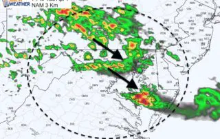
Tuesday Evening Update April 7 2020 Watching a line of storms this evening across the lower Great Lakes, the short range models bring that across southern Pennsylvania and into north
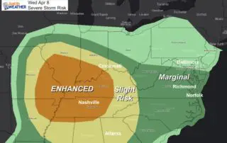
2 PM Tuesday April 7 The Storm Prediction Center has upgraded the severe storm risk to Enhanced for Parts of the Mid West. The primary risk is for large hail
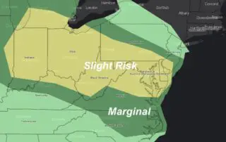
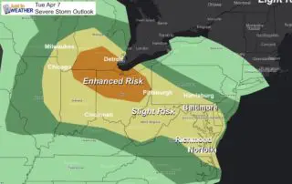
Tuesday April 7 2020 Clouds have filled back in, so this weather will not be as beautiful as yesterday. The Storm Prediction Center has placed our region under a Slight
Monday April 6 2020 Today continues the nice weather we had at the end the weekend. With sunshine, we should reach the mid 60s. But it is spring and often
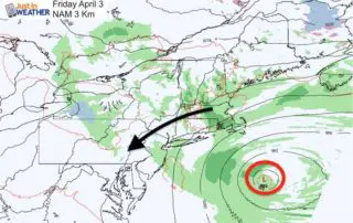
Friday April 3 2020 The winds will be gusty again today, and clouds will make a return as a strong storm off of the coast is retrograding. That means it
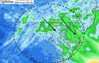
Thursday April 2 2020 We have a couple of more chilly days, and today will definitely feel it with increasing winds. The departing storm off of the coast and new
Wednesday April 1 2020 The same weather pattern that has kept us with clouds and chilly rain, has piled up the winds and water for some parts of the Chesapeake