Thursday July 29 2021
ENHANCED SEVERE STORM RISK TODAY!
This is Level 3 out of 5 for severity! Please take this one seriously! A very charged atmosphere has already had a history of destructive storms in the Great Lakes, and that energy will reach us any time after 4 PM.
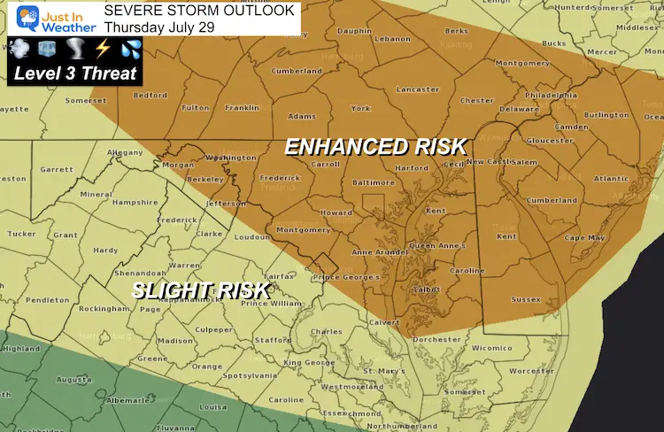
Risk for storms to produce
- Damaging Winds
- Large Hail
- A Few Tornados
- Dangerous Lightning
- Flash Flooding
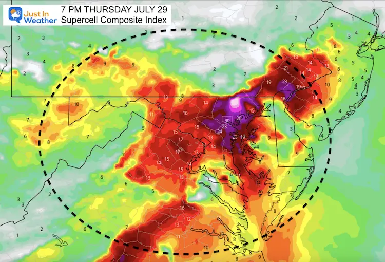
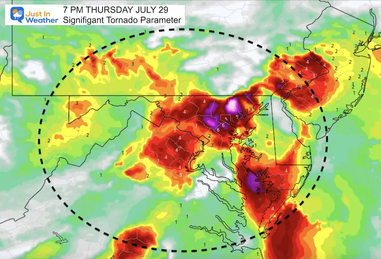
Severe Storm Parameters
These maps may tell the story better than the radar simulation (below). I’ve used the snapshot of 7 PM, which is when the peak of the activity should reach north central Maryland.
Tracking Reminder:
Live Radar/Lightning has already been set up. See the pages labeled for local areas at the bottom of this post.
What is likely to happen:
A Severe Thunderstorm or Tornado Watch may be issued this afternoon and evening. That will cover a large part of our region for 6+ hours. It means severe storms are likely but not promised. This will heighten the anticipation of watch for the rough weather to form.
Severe Thunderstorm or Tornado Warnings may be issued. That will be when a storm with those conditions has formed. This will be tracked through specific towns in a smaller county location. That is when you need to seek shelter.
Supercell Storms:
These are rotating cells that can produce the most severe weather with destructive winds and large hail. The storms themselves rotate, which can produce a tornado, but does not promise that.
Significant Tornado Parameter
This is the likelihood that an actual funnel cloud may form and reach the ground.
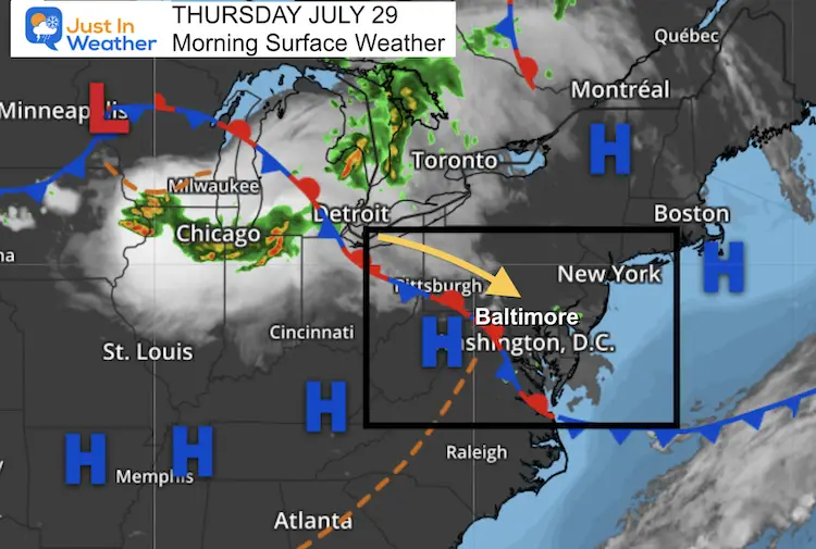
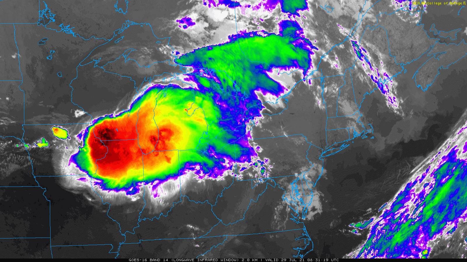
Morning Surface Weather
Low Pressure along a strong cold front has produce what we call a Mesoscale Convective Complex. It is not a derecho, but can behave similarly with large scale coverage of destructive weather.
Satellite Loop
2 Hour Loop from 4:30 AM to 6:30 AM
This system is fading this morning, but will re-energize with the heat of the day. It is expected to reach our region when it hit maximum potential later today.
Radar Simulation —->slider
Reminder: This product is not perfect. It has underplayed storms all summer.
This still shows the development between 2 PM and 4 PM, that we will watch pass through central Maryland and southern PA with multiple storm cells any tine from 4 PM to midnight.


Weather Almanac: Climate Data
TODAY July 29
Normal Low in Baltimore: 67ºF
Record 59ºF in 2014
Normal High in Baltimore: 87ºF
Record 101º F 2011
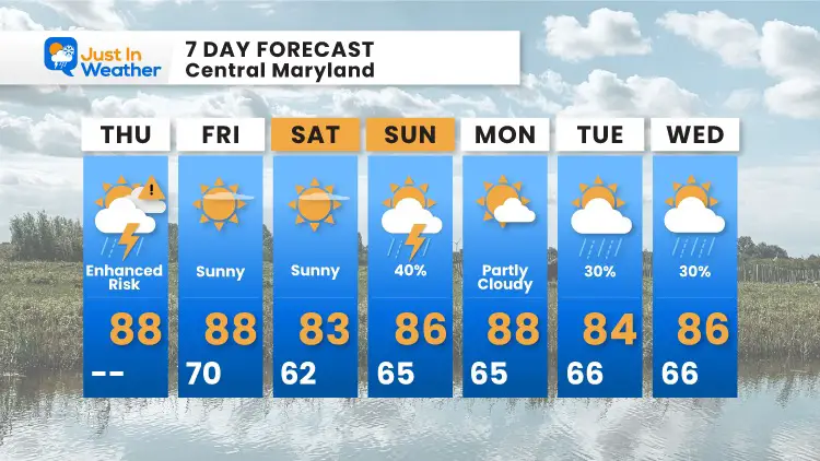
7 Day Forecast
A big improvement begins tomorrow, then much cooler and more comfortable this weekend into next week.
Maryland Trek 8 Begins on August 8
329 Miles From Wisp To Ocean City
To Honor Kids In Cancer Treatment and Support FREE Programs At Just In Power Kids
![]()
Sunshine State Of Mind
I am done with the cold and snow (for the season). I am embracing my wife’s mantra of Sunshine State of Mind.
This was designed by Shannon Berk and we will be wearing it through spring and to the beach.
Double Benefit: Proceeds will be split between our nonprofit Just In Power Kids and the development of my new weather website. That has been scheduled to be ready to launch in May.

14 Local Maryland Pages (and York PA)
We have made a page for Maryland Weather which gives you the current conditions for 14 present area locations.

Please share your thoughts, best weather pics/video, or just keep in touch via social media
Facebook: Justin Berk, Meteorologist
Twitter: @JustinWeather
Instagram: justinweather