Tuesday July 6 2021
Tropical Storm Elsa is passing west of Key West Florida this morning. Most of the activity is on the east side of the storm center, and there has been a flare up this morning suggesting there is a chance it can intensity to Hurricane strength before making landfall tonight.
Tropical Storm Force Winds (over 40 mph) reach 70 miles from the center. Waves and rain reach much farther away.
The forward movement has slowed to 10 mph. That will allow this to stay over water longer, which would encourage strengthening.
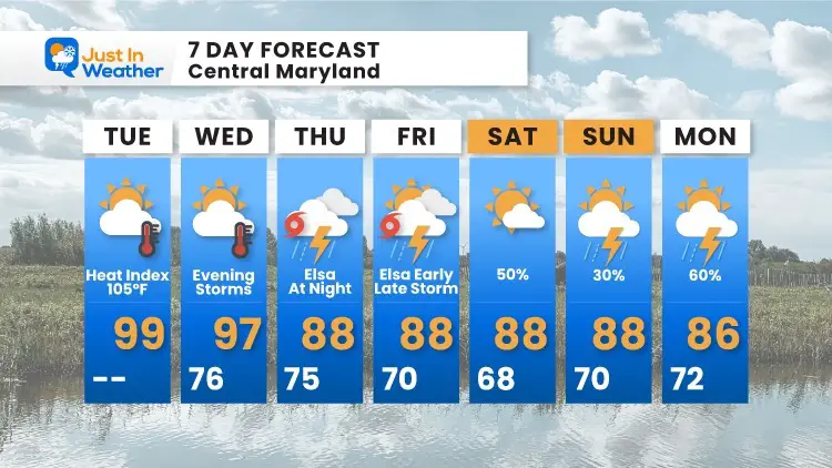
If you are vacationing on the beaches of the Mid Atlantic, the impact from Virginia Beach through Ocean City, Maryland and Delaware will be felt late Thursday into Friday.
Morning Snapshot
This will track inland across north Florida overnight. Then it is forecast to head back over the ocean very close to Ocean City Maryland overnight Thursday into Friday before sunrise.
See the track and interactive wind forecast maps below.

Closer Satellite Loop
This starts at sunrise and the flare up of convection showing intensification of TS Elsa.

National Hurricane Center Update
SUMMARY OF 1100 AM EDT
———————————————–
LOCATION…24.9N 82.8W
ABOUT 65 MI…105 KM WNW OF KEY WEST FLORIDA
ABOUT 215 MI…345 KM S OF TAMPA FLORIDA
MAXIMUM SUSTAINED WINDS…60 MPH…95 KM/H
PRESENT MOVEMENT…NNW OR 340 DEGREES AT 10 MPH…17 KM/H
MINIMUM CENTRAL PRESSURE…1007 MB…29.74 INCHES
Florida Landfall Track
Here is the National Weather Service forecast track and cone of uncertainly along the Florida Gulf Coast today.
Tropical Storm Warnings are in place, but a Hurricane Watch has been added on top north of Tampa. This is for the potential for winds to reach 75 mph by tonight.

Closer Look: North Florida
The latest expectation is for the center to make landfall north of Clearwater, possibly Cedar Key early Wednesday morning. However, metro Tampa will be on the stronger east side of the storm overnight.

SUMMARY OF WATCHES AND WARNINGS IN EFFECT:
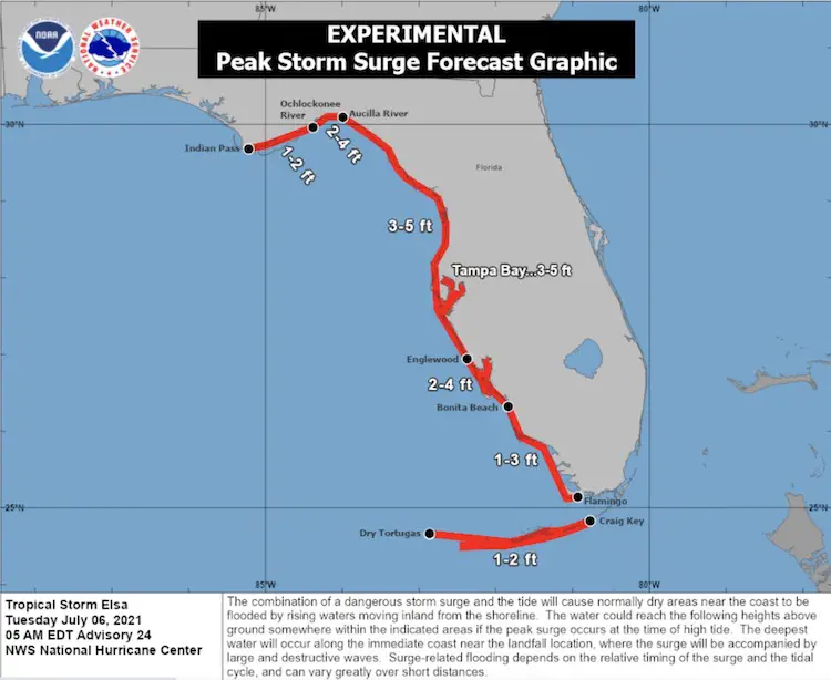
A Storm Surge Warning is in effect for…
* West coast of Florida from Bonita Beach to the Aucilla
River, including Tampa Bay
A Tropical Storm Warning is in effect for…
* The Cuban provinces of Matanzas, Mayabeque, Havana, and Artemisa
* The Florida Keys from Craig Key westward to the Dry Tortugas
* West coast of Florida from Flamingo northward to Ochlockonee River
A Hurricane Watch is in effect for…
* Egmont Key to the Steinhatchee River, Florida
A Storm Surge Watch is in effect for…
* West of the Aucilla River to the Ochlockonee River, Florida
A Tropical Storm Watch is in effect for…
* West of the Ochlockonee River to Indian Pass, Florida
* Mouth of St. Marys River to South Santee River, South Carolina
Closer Look: Mid Atlantic Exit
Any tropical system has the potential for embedded tornadoes.
Sustained winds may be 40 to 50 mph with higher gusts.
Close pass to Ocean City will be within a few hours (before or after) Thursday midnight into Friday morning.
Note: The storm may exit early Friday, but waves will remain turbulent all day.

Wind Forecast Widget
*pinch map to zoom in closer.
ECMWF Model Timeline
Forecast —> slider


Forecast Rainfall
The heaviest rain will be along the coast. However, the push of tropical moisture will interact with a front to the north and higher terrain. Some heavier bands of rain and severe storms may indirectly hit inland.

Extended Forecast
Sunshine State Of Mind
I am done with the cold and snow (for the season). I am embracing my wife’s mantra of Sunshine State of Mind.
This was designed by Shannon Berk and we will be wearing it through spring and to the beach.
Double Benefit: Proceeds will be split between our nonprofit Just In Power Kids and the development of my new weather website. That has been scheduled to be ready to launch in May.

14 Local Maryland Pages (and York PA)
We have made a page for Maryland Weather which gives you the current conditions for 14 present area locations.

Please share your thoughts, best weather pics/video, or just keep in touch via social media