This might be best known as a sleet storm, and it was the most many in our area have ever seen. I said this would be the largest impact storm of the winter and it lived up to it, just not the way I fully expected.
Baltimore at BWI recorded 0.58″ liquid equivalent for the two day storm between February 18 and 19. If that was all typical snow, it would have been nearly 6 inches. If just the first 3 hours were the fluffy snow I mentioned, it would have easily surpassed expectations. However, it was sleet that dominated for many. It added up to an inch or more, which is quite rare and not easy forecast!
I have to give credit to one person who first identified this was going to be more sleet at the start. I’ll show you in a moment.
Regional Snow From NWS Spotters for the Sterling VA Office
Below Please compare My Final Call forecast to the local County Maps and log your grade for my forecast.
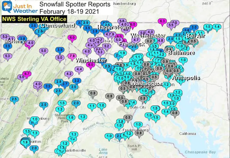
The night before this storm began I made a big point to highlight the initial surge of moisture and the cold temperatures that would lead to higher ratios. I still stand by that, and that actually happened! Heavy snow was reported within minutes of if beginning. Westminster was an example where they had 3 inches of snow in the first 90 minutes. That snow was fluffy and didn’t pack well. But it didn’t last, and they spend much of Thursday morning after sunrise switching back and forth from sleet to snow.
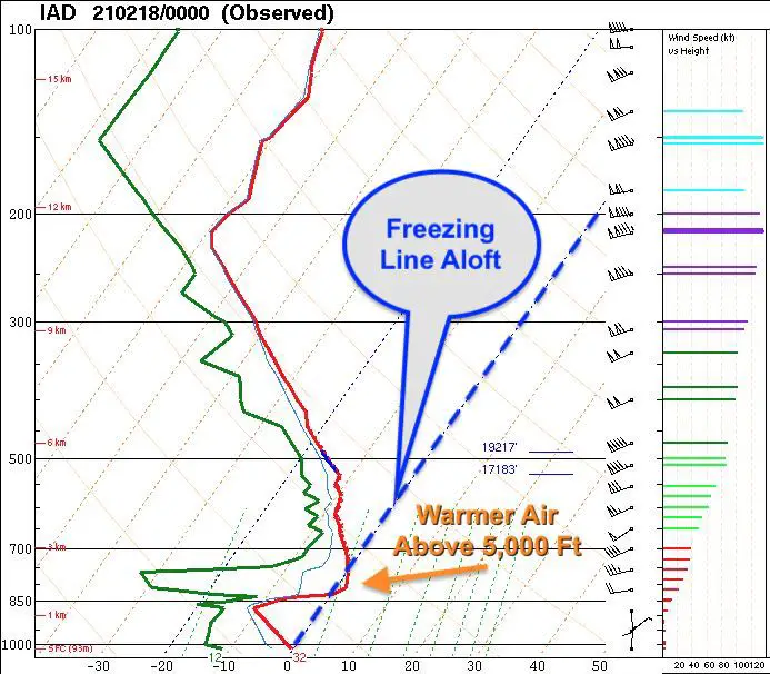
The layer of warm air in the atmosphere around 5,000 Ft up was what melted the snowflakes, then they refroze below on the way down, resulting in heavy sleet. This became evident as it began in metro Baltimore.
Who got that right?
My buddy and long lost Big Brother Tony Pann saw this shaping up the night before it began.
From LWX: “00Z IAD sounding showed a warm nose of 1.8C at the 809 mb level.” What does that mean? Change over to sleet might be quicker, unless the dry air that’s in place can trigger enough cooling at that level to support more snow. I know, it’s all Greek to me too. 😉❄️🚂
— Tony Pann (@TonyPannWBAL) February 18, 2021
I didn’t want to give full credit to that sounding. First, it was over Sterling, VA and I felt central Maryland was deeper into the cold air.
I did show it in my morning report when I announced I was wrong as the storm began. I really had expected the dry air to let the storm dynamically cool that layer and work it out.
SOUNDINGS
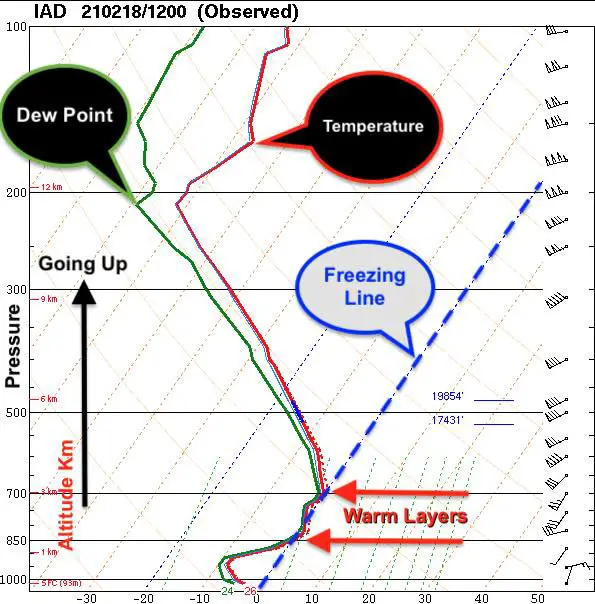
Plotting weather conditions from weather balloon launches twice a day. IAD is the code fro Sterling, VA. This is the home of the National Weather Service Office by Dulles Airport.
Wednesday Night 7 PM (00Z)
Thursday Morning 7 AM (12Z)
This is one of those times where I clearly state my expectations with realization were I was wrong. What you see is how you might grade me, but considering the entirety of the storm, there was still a lot that went right. If you prepared for snow and a lot of ice over two days, then it paid off.
Storm Surface Maps —-> slider


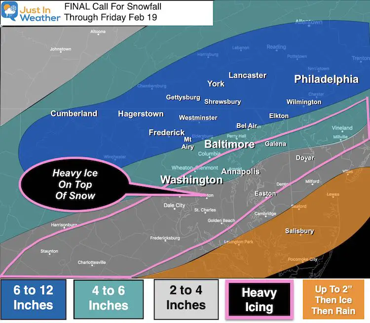
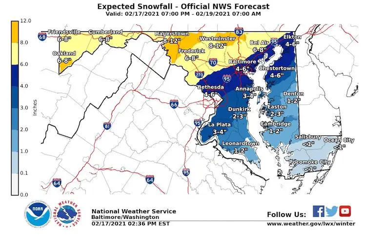
My Final Call For Snowfall
- My Heavy Ice Zone was spot on, but needed to be expanded farther north,.
- Many in my 6″ to 12″ high zone hit or got close to 6″. I did overplay this north of York.
- Elkton, Bel Air, to Mt. Airy was on the edge of my 4″ to 6″. The location of the word might be deceptive.
- Washington and Annapolis: I put them on the edge of 2″ to 4″ on purpose. The location of the word might be deceptive.
NWS Final Call For Snowfall
I wanted to show you that I had a lower end to my ranges for most of Maryland than NWS showed here the night before. hestomrm hit.
What went right With My Forecast:
- Two Days and Two Part Storm
- Lots of Ice On Top Of Snow
- Results in ‘Parts’ of central and western Maryland, Southern Maryland and Delmarva
What Went Wrong With My Forecast:
- The faster change to sleet and freezing rain. I mentioned this right as it began in my Thursday morning report. I said I was wrong, but it was too late for many who wanted to measure more snow.
- I was even wrong reporting I was wrong, because the storm was still producing snow in the colder northern suburbs and Southern PA. But just barely at the 6 inch mark. Also, southern areas got what was expected with ice, and ending with some snow.
- Results: Central/Metro areas I had 4” to 6” but ended up 1” to 3”
- Results in northern Maryland and Southern PA: I had 6” to 12”, many hit the 6” mark… so you can mark that as a win, but it barely got there.
Grade My Forecast
C <—– My grade for my work.
The Sleet Vs Snow was a big deal, but the extent of this storm, plus the accuracy in the northern and southern/eastern areas helped salvage this.
If you grade based on just snow totals, then this adds to a growing list of failed storms from Kent Island To Cecil County. I hear you loud and clear!
Please enter your honest grade for my forecast. See the local maps and spotter reports below.
Polling/Grading Open Until 11:59 PM Sun Feb 21
Local Snow Spotter Maps And Reports
Northeast Maryland: Harford and Cecil Counties
My Forecast Zones: Low End 4″ High End 12″
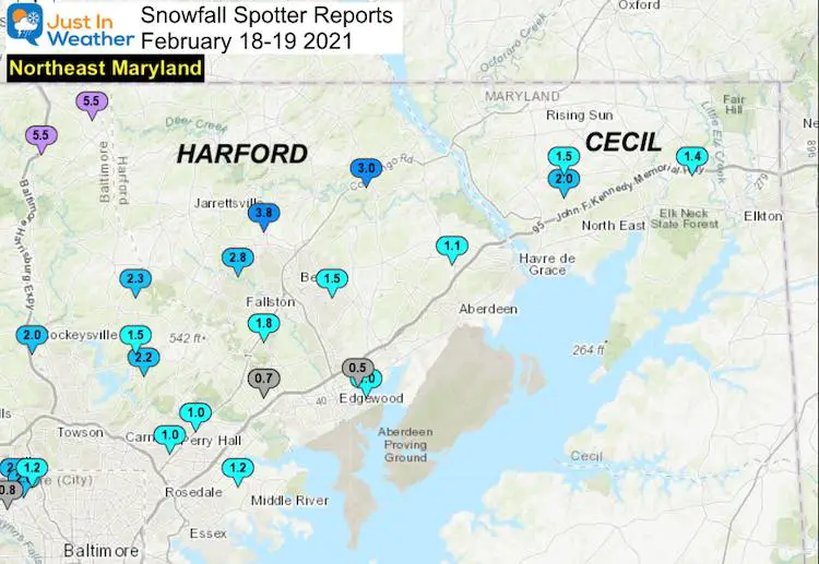
…Harford County…
Forest Hill 1 NNW 3.8 420 PM 2/18 Trained Spotter
Scarboro 2 E 3.0 837 PM 2/18 Trained Spotter
Forest Hill 3 SW 2.8 800 PM 2/18 Trained Spotter
Fallston 2 ESE 1.8 800 AM 2/19 CoCoRaHS
Bel Air 2 E 1.5 1100 PM 2/18 Trained Spotter
Havre De Grace 4 WNW 1.1 1000 AM 2/18 CoCoRaHS
Abingdon 1 SE 1.0 124 PM 2/18 Trained Spotter
Abingdon 0.5 1110 AM 2/18 Trained Spotter
…Cecil County…
Woodlawn 2 E 2.0 130 PM 2/18 Trained Spotter
Woodlawn 2 ENE 1.5 140 PM 2/18 Trained Spotter
Elkton 5 NW 1.4 700 AM 2/19 CoCoRaHS
Baltimore County/City
My Forecast Zones: Low End 4″ High End 12″
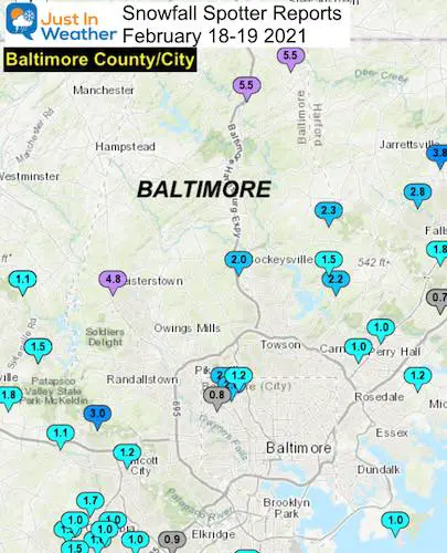
…Baltimore County…
Norrisville 3 W 5.5 100 PM 2/18 Trained Spotter
Bentley Springs 1 E 5.5 1130 AM 2/18 Trained Spotter
Reisterstown 1 NW 4.8 700 PM 2/18 CoCoRaHS
Pimlico 1 NW 2.8 910 PM 2/18 Trained Spotter
Jacksonville 2 NE 2.3 858 AM 2/19 CoCoRaHS
Long Green 1 SW 2.2 700 AM 2/19 CoCoRaHS
Cockeysville 2 WNW 2.0 1203 PM 2/18 Broadcast Media
Long Green 2 NW 1.5 1230 PM 2/18 Trained Spotter
White Marsh 2 ESE 1.2 700 AM 2/19 CoCoRaHS
Perry Hall 1 NNE 1.0 345 PM 2/18 Trained Spotter
Edgemere ESE 1.0 1124 AM 2/19 Trained Spotter
Perry Hall 1 SW 1.0 1135 AM 2/18 Trained Spotter
Upper Falls 1 NNE 0.7 1230 PM 2/18 Trained Spotter
Kingsville 1 E 0.7 700 AM 2/19 CoCoRaHS
…Baltimore City…
Pimlico SE 2.0 200 PM 2/18 Trained Spotter
Mount Washington 1 N 1.2 750 AM 2/19 CoCoRaHS
Arlington 1 NNW 0.8 707 PM 2/18 Trained Spotter
North Central Maryland: Frederick and Carroll Counties
My Forecast Zones: Low End 6″ High End 12″
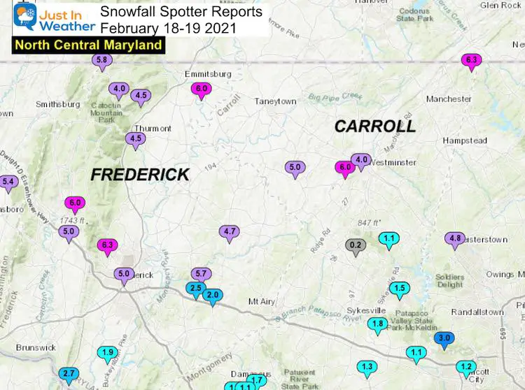
…Frederick County…
Bloomfield 2 WSW 6.3 1100 AM 2/18 NWS Employee
Emmitsburg 2 SE 6.0 615 AM 2/19 Co-Op Observer
Myersville 2 ENE 6.0 1125 AM 2/18 Trained Spotter
Sabillasville 1 NNW 5.8 1130 AM 2/18 CoCoRaHS
New Market 3 NNW 5.7 730 AM 2/19 CoCoRaHS
Frederick 1 SW 5.0 830 AM 2/19 CoCoRaHS
Myersville 2 SE 5.0 1100 AM 2/18 Trained Spotter
Union Bridge 7 SSW 4.7 700 AM 2/19 CoCoRaHS
Thurmont 1 SSE 4.5 1000 AM 2/18 CoCoRaHS
Thurmont 3 N 4.5 700 AM 2/19 CoCoRaHS
Sabillasville 2 SSE 4.0 900 AM 2/19 Trained Spotter
Point of Rocks 1 NE 2.7 100 PM 2/18 Trained Spotter
New Market 2 NW 2.5 900 AM 2/19 CoCoRaHS
New Market N 2.0 320 PM 2/18 Trained Spotter
Adamstown 1 ESE 1.9 100 PM 2/18 NWS Employee
…Carroll County…
Millers 4 NE 6.3 600 PM 2/18 Co-Op Observer
Wagners Mill 1 ENE 6.0 1210 PM 2/18 Trained Spotter
Uniontown 2 S 5.0 941 AM 2/19 Trained Spotter
Westminster SE 4.0 1230 PM 2/18 Trained Spotter
Eldersburg 1 SE 1.5 700 AM 2/19 Trained Spotter
Eldersburg 1 E 1.5 700 AM 2/19 CoCoRaHS
Gamber 1 WNW 1.1 1200 AM 2/19 CoCoRaHS
Gamber 1 W 1.1 700 AM 2/19 CoCoRaHS
Sykesville 6 NNW 0.2 800 AM 2/19 CoCoRaHS
Western Maryland: Garrett, Allegany, and Washington Counties
My Forecast Zones: Low End 4″ High End 12″
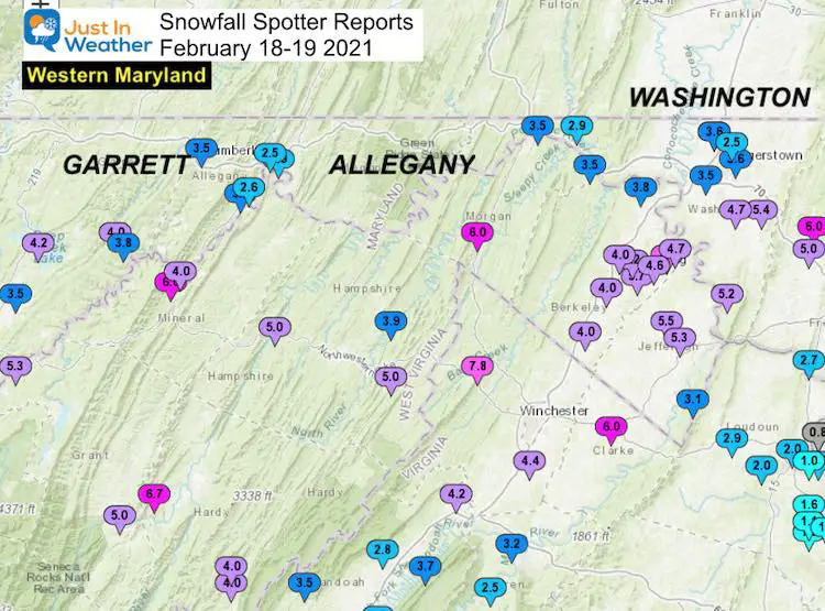
…Garrett County…
Mc Henry 4 SW 5.2 600 AM 2/19 Co-Op Observer
McHenry 5 SSE 4.2 800 AM 2/19 CoCoRaHS
Warnocks 4 NW 4.0 700 AM 2/19 HADS
Bloomington 3 WNW 3.8 200 PM 2/18 Trained Spotter
Mountain Lake Park 3.5 600 AM 2/19 CoCoRaHS
..Allegany County…
Cresaptown-Bel Air 1 3.8 700 AM 2/19 CoCoRaHS
Frostburg 3.5 700 AM 2/19 Co-Op Observer
Cumberland 2.9 700 AM 2/19 Co-Op Observer
Cresaptown SSW 2.6 1045 AM 2/18 Trained Spotter
Ridgeley 1 NW 2.5 427 PM 2/18 Trained Spotter
…Washington County…
Boonsboro 3 NNE 5.4 600 AM 2/19 Trained Spotter
Sharpsburg 5 S 5.2 700 AM 2/19 Co-Op Observer
Fairplay 3 ENE 4.7 530 PM 2/18 Trained Spotter
Long Meadow 2 W 3.6 700 AM 2/19 Trained Spotter
Hagerstown 4 NNW 3.6 700 AM 2/19 CoCoRaHS
Hagerstown 1 ENE 3.6 700 AM 2/19 CoCoRaHS
Hancock 1 ESE 3.5 700 AM 2/19 CoCoRaHS
Williamsport 3 ENE 3.5 600 AM 2/19 CoCoRaHS
Pecktonville 3 NNW 2.9 700 AM 2/19 NWS Employee
Long Meadow 1 SSE 2.5 110 PM 2/18 Trained Spotter
Capital Region: Montgomery, Howard, and Washington DC
My Forecast Zones: Low End 2″ High End 6″ Also: Heavy Ice On Top Of Snow
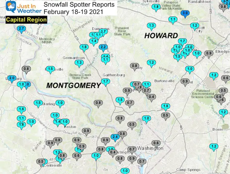
…Montgomery County…
Laytonsville 2 WNW 2.2 727 PM 2/18 Trained Spotter
Clarksburg 1 SSE 1.8 1200 AM 2/19 CoCoRaHS
Laytonsville 5 NNW 1.7 700 AM 2/19 CoCoRaHS
Rockville 3 NNW 1.7 100 PM 2/18 NWS Employee
Poolesville NE 1.5 315 PM 2/18 Trained Spotter
Garrett Park 2 NW 1.5 400 PM 2/18 Trained Spotter
Damascus 3 SSW 1.5 700 AM 2/19 Co-Op Observer
Montgomery Village 1 1.4 630 AM 2/19 CoCoRaHS
Germantown 5 NNE 1.4 600 AM 2/19 CoCoRaHS
Germantown 2 WSW 1.3 1230 PM 2/18 Trained Spotter
Gaithersburg 3 NE 1.1 700 AM 2/19 CoCoRaHS
Colesville 1 NNW 1.1 800 AM 2/19 CoCoRaHS
Norbeck 1 ESE 1.1 700 AM 2/19 CoCoRaHS
Damascus 1 S 1.1 1233 PM 2/18 Trained Spotter
Takoma Park 1 NNW 1.0 700 AM 2/19 CoCoRaHS
Aspen Hill 1 SW 0.9 730 AM 2/19 Trained Spotter
Leesburg 4 NE 0.8 130 PM 2/18 Trained Spotter
Bethesda 0.8 112 PM 2/18 County Emrg Mgmt
Potomac 1 NNW 0.8 700 AM 2/19 CoCoRaHS
Dickerson 7 SW 0.8 730 AM 2/19 CoCoRaHS
Olney 1 ENE 0.8 630 AM 2/19 CoCoRaHS
Colesville 2 W 0.8 700 AM 2/19 CoCoRaHS
Garrett Park 1 ENE 0.7 1100 AM 2/18 Trained Spotter
Rossmoor 1 ESE 0.7 700 AM 2/19 CoCoRaHS
Silver Spring 6 NNE 0.7 546 AM 2/19 CoCoRaHS
Somerset 1 ENE 0.5 117 PM 2/18 Trained Spotter
White Oak 1 N 0.4 700 AM 2/19 CoCoRaHS
…Howard County…
Granite 1 SSE 3.0 100 PM 2/18 Trained Spotter
Sykesville 2 SSE 1.8 700 AM 2/19 CoCoRaHS
Columbia 2 N 1.7 700 AM 2/19 CoCoRaHS
Simpsonville 2 NNW 1.5 647 PM 2/18 Trained Spotter
Simpsonville E 1.5 500 PM 2/18 Trained Spotter
Glenelg 2 N 1.3 1200 PM 2/19 Trained Spotter
Brinklow 1 ENE 1.2 1138 AM 2/18 Trained Spotter
Oella 1 NW 1.2 1130 AM 2/18 Trained Spotter
Marriottsville 3 S 1.1 700 AM 2/19 CoCoRaHS
Columbia 1.0 1230 PM 2/18 NWS Employee
Columbia 2 NE 1.0 300 PM 2/18 Trained Spotter
Columbia 2 NW 1.0 100 PM 2/18 Trained Spotter
Columbia 1 NE 1.0 215 PM 2/18 Trained Spotter
Elkridge 2 W 1.0 1115 AM 2/18 Trained Spotter
Savage 1 N 1.0 1200 PM 2/18 Trained Spotter
Laurel 1 NNE 0.9 700 AM 2/19 CoCoRaHS
Elkridge 0.9 1230 PM 2/18 NWS Employee
…District of Columbia…
Dalecarlia Reservoir 0.8 800 AM 2/19 Co-Op Observer
National Arboretum 0.6 800 AM 2/19 Co-Op Observer
Anne Arundel County
My Forecast Zones: Low End 2″ High End 6″ Also: Heavy Ice On Top Of Snow
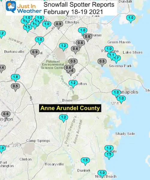
Pasadena 3 ESE 1.7 800 AM 2/19 CoCoRaHS
Deale 1 SE 1.5 700 AM 2/19 CoCoRaHS
Churchton ENE 1.2 105 PM 2/18 Trained Spotter
Crofton 2 NNE 1.2 1200 PM 2/18 NWS Employee
Severn 2 W 1.2 700 AM 2/19 CoCoRaHS
Chelsea Beach 1.1 1200 PM 2/18 Trained Spotter
Bwi Airport 1.0 100 PM 2/19 Airport
Pasadena 1 ENE 1.0 242 PM 2/18 Trained Spotter
Annapolis 1 NNW 1.0 1100 AM 2/18 Trained Spotter
Annapolis 1 SE 1.0 750 AM 2/19 CoCoRaHS
Odenton 1 S 0.6 459 PM 2/18 Trained Spotter
Glen Burnie 1 WSW 0.6 300 PM 2/18 Trained Spotter
Severn 1 SSE 0.6 700 AM 2/19 CoCoRaHS
Severn 2 E 0.6 810 AM 2/19 CoCoRaHS
Odenton 1 WNW 0.6 447 PM 2/18 Trained Spotter
Odenton 1 N 0.5 730 AM 2/19 CoCoRaHS
Severna Park 0.5 130 PM 2/18 Trained Spotter
Southern Maryland
My Forecast Zones: Low End 2″ High End 4″ Also: Heavy Ice On Top Of Snow
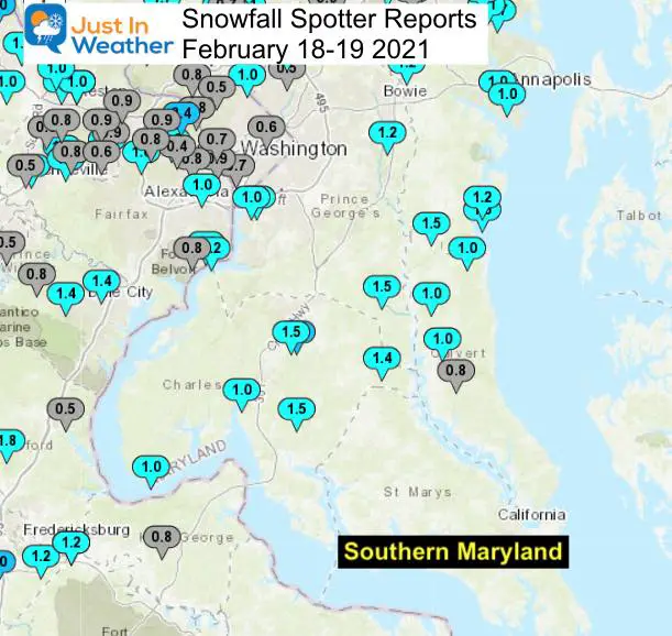
…Calvert County…
Tracys Landing 2 WSW 1.5 1201 PM 2/18 Trained Spotter
Huntingtown 3 SSW 1.0 300 PM 2/18 Trained Spotter
Huntingtown 3 NNW 1.0 700 AM 2/19 CoCoRaHS
North Beach 2 WNW 1.0 730 AM 2/19 CoCoRaHS
Prince Frederick 1 S 0.8 1120 AM 2/18 Trained Spotter
…Charles County…
Waldorf 3 S 2.4 800 AM 2/19 CoCoRaHS
Dentsville 1 SW 1.5 1130 AM 2/18 Trained Spotter
St. Charles 1 SSE 1.5 1120 AM 2/18 Trained Spotter
Hughesville 2 ENE 1.4 1140 AM 2/19 Trained Spotter
Nanjemoy 5 S 1.0 300 PM 2/18 CoCoRaHS
Port Tobacco Village 1.0 700 PM 2/18 CoCoRaHS
…Prince Georges County…
Beltsville 1 SW 1.8 800 AM 2/19 Co-Op Observer
Brandywine 7 ESE 1.5 700 AM 2/19 CoCoRaHS
Bowie 4 S 1.2 700 AM 2/19 CoCoRaHS
Oxon Hill 1 SW 1.0 800 AM 2/19 Co-Op Observer
Oxon Hill 1 W 1.0 800 AM 2/19 CoCoRaHS
College Park 1 ENE 0.5 500 PM 2/18 Trained Spotter
Southern Pennsylvania
My Forecast Zones: Low End 6″ High End 12″
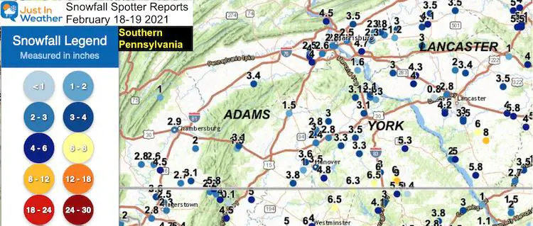
…York County…
Stewartstown 0.5 S 9.0 in 0700 AM 02/19 COCORAHS
New Freedom 6.5 in 1100 AM 02/18 Public
Shrewsbury 6.0 in 1240 PM 02/18 Public
1 NE Felton 5.3 in 0100 PM 02/18 Public
2 SE Parkville 4.8 in 0130 PM 02/18 Trained Spotter
New Salem 3.5 in 1120 AM 02/18 Trained Spotter
Spring Grove 3.3 in 0203 PM 02/18 Trained Spotter
Manchester 3.1 in 1110 AM 02/18 Trained Spotter
Manchester 3.6 W 3.1 in 0700 AM 02/19 COCORAHS
York 2.5 NNW 3.1 in 0700 AM 02/19 COCORAHS
Dover 4.2 WSW 3.0 in 0445 AM 02/19 COCORAHS
East Berlin 3.4 ESE 2.8 in 0600 AM 02/19 COCORAHS
…Lancaster County…
Quarryville 8.0 in 0200 PM 02/18 Public
3 E Smithville 6.0 in 1100 AM 02/18 Public
2 WNW Wakefield 5.8 in 1215 PM 02/18 Public
Gap 5.8 in 0404 PM 02/18 Trained Spotter
2 NNE Mount Joy 4.3 in 1109 AM 02/18
Millersville 4.2 in 1232 PM 02/18 Trained Spotter
Mount Joy 4.0 in 1230 PM 02/18 Public
New Holland 3.5 in 1015 AM 02/18 CO-OP Observer
1 S Willow Street 3.5 in 1047 AM 02/18 Trained Spotter
1 W Rothsville 3.4 in 1245 PM 02/18 Public
Delmarva
My Forecast Zones: Low End UP TO 2″ High End 6″ Also: Heavy Ice On Top Of Snow
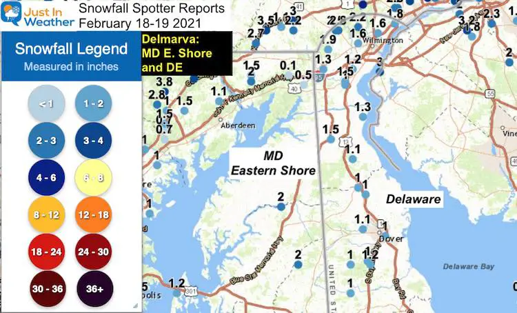
…Maryland…
…Caroline County…
4 SSE Ingleside 2.0 in 1245 PM 02/18 Trained Spotter
…Queen Annes County…
Crumpton 2.0 in 0324 PM 02/18 Public
2 SW Stevensville 1.2 in 0700 AM 02/19 CO-OP Observer
…Delaware…
…Kent County…
1 SSE Woodside 1.2 in 0115 PM 02/18 Trained Spotter
West Dover 1.1 in 0230 PM 02/19 Mesonet
4 S Hazlettville 1.0 in 0230 PM 02/19 Mesonet
1 ESE Dover 1.0 in 0230 PM 02/19 Mesonet
2 S Smyrna Landing 1.0 in 0230 PM 02/19 Mesonet
4 SW Felton 1.0 in 0345 PM 02/18 Public
Smyrna 1.0 in 1250 PM 02/18 Public
Woodside 1.0 in 1212 PM 02/18 Trained Spotter
1 S Harrington 0.7 in 0230 PM 02/19 Mesonet
2 SE Frederica 0.5 in 0230 PM 02/19 Mesonet
…New Castle County…
Bellefonte 2.9 in 0506 AM 02/19 Public
Hockessin 2.5 in 0230 PM 02/19 Mesonet
Winterthur 2.2 in 0230 PM 02/19 Mesonet
White Clay Creek 1.9 in 0230 PM 02/19 Mesonet
1 E Ashbourne Hills 1.8 in 0230 PM 02/19 Mesonet
Monroe Park 1.6 in 0230 PM 02/19 Mesonet
1 SW West Park 1.6 in 0230 PM 02/19 Mesonet
New Castle County Airport 1.5 in 0100 PM 02/19 ASOS
Middletown 1.5 in 0915 AM 02/19 Trained Spotter
1 WNW Port Penn 1.3 in 0230 PM 02/19 Mesonet
1 SSE Newark 1.3 in 0230 PM 02/19 Mesonet
1 E Glasgow 1.2 in 0230 PM 02/19 Mesonet
1 NW Midvale 1.2 in 0230 PM 02/19 Mesonet
2 NE Blackbird 1.1 in 0230 PM 02/19 Mesonet
Bear 1.0 in 0308 PM 02/18 Public
Please share your thoughts, best weather pics/video, or just keep in touch via social media
Facebook: Justin Berk, Meteorologist
Twitter: @JustinWeather
Instagram: justinweather
14 Local Maryland Pages (and York PA)
We have made a page for Maryland Weather which gives you the current conditions for 14 present area locations.

Winter Outlook Series


FITF Shop Open
My ‘bonus’ daughter Jaiden and wife showing off our popular Maryland Hoodies. Unisex and women’s items all produced in Maryland.
Click here to see this and many other new items.

