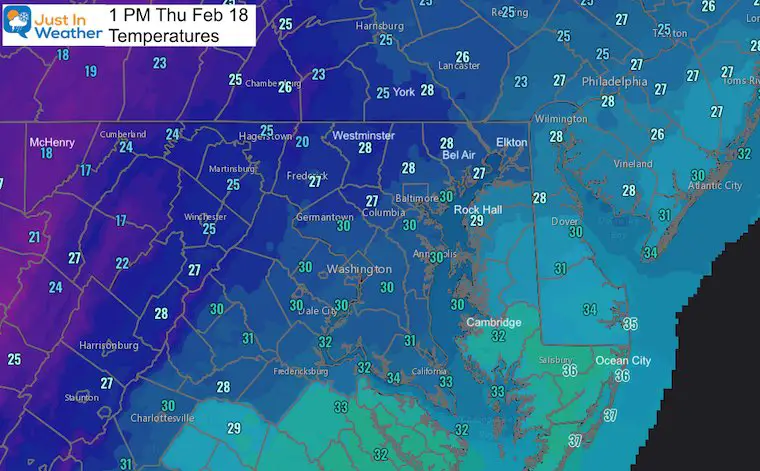
Tuesday February 18 Update at 1 PM
Do you want to explore that mess we had this morning? Would you prefer to hear about the new Winter Weather Advisory was just issued? We are not completely done yet, as more is on the way tonight. But I have to address what the heck just happened.
I consider anyone nailing this forecast in line with picking a perfect bracket in March Madness. Good luck with that!
I was wrong (as I wrote in my morning report), and yet kind of right. It was also pointed out to me that I was wrong about being wrong all at the same time. Sounds crazy, and my head is still spinning, but please let me explain.
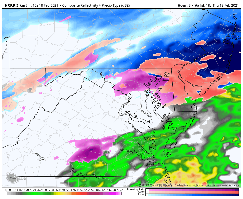
This split radar snapshot at 10:30 AM below helps tell the story of the morning weather. On the left is the raw radar showing intensity. On the right, winter precipitation mode. It is not perfect, but at that moment showed how wild the weather was this morning with pockets of heavy snow and sleet scattered around.
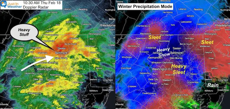
All of our region remains below freezing and The Winter Storm Warning is proving itself even if the snow didn’t pile as high as any of our maps showed you.
If at any point before this storm I gave this forecast, you would not buy it:
- Some areas will start with heavy snow and get 2” or more in the first hour, then turn to heavy sleet.
- Others places will start with heavy sleet, then switch to snow then freezing rain, then sleet and snow again.
- Others areas will get freezing rain, but switch to sleet, then heavy snow, then back to freezing rain.
- All this time, some areas will remain all snow and get over 6 inches.
That all happened in our areas, and it was sporadic! I can see the Memes already with maps of 1” to 20” of snow. Even putting every weather icon possible for the daily forecast. They both would actually fit.
Depending on where you are located, you may have seen more sleet today than ever before. That is not embellishing. I’ve been forecasting in this areas since I moved to Baltimore in 1997. I do this for a living and have not seen sleet like that over the last 23+ years. Meanwhile some remained with heavy snow, and others in the freezing rain.
More snow and ice are still on the way through tonight. See more below.
Snow Reports As of 11:38 AM
If this had remained all snow for just the first 3 hours, I am 100% convinced all snow forecasts would have verified. But the sleet monster took over!
Here are the preliminary map of spotter reports. I detail the BOG SPREAD across some counties below:
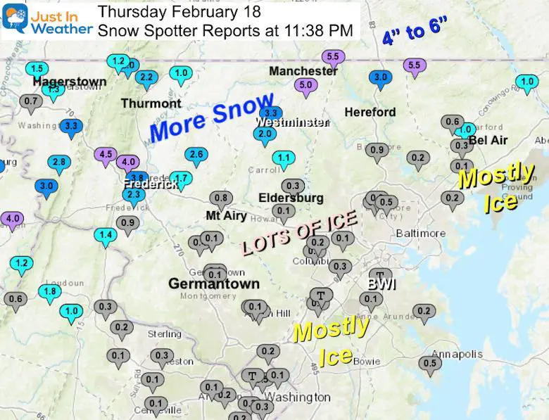
Biggest Spreads In Single Counties
…Baltimore County…
- Parkton 1 W 4.1 1050 AM 2/18 Trained Spotter
- Pimlico 1 NW 1.7 1030 AM 2/18 Trained Spotter
- Long Green 2 NW 1.0 1030 AM 2/18 Trained Spotter
- Cockeysville 2 WNW 0.9 914 AM 2/18 Broadcast Media
- Jacksonville 2 NE 0.8 855 AM 2/18 CoCoRaHS
- Towson 1 SW 0.3 900 AM 2/18 CoCoRaHS
- White Marsh 2 ESE 0.2 700 AM 2/18 CoCoRaHS
- Long Green 1 SW 0.2 700 AM 2/18 CoCoRaHS
- Glyndon 1 SW 0.1 928 AM 2/18 Trained Spotter
- Kingsville 1 E 0.1 700 AM 2/18 CoCoRaHS
…Carroll County…
- Manchester 1 SSW 6.5 1041 AM 2/18 Trained Spotter
- Millers 4 NE 5.5 812 AM 2/18 Co-Op Observer
- Westminster SE 3.3 745 AM 2/18 Trained Spotter
- Westminster 3 SSW 2.0 700 AM 2/18 CoCoRaHS
- Gamber 2 WNW 1.7 953 AM 2/18 Trained Spotter
- Mount Airy SE 0.8 745 AM 2/18 CoCoRaHS
- Eldersburg 1 SE 0.6 1000 AM 2/18 Trained Spotter
- Eldersburg 1 E 0.3 700 AM 2/18 CoCoRaHS
…Frederick County…
- Bloomfield 2 WSW 6.3 1100 AM 2/18 NWS Employee
- Myersville 2 ENE 6.0 1125 AM 2/18 Trained Spotter
- Myersville 2 SE 5.0 1100 AM 2/18 Trained Spotter
- Thurmont 1 SSE 4.5 1000 AM 2/18 CoCoRaHS
- Frederick 1 ENE 4.0 1025 AM 2/18 Trained Spotter
- Frederick 1 SW 3.8 800 AM 2/18 CoCoRaHS
- Sabillasville 2 SSE 3.0 900 AM 2/18 Trained Spotter
- Union Bridge 7 SSW 2.6 720 AM 2/18 CoCoRaHS
- Frederick 4 SSW 2.3 700 AM 2/18 CoCoRaHS
- Thurmont 3 N 2.2 700 AM 2/18 CoCoRaHS
- Sabillasville 2.0 730 AM 2/18 Trained Spotter
- Adamstown 1 ESE 1.8 1001 AM 2/18 NWS Employee
- Point of Rocks 1 NE 1.4 800 AM 2/18 Trained Spotter
- Emmitsburg 2 SE 1.0 640 AM 2/18 Co-Op Observer
When a Bust Is Not A Complete Bust
We have a winter storm and it is icy! All that have cancelled their travel plans were justified. You may very well measure less snow than my call, but we all remain below freezing. I consider a bust on a winter storm as it being wet or no storm at all. But I am a traditionalist. I am first to admit when my call is wrong as I did this morning.
I guess that debate will continue on social media.
My wife was prepared and content. That is a very important win.
My clients that plow snow were prepared for this. In fact, less snow and more ice actually means more work and money for them. So there is always some silver lining.
My clients that kept their schools virtual and closed buildings also made the correct call.
Weather Balloon Sounding
The National Weather service launches balloons twice a day across the country to gather weather data up through the atmosphere. That data is fed into computer models.
Here is the sounding from our regional location in Sterling, VA.
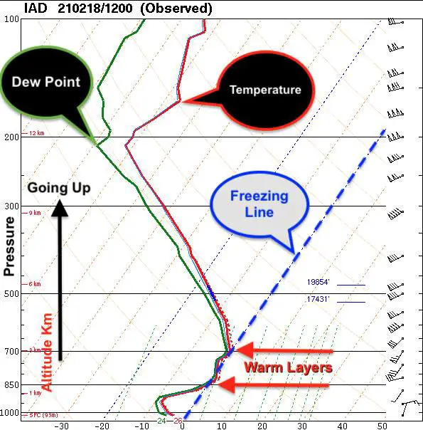
This Skew-T Diagram is something that gave me a lot of headaches learning during my second semester in my freshman year at Cornell. I wanted to simplify it.
The short story: Surface temps were in the 20s, but two layers aloft reached above freezing. We had cold air above and those fluffy flakes I mentioned last night. But when they fall into those warm layers, they melt, only to refreeze below.
Winter Precipitation
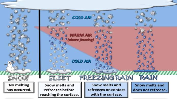
Depending on the temperatures of the new drops, and event the depth of cold air below determines is we get a refreeze back to sleet pellets, or staying rain freezes on contact (freezing rain).
When the heavier precipitation arrives like the 10:30 AM Radar above… That helps to drag down colder air and overtakes the warm layer… So bursts of heavy snow resulted even in Baltimore.
Here’s the kicker. Imagine all the different scenarios happening at the same time across the region, with very little indication to pin point… except the all snow zone.
Now we are all caught up to date, and I still have a headache. You too?
For The Record: It Is Still Below Freezing This Afternoon
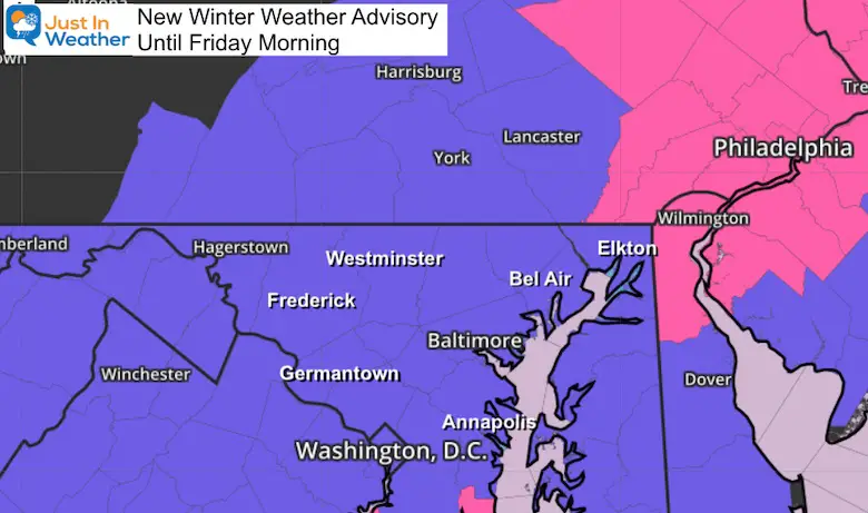
More On The Way?
Yes. This break in the activity was in my forecast and we will remain below freezing. Tonight is when we get a return for more freezing rain, sleet, and snow. Here is a quick animation through 4 AM (09Z) Friday.
I will do my best to fine tune this in my next report. Just plan on more ‘stuff’ to salt or push, and it will remain icy into Friday morning.
Winter Weather Advisory Until Friday Morning
Additional Snow and Sleet Up To 1 Inch
This includes Cecil County to Annapolis and Metro Washington, back into the mountains.
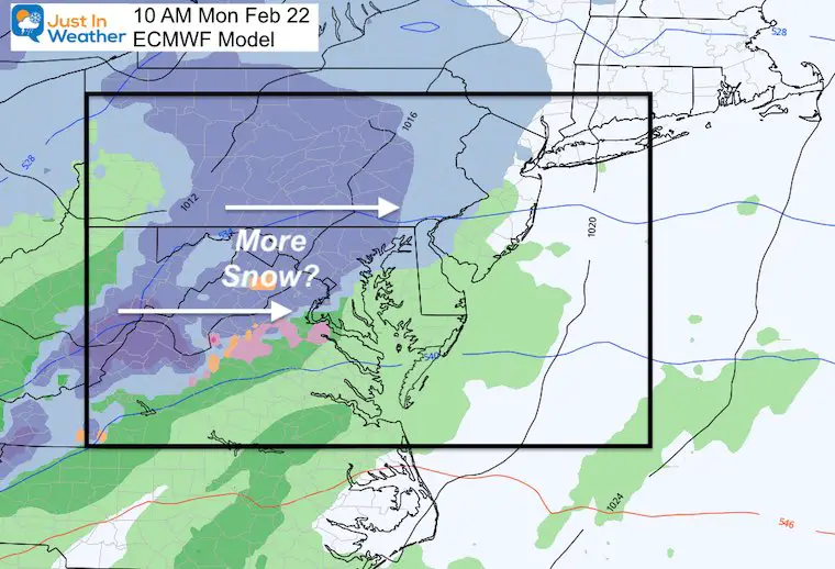
Even More On The Way Monday
I really don’t want to get ahead of my skis, but one more disturbance will arrive by Monday Morning. Hopefully this will be less complex.
Please share your thoughts, best weather pics/video, or just keep in touch via social media
Facebook: Justin Berk, Meteorologist
Twitter: @JustinWeather
Instagram: justinweather
14 Local Maryland Pages (and York PA)
We have made a page for Maryland Weather which gives you the current conditions for 14 present area locations.

Winter Outlook Series


FITF Shop Open
My ‘bonus’ daughter Jaiden and wife showing off our popular Maryland Hoodies. Unisex and women’s items all produced in Maryland.
Click here to see this and many other new items.

