February 17 2021 Evening Update
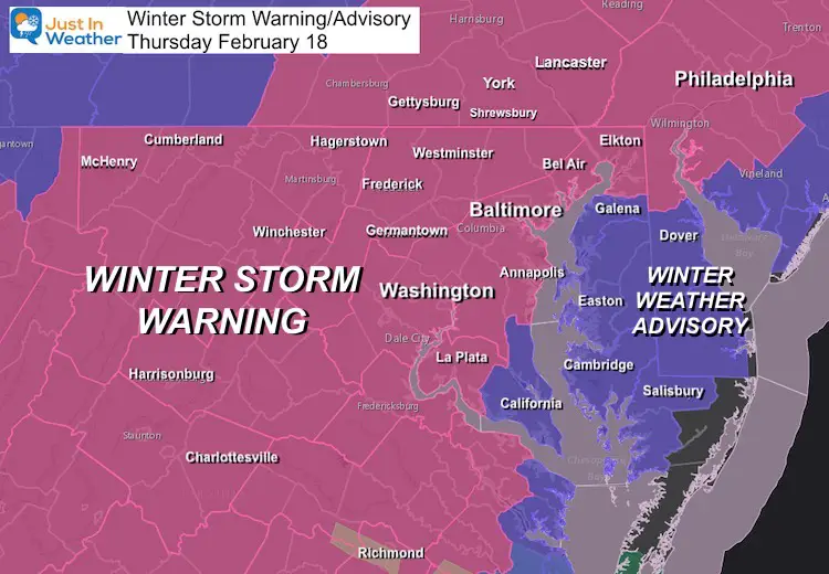
We now welcome Pennsylvania to the Winter Storm Warning and Delmarva to the Winter Weather Advisory map. Thursday February 18 will be our largest impact winter storm of the season. There will be plenty of snow and ice to go around if you have Faith in the Flakes. Temps will be cold enough for complete stickage.
I will do my best to explain my thinking for this event and my Final Call For Snowfall. Colder temps will fluff up the snow, leading to some overachieving. Ice in southern areas will be heavy and on top of fresh snow! This storm has already overachieved earlier today in Arkansas, Mississippi, and Tennessee. We must trust that it might be sending us a signal of what it is capable of.
I spent most of the afternoon working and fine tuning this as best I can. I hope it answers your question. Compare that to some model snow and ice maps below.
Winter Storm Warning and Winter Weather Advisory
- WARNING areas remain below freezing all day
- ADVISORY areas start with snow and ice, but should turn to rain.
Important Factors
- Starting: Before sunrise. The air is dry, so it may look like snow on radar for a few hours overnight before it reaches the ground (virga).
- The trend this winter has been for storms to arrive early, and maybe end early.
- Temperatures: Remain below freezing in most of our region all day Thursday! This mean maximum stickage!
- That is vital to decision making and road maintenance.
- Snow totals might be a game for us, and I expect overachieving in some areas.
- Ice from sleet and freezing rain will cut into some totals. This can turn extremely dangerous on top of new snow. I will spell that out below.
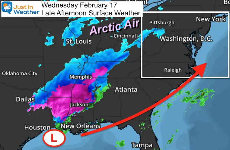
Late Afternoon Map
The Surface Low is located in the Gulf of Mexico south of Louisiana. What’s really crazy about this is that is a location where many hurricanes passed last summer. I wrote about this region feeding into our winter storm pattern in this winter outlook report.
It seems to be proving itself again. Now we have the edge of the arctic air moving in to help produce more snow when it arrives after midnight.
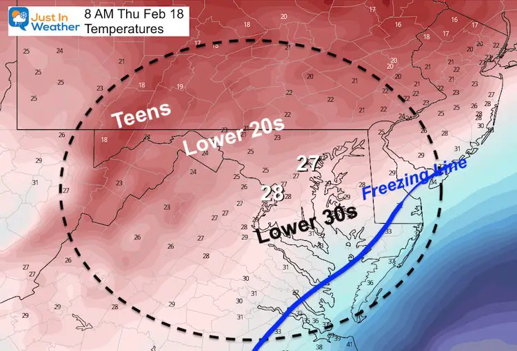
Morning Temperatures
This is vital to the forecast.
Morning
Stickage: The ground will be cold enough.
Fluffed Up Snow: When in the 20s, more snow is produced from the same amount of moisture
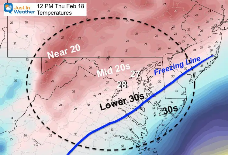
Noon
Numbers at the ground will not move much, but warmer air aloft will change some snow to ice from south to north.
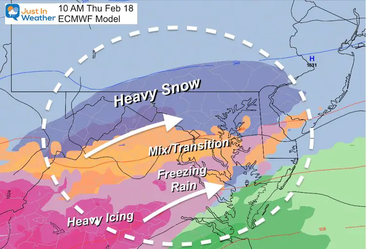
Mid Morning Snapshot
No Single Model will be perfect timing and locating the transition.
- Washington to Annapolis may mix with sleet any time between 9 AM and Noon.
- We will need to do a lot of nowcasting and crowdsourcing during the morning to track the change.
- Farther north, it will be later. Possibly remaining snow for the entire event in northern Maryland and southern PA. That would increase final snow.
Snow And Ice Forecasts
I want to show my map first, then look at the GFS and European Models to compare.
I wanted to explain why I went higher than they did.
My FINAL Call For Snowfall
Please see my notes below
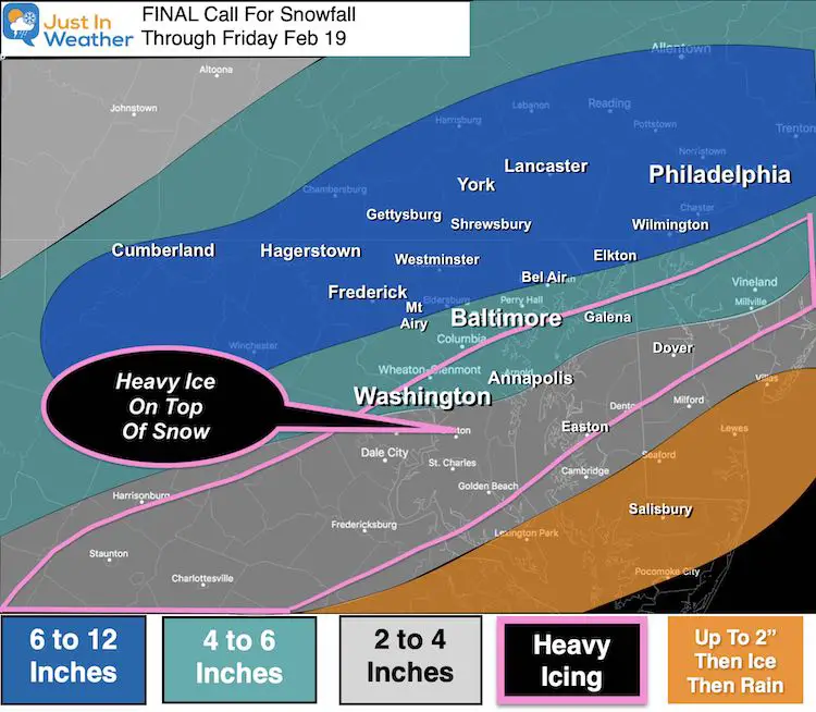
My Notes:
Temperatures: Starting the cold factor…
- Normally snow fall yields about 10 inches per 1 inch of liquid. That’s a 10:1 ratio.
- When temps are in the mid to lower 20s, that ratio can be 15:1 or higher.
- Also add in the energy to produce heavy snow for the first few hours… I had to bump to possibly be higher than models have suggested.
Heavy Icing:
- Sleet and Freezing Rain behave differently. Sleet bounces. Freezing rain feels like rain, but sticks and freezes on contact. Put with one on top of fresh snow and it all adds up to weigh a lot.
- Models below will show
- Sleet = 0.5” +
- Freezing Rain = 0.25” to 0.50”+
I highlighted where this will be on top of a few inches of snow. The combined results will take down trees and power lines. If you recall what happened in Virginia last weekend… That type of power outages will be more widespread and include more of metro DC and Maryland this time.
Computer Model Forecasts
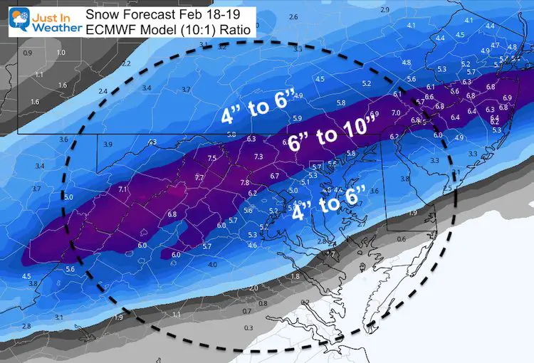
European Model
ICING: Sleet <—> Freezing Rain
Snowfall:
Note this is based on a 10:1 ratio. It does NOT factor in colder air fluffing up the flakes and results.
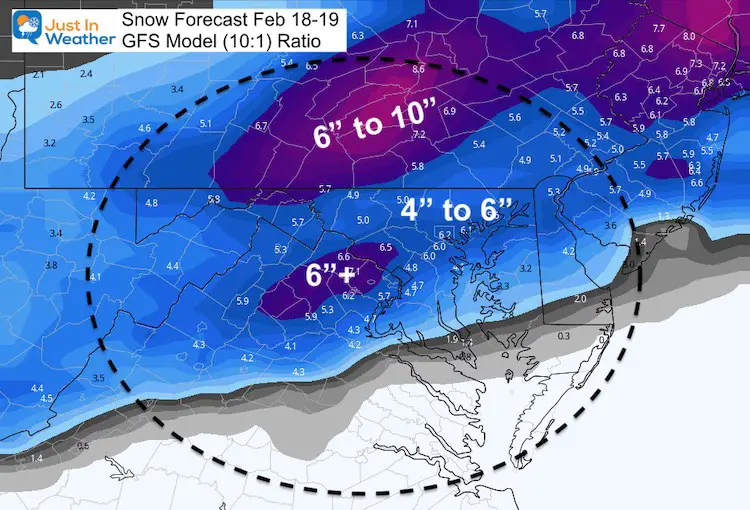
GFS Model
ICING: Sleet <—> Freezing Rain
Snowfall:
Note this is based on a 10:1 ratio. It does NOT factor in colder air fluffing up the flakes and results.
My Next Update:
This evening I will post the timelines I think may do the best job with the snow arrival and timing the change to ice.
Please share your thoughts, best weather pics/video, or just keep in touch via social media
Facebook: Justin Berk, Meteorologist
Twitter: @JustinWeather
Instagram: justinweather
14 Local Maryland Pages (and York PA)
We have made a page for Maryland Weather which gives you the current conditions for 14 present area locations.
Winter Outlook Series
FITF Shop Open
My ‘bonus’ daughter Jaiden and wife showing off our popular Maryland Hoodies. Unisex and women’s items all produced in Maryland.
Click here to see this and many other new items.


