Thursday February 11 2021
I am so happy to report that this storm ending this morning produced snow for many areas that have missed out on recent events. I am also happy since it worked out for about 90% of my call. It was even sweeter paying close attention to the north Bay coastal area and they hit their target. No BUST there!
The “GRADE MY FORECAST ” poll is below.
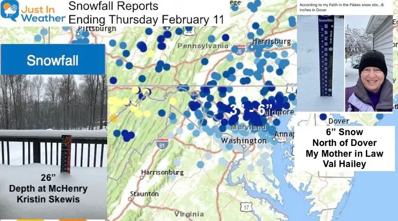
I have many local snow maps and spotter lists to show you. Snow covers most of our region, and I wanted to start with this one map (but it might be hard to see).
McHenry in western Maryland has 26” of snow on the ground, according to Kristin Skewis.
In Dover, DE my mother in-law measured 6” of new snow today as one of the top spots.
Annapolis
The state capital received just under 2 inches, but it was enough to change the landscape and break the snow drought bubble
Even just an inch or so of snow is enough to make Annapolis look spectacular! #FITF ❄️ ❤️ https://t.co/bXp4zc4AhM
— Justin Berk (@JustinWeather) February 11, 2021
This was originally expected to be a two part event, but this first part verified my original call and the follow up maps. I will show all below.
The second part is passing through southern Delmarva tonight, so I will update that region when it is complete. We have a busy pattern ahead, so I wanted to post this report so we can get focused on the ice storm on the way.
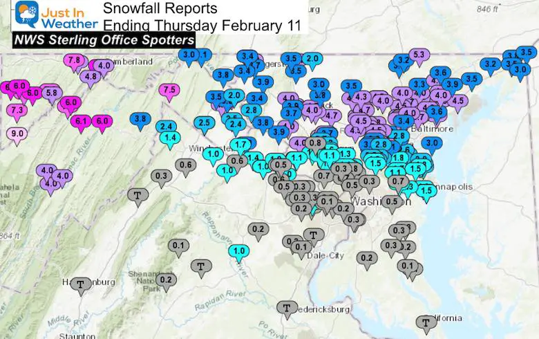
Snow Spotter Map (NWS Sterling Office)
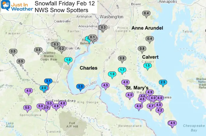
ADDED PART 2 Additional Snow Friday Morning
St. Mary’s Co got over 4 inches of snow
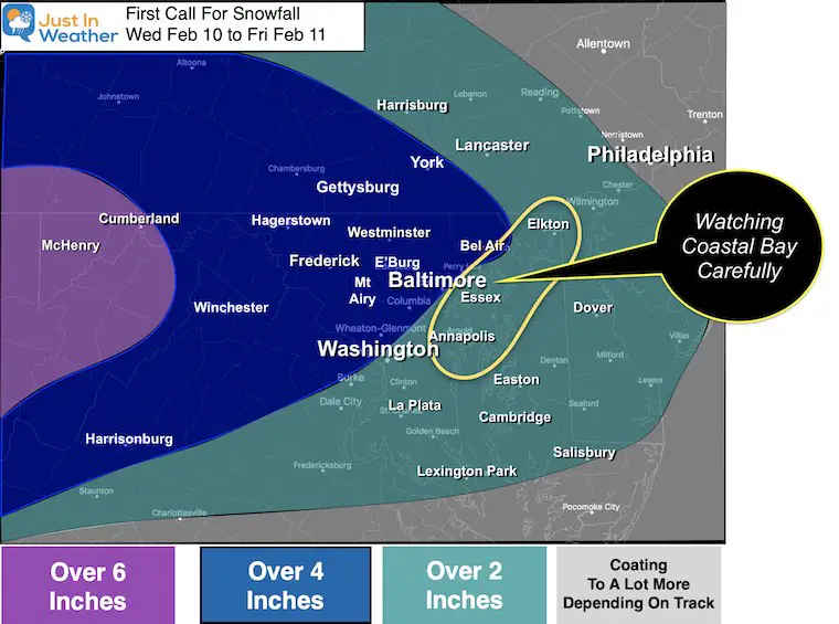
My Original Forecast
Wed through Friday (The date in the title should be Feb 10 to Feb 12)
Winter Storm Warnings and Winter Weather Advisories
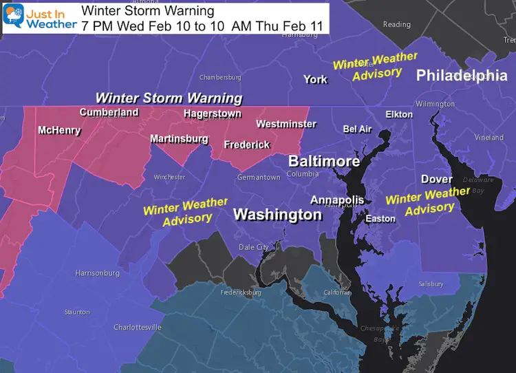
My Snow Forecast(s)
I made a few adjustments as new info showed some intensification.
Slider showing all off my maps
Final Call —-> prior calls
Official Reporting Stations
BWI: 2.6 inches
- (My forecast was 2 to 4)
Washington National: 0.8”
- (My forecast was Coating to 2”)
Dulles: 0.5”
- (My forecast was 2 to 4)
Morning Results
What went right:
- Timing, stickage, and most accumulations
- Southern Maryland : Starting and ending with snow, but rain in between.
What went wrong:
- I went too high with snow in PA.
- A little more snow verified in parts of northern Delmarva
- Right along the line in Washington was wet in the morning
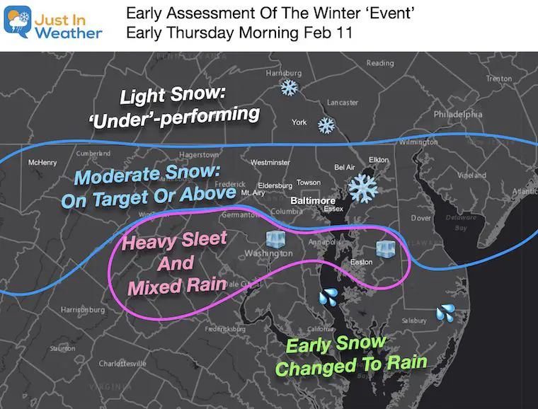
Please Grade My Forecast
Open Until 8 Pm Friday
Consider the information I shared as well as the final result.
See the county snow maps and spotter lists below for reference
Snow Reports
I included my forecast for each region to compare.
Northeast Maryland
Harford and Cecil Counties
My Forecast: 2 to 4 inches; up to 6″ north
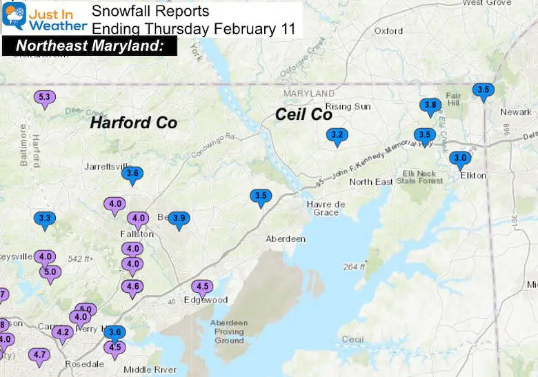
…Harford County…
Norrisville 1 WSW 5.3 625 AM 2/11 CoCoRaHS
Abingdon 1 SE 4.5 624 AM 2/11 Trained Spotter
Bel Air 2 W 4.0 700 AM 2/11 CoCoRaHS
Forest Hill 3 SW 4.0 700 AM 2/11 Trained Spotter
Fallston 2 ESE 4.0 800 AM 2/11 CoCoRaHS
Kingsville 3 NNE 4.0 700 AM 2/11 CoCoRaHS
Bel Air 2 E 3.9 1100 AM 2/11 Trained Spotter
Forest Hill 1 NNW 3.6 645 AM 2/11 Trained Spotter
Havre De Grace 4 WNW 3.5 1000 AM 2/11 CoCoRaHS
…Cecil County…
Fair Hill 1 SW 3.8 1040 AM 2/11 Trained Spotter
Glen Westover 3.5 713 AM 2/11 Trained Spotter
Elkton 5 NW 3.5 700 AM 2/11 CoCoRaHS
Woodlawn 2 ENE 3.2 1028 AM 2/11 Trained Spotter
Elkton 1 NNW 3.0 800 AM 2/11 CoCoRaHS
Baltimore County and City
My Forecast: 2 to 4 inches; up to 6″ north
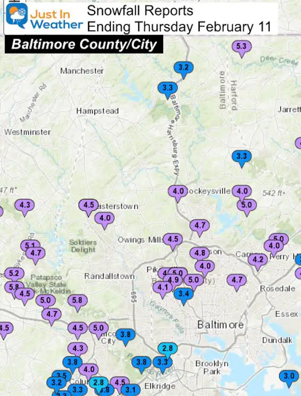
…Baltimore County…
Glyndon 1 WSW 5.0 1153 AM 2/11 Trained Spotter
Perry Hall 1 NNE 5.0 825 AM 2/11 Trained Spotter
Long Green 1 SW 5.0 700 AM 2/11 CoCoRaHS
Towson 1 SW 4.8 830 AM 2/11 CoCoRaHS
Upper Falls 1 NNE 4.7 1145 AM 2/11 Trained Spotter
Timonium NE 4.7 700 AM 2/11 CoCoRaHS
Kingsville 1 E 4.6 700 AM 2/11 CoCoRaHS
White Marsh 2 ESE 4.5 700 AM 2/11 CoCoRaHS
Brooklandville 4.5 847 AM 2/11 Broadcast Media
Glyndon 1 SW 4.5 807 AM 2/11 Trained Spotter
Fullerton 1 N 4.2 807 AM 2/11 Trained Spotter
Pimlico 1 NW 4.1 925 AM 2/11 Trained Spotter
Reisterstown 1 ESE 4.0 630 AM 2/11 Trained Spotter
Long Green 2 NW 4.0 550 AM 2/11 Trained Spotter
Perry Hall 4.0 816 AM 2/11 Broadcast Media
Cockeysville 2 WNW 4.0 634 AM 2/11 Broadcast Media
Catonsville 1 NW 3.8 800 AM 2/11 CoCoRaHS
Catonsville 1 SSE 3.8 800 AM 2/11 Trained Spotter
White Marsh 2 E 3.6 700 AM 2/11 Trained Spotter
Parkton 1 W 3.3 1030 AM 2/11 Trained Spotter
Halethorpe SW 3.3 815 AM 2/11 CoCoRaHS
Jacksonville 2 NE 3.3 858 AM 2/11 CoCoRaHS
Bentley Springs 1 E 3.2 600 AM 2/11 Trained Spotter
Edgemere ESE 3.0 656 AM 2/11 Trained Spotter
..Baltimore City…
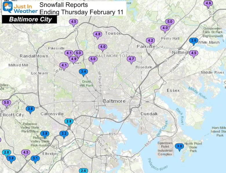
Pikesville 2 SE 5.1 1030 AM 2/11 CoCoRaHS
Mount Washington 1 N 5.0 800 AM 2/11 CoCoRaHS
Park Heights 2 NNW 5.0 800 AM 2/11 Trained Spotter
Pimlico SE 4.9 620 AM 2/11 Trained Spotter
Hamilton NE 4.7 600 AM 2/11 CoCoRaHS
Arlington 1 NNW 4.1 806 AM 2/11 Trained Spotter
Towson 1 SSE 4.0 715 AM 2/11 Trained Spotter
Arlington 2 ESE 3.4 525 AM 2/11 Broadcast Media
Morrell Park 1 W 2.8 835 AM 2/11 Trained Spotter
Frederick and Carroll Counties
My Forecast: 2 to 4 inches; up to 6″ north
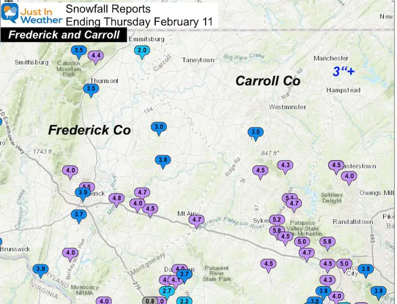
…Frederick County…
Frederick 5.5 833 AM 2/11 Broadcast Media
Mount Pleasant 3 SSW 4.8 613 AM 2/11 Public
New Market 3 NNW 4.7 700 AM 2/11 CoCoRaHS
New Market N 4.5 705 AM 2/11 Trained Spotter
Thurmont 3 N 4.4 700 AM 2/11 CoCoRaHS
Adamstown 1 ESE 4.0 1000 AM 2/11 NWS Employee
Bloomfield 2 WSW 4.0 945 AM 2/11 NWS Employee
New Market 2 NW 4.0 830 AM 2/11 CoCoRaHS
Frederick 1 SW 3.9 730 AM 2/11 CoCoRaHS
Point of Rocks 1 NE 3.9 800 AM 2/11 Trained Spotter
Union Bridge 7 SSW 3.8 700 AM 2/11 CoCoRaHS
Rosemont 1 WSW 3.8 1020 AM 2/11 Trained Spotter
Frederick 4 SSW 3.7 700 AM 2/11 CoCoRaHS
Thurmont 1 SSE 3.5 700 AM 2/11 CoCoRaHS
Sabillasville 2 SSE 3.5 1000 AM 2/11 Trained Spotter
Woodsboro 3 E 3.0 828 AM 2/11 Trained Spotter
Emmitsburg 2 SE 2.0 625 AM 2/11 Co-Op Observer
…Carroll County…
Sykesville 5.2 758 AM 2/11 Trained Spotter
Eldersburg 5.1 728 AM 2/11 Broadcast Media
Eldersburg 1 E 4.7 700 AM 2/11 CoCoRaHS
Mount Airy SE 4.7 730 AM 2/11 CoCoRaHS
Sykesville 6 NNW 4.5 800 AM 2/11 CoCoRaHS
Gamber 1 W 4.3 700 AM 2/11 CoCoRaHS
Westminster 3 SSW 3.5 700 AM 2/11 CoCoRaHS
Western Maryland:
My Forecast: Mostly 4 to 6”+
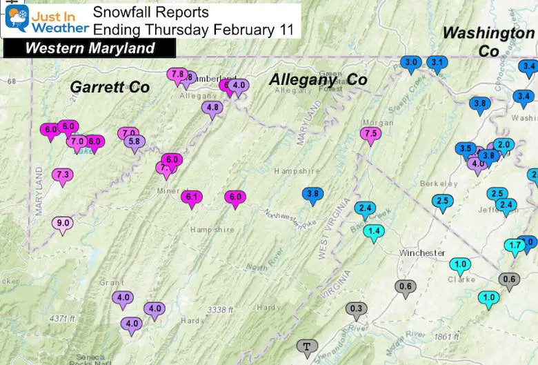
…Garrett County…
Frostburg 3 WNW 7.8 810 AM 2/11 Trained Spotter
Mountain Lake Park 7.3 600 AM 2/11 CoCoRaHS
Warnocks 4 NW 7.0 700 AM 2/11 HADS
McHenry 5 SSE 7.0 800 AM 2/11 CoCoRaHS
Mc Henry 4 SW 6.0 700 AM 2/11 Co-Op Observer
Deer Park 6 NE 6.0 700 AM 2/11 Trained Spotter
McHenry 1 S 6.0 645 AM 2/11 Trained Spotter
Bloomington 3 WNW 5.8 900 AM 2/11 Trained Spotter
..Allegany County…
Ridgeley 1 W 6.5 900 AM 2/11 Trained Spotter
Cresaptown-Bel Air 1 4.8 700 AM 2/11 CoCoRaHS
Frostburg 4.8 700 AM 2/11 Co-Op Observer
Cumberland 4.0 700 AM 2/11 Co-Op Observer
…Washington County…
Long Meadow 1 SSE 4.0 900 AM 2/11 Trained Spotter
Boonsboro 3 NNE 3.9 900 AM 2/11 Trained Spotter
Hagerstown 1 ENE 3.7 700 AM 2/11 CoCoRaHS
Long Meadow 2 W 3.4 700 AM 2/11 Trained Spotter
Keedysville 2 SSE 3.4 700 AM 2/11 CoCoRaHS
Williamsport 3 ENE 3.4 600 AM 2/11 CoCoRaHS
Hagerstown 4 NNW 3.4 700 AM 2/11 CoCoRaHS
Pecktonville 3 NNW 3.1 711 AM 2/11 NWS Employee
Hancock 1 ESE 3.0 700 AM 2/11 CoCoRaHS
Sharpsburg 5 S 2.8 700 AM 2/11 Co-Op Observer
Capital Area: Montgomery, Howard, and DC
My Forecast: 2 to 4 inches
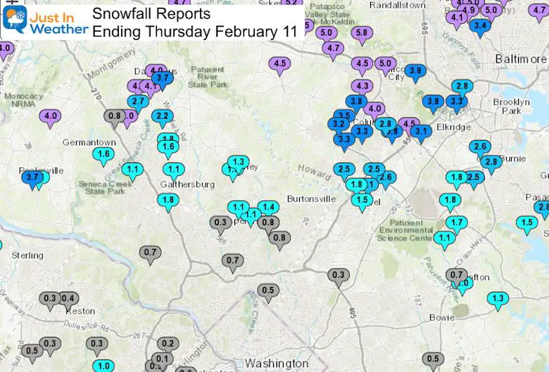
…Montgomery County…
Damascus 3 SSW 4.3 900 AM 2/11 Co-Op Observer
Damascus 1 S 4.1 658 AM 2/11 Trained Spotter
Barnesville 4.0 630 AM 2/11 County Emrg Mgmt
Clarksburg 2 SE 4.0 700 AM 2/11 Trained Spotter
Damascus 4.0 630 AM 2/11 County Emrg Mgmt
Poolesville 3.7 600 AM 2/11 County Emrg Mgmt
Damascus 1 SE 3.7 700 AM 2/11 Trained Spotter
Laytonsville 5 NNW 3.7 700 AM 2/11 CoCoRaHS
Germantown 5 NNE 2.7 600 AM 2/11 CoCoRaHS
Laytonsville 2 WNW 2.2 742 AM 2/11 Trained Spotter
Montgomery Village 1 1.8 630 AM 2/11 CoCoRaHS
Rockville 3 NNW 1.8 806 AM 2/11 NWS Employee
Gaithersburg 3 NE 1.6 700 AM 2/11 CoCoRaHS
Germantown 2 WSW 1.6 1030 AM 2/11 Trained Spotter
Colesville 1 NNW 1.4 700 AM 2/11 CoCoRaHS
Olney 1 E 1.3 630 AM 2/11 Trained Spotter
Colesville 1.3 800 AM 2/11 Trained Spotter
Olney 1 ENE 1.3 630 AM 2/11 CoCoRaHS
Poolesville SE 1.1 800 AM 2/11 CoCoRaHS
North Potomac 4 N 1.1 700 AM 2/11 CoCoRaHS
Colesville 2 W 1.1 700 AM 2/11 CoCoRaHS
Norbeck 1 ESE 1.1 700 AM 2/11 CoCoRaHS
Washington Grove 1 N 1.1 853 AM 2/11 Trained Spotter
Clarksburg 1 SSE 0.8 1200 AM 2/11 CoCoRaHS
White Oak 1 N 0.8 700 AM 2/11 CoCoRaHS
Silver Spring 6 NNE 0.8 430 AM 2/11 CoCoRaHS
Potomac 1 NNW 0.7 700 AM 2/11 CoCoRaHS
Kensington W 0.7 900 AM 2/11 CoCoRaHS
Takoma Park 1 NNW 0.5 700 AM 2/11 CoCoRaHS
Aspen Hill 1 SW 0.3 715 AM 2/11 Trained Spotter
…Howard County…
Sykesville 2 SSE 5.8 700 AM 2/11 CoCoRaHS
Granite 1 SSE 5.8 605 AM 2/11 Trained Spotter
Oella 1 NW 5.0 945 AM 2/11 Trained Spotter
Marriottsville 2 SSW 5.0 600 AM 2/11 NWS Employee
Marriottsville 3 S 4.7 700 AM 2/11 CoCoRaHS
Historic Ellicott Ci 4.5 907 AM 2/11 Trained Spotter
Glenelg 2 N 4.5 800 AM 2/11 Trained Spotter
Elkridge 1 WNW 4.5 1000 AM 2/11 Trained Spotter
Sykesville 3 SE 4.5 700 AM 2/11 CoCoRaHS
Ellicott City 1 SW 4.3 810 AM 2/11 Trained Spotter
Columbia 2 NE 4.0 900 AM 2/11 Trained Spotter
Columbia 2 N 3.8 1000 AM 2/11 Trained Spotter
Elkridge 2 W 3.8 1000 AM 2/11 Trained Spotter
Columbia 2 NW 3.5 610 AM 2/11 Trained Spotter
Columbia 3.3 758 AM 2/11 NWS Employee
Simpsonville E 3.3 900 AM 2/11 Trained Spotter
Simpsonville 2 NNW 3.2 1034 AM 2/11 Trained Spotter
Elkridge 3.1 800 AM 2/11 NWS Employee
Columbia 3 ENE 2.8 1115 AM 2/11 Trained Spotter
Savage 1 ESE 2.6 800 AM 2/11 Trained Spotter
Savage 1 N 2.5 1000 AM 2/11 Trained Spotter
Scaggsville 1 ENE 2.5 800 AM 2/11 NWS Employee
North Laurel 2 ESE 2.1 700 AM 2/11 CoCoRaHS
Laurel 2 N 1.8 900 AM 2/11 Trained Spotter
Laurel 1 NNE 1.5 600 AM 2/11 CoCoRaHS
Anne Arundel
My Forecast: 2” to 4”
Annapolis and south: Coating to 2 inches
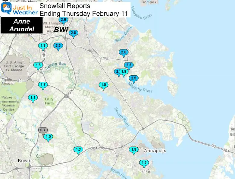
Pasadena 1 SE 2.8 700 AM 2/11 CoCoRaHS
Glen Burnie 1 WSW 2.8 830 AM 2/11 Trained Spotter
Bwi Airport 2.6 700 AM 2/11 Airport
Pasadena 3 ESE 2.5 800 AM 2/11 CoCoRaHS
Severn 2 E 2.5 730 AM 2/11 CoCoRaHS
Chelsea Beach NNE 2.3 730 AM 2/11 Trained Spotter
Green Haven 1 ESE 2.0 615 AM 2/11 Trained Spotter
Severn 2 SSW 1.8 911 AM 2/11 CoCoRaHS
Annapolis 1 NNW 1.8 1150 AM 2/11 Trained Spotter
Chelsea Beach 1.8 715 AM 2/11 Trained Spotter
Severn NE 1.8 900 AM 2/11 Trained Spotter
Odenton 1 N 1.7 730 AM 2/11 CoCoRaHS
Severna Park 1.5 1000 AM 2/11 Trained Spotter
Annapolis 1 SE 1.5 720 AM 2/11 CoCoRaHS
Eastport 1 SSW 1.5 723 AM 2/11 Trained Spotter
Crownsville 3 SSW 1.3 1015 AM 2/11 Trained Spotter
Odenton 1 WNW 1.1 653 AM 2/11 Trained Spotter
Crofton 1 SSE 1.0 815 AM 2/11 NWS Employee
Crofton 2 NNE 0.7 818 AM 2/11 NWS Employee
Southern Maryland
My Forecast: Coating to 2 Inches
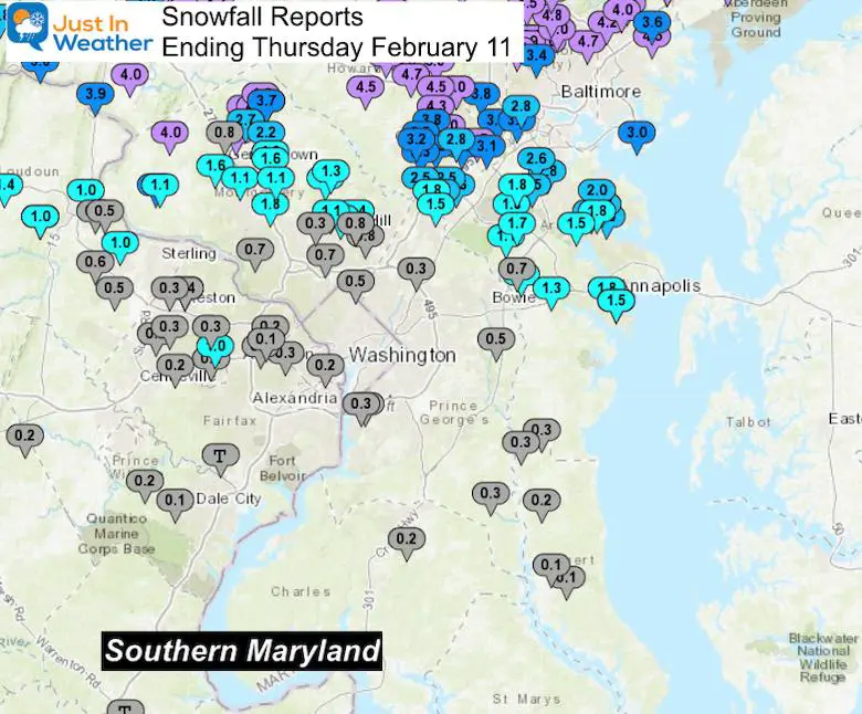
ADDED PART 2 Additional Snow Friday Morning
St. Mary’s Co got over 4 inches of snow

Southern Pennsylvania
My Forecast: 3” to 6” +
I overshot it for some as the heavier snow stayed south this time.
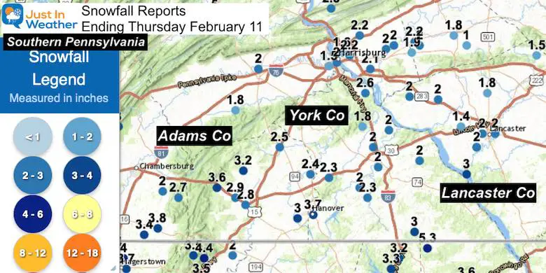
…Adams County…
1 W Cashtown 3.6 in 0845 AM 02/11 CO-OP Observer
Biglerville 3.2 in 0800 AM 02/11 COOP
Hanover 3.5 WSW 3.0 in 0700 AM 02/11 COCORAHS
Gettysburg 2.5 WNW 2.9 in 0700 AM 02/11 COCORAHS
Gettysburg 0.3 W 2.8 in 0700 AM 02/11 COCORAHS
York Springs 0.7 SE 2.5 in 0700 AM 02/11 COCORAHS
Abbottstown 2.4 N 2.4 in 0700 AM 02/11 COCORAHS
…York County…
Stewartstown 0.5 S 3.0 in 0700 AM 02/11 COCORAHS
Seven Valleys 2.3 in 0830 AM 02/11 Public
1 S York 2.0 in 0900 AM 02/11 Trained Spotter
Yorkana 1.4 SE 2.0 in 0800 AM 02/11 COCORAHS
1 S New Salem 2.0 in 0800 AM 02/11 Trained Spotter
Mount Wolf 1.0 SE 2.0 in 0700 AM 02/11 COCORAHS
York 2.5 NNW 2.0 in 0700 AM 02/11 COCORAHS
Manchester 3.6 W 1.8 in 0700 AM 02/11 COCORAHS
…Lancaster County…
Safe Harbor 3.0 in 0800 AM 02/11 COOP
Elizabethtown 2.0 in 0900 AM 02/11 Public
2 NNE Mount Joy 2.0 in 0821 AM 02/11
1 E Lancaster 2.0 in 0800 AM 02/11
2 W Lancaster 2.0 in 0715 AM 02/11 Public
Millersville 1 S 2.0 in 0700 AM 02/11 COOP
Lititz 0.3 WNW 1.8 in 0800 AM 02/11 COCORAHS
Adamstown 2.5 SSE 1.7 in 0700 AM 02/11 COCORAHS
3 NNE Denver 1.5 in 0715 AM 02/11 Public
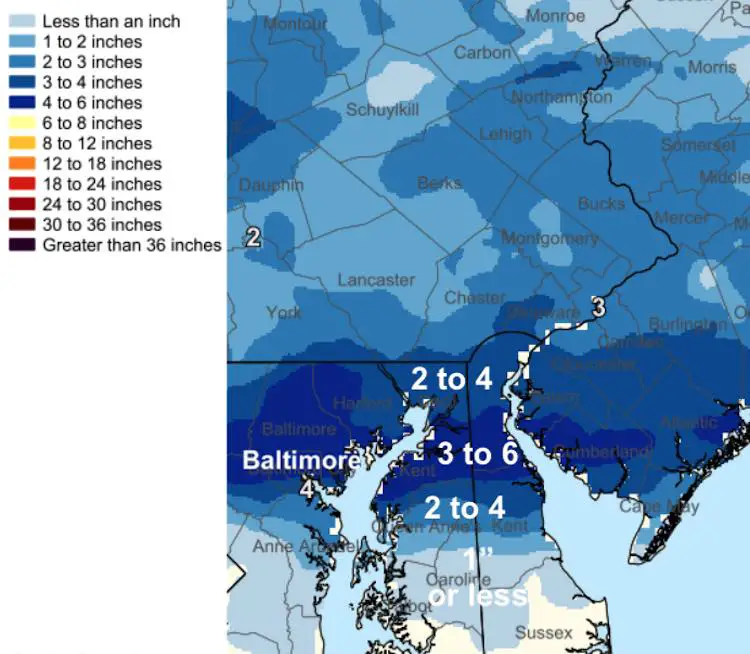
Eastern Shore and Delaware
NWS in Mount Holly did not provide a list of spotters, but generated this map.
I did receive many reports online ranging from 2 to 6 inches.
My Mother In Law (seen at the top) was in Dover and I will NOT argue with her accurate report.
Please share your thoughts, best weather pics/video, or just keep in touch via social media
Facebook: Justin Berk, Meteorologist
Twitter: @JustinWeather
Instagram: justinweather
14 Local Maryland Pages (and York PA)
We have made a page for Maryland Weather which gives you the current conditions for 14 present area locations.
FITF Shop Open
My ‘bonus’ daughter Jaiden and wife showing off our popular Maryland Hoodies. Unisex and women’s items all produced in Maryland.
Click here to see this and many other new items.


