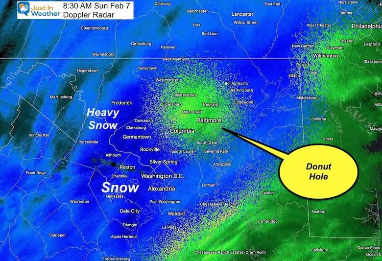
The Radar That Represents This Storm
Before we get to the snow reports to compare my forecast and grade, I have a question for you. How could anyone nail this? This radar image at 8:30 AM shows snow almost everywhere, except that donut (or no-nut) over Baltimore.
It was actually snowing in much of Baltimore at that time, but not everywhere as the winter mode tried to let us know. There were up to 5 inches of snow in spots west, north, southern Maryland, and on Delmarva. Meanwhile some are Baltimore barely got a coating.
Baltimore Notes
Snow falling but melting was the main problem around the airport, city, and by the Bay.
BWI was 41ºF when rain began at 4 AM. Then light snow mixed in at 5:23 AM. The lowest temperature was 33ºF at 9 AM
Total moisture for the event was 0.47”. If all of that was snow that stuck, it could have easily added up to about 5 inches.
I had accounted for some melting with my low end of my range at 3” there, but that wasn’t low enough.
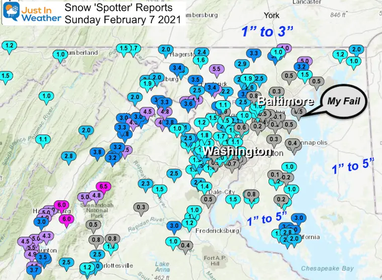
Official Snow Totals:
- BWI = 0.1”
- Washington National = 0.3”
- Dulles = 1.8”
Click here for the Seasonal Totals
Other areas:
Inland, Southern Maryland, AND Delmarva = All had reports of 1” to 5”
I was surprised when I tweeted my snow photo, this report of 5 inches of snow in Hollywood, MD. That is in St. Mary’s County!
Hollywood, Md- SOMD! pic.twitter.com/OLggfW9NRF
— Robbie Boothe (@RobbieBoothe) February 7, 2021
Wide Map
I know I subject myself to a lot of criticism as a meteorologist holding myself accountable for a winter forecast. Even when I (or we) do a good job, some will find fault. This time there is a small part of our region with a big reason to complain. So, I have a feeling how this is going to go:
If you live in central Maryland within 10 miles of the water, you got little to no snow sticking and will likely say this was a BUST and I deserve an F.
If you are inland, or in southern Maryland, or on Delmarva then you got the snow burst and accumulation near or in my forecast range. Even southern PA hit my final call lowered snow range. There I will likely get a B or even an A.
I guess I failed for 10% of our region. But if you are in that 10%, that is all that matters.
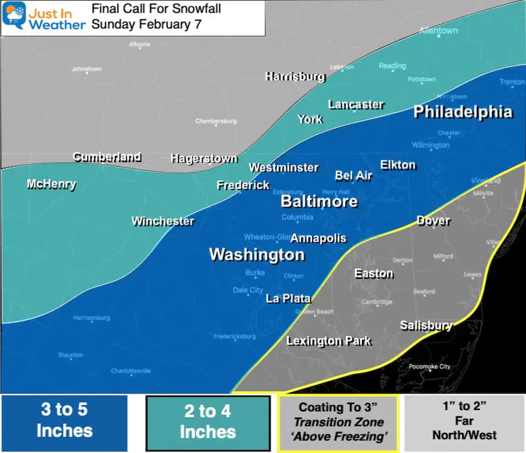
My Final Call For Snowfall
I lowered the top snow to 5″ and shaved back the north and south edges.
What Happened?
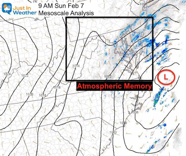
I should have seen this: Low Pressure tracked closer to the coast. That kept the air just a tad warmer. The reason is something I mentioned in my forecast posts… The Low tracked close to where our last storm was located (Atmospheric Memory)
What Else Went Wrong
- The change over to snow near I-95 was at or after sunrise, instead of before. That limited the chance for snow to overtake the warmer ground.
- Just enough warmth from the Bay influenced areas within about 10 miles from the water. The result was snow not sticking or more rain.
What Went Right
- Precipitation began before sunrise with rain in metro areas.
- Snow took over for many before sunrise.
- Snow was sticking inland even with temperatures above freezing.
- Burst of heavy snow did accumulate southern Maryland and Delmarva
- Bursts of heavy snow did fall at the rate of 1 to 2 inches per hour at times. *The flakes were big!
My Slow Mo Snow Video
Below is the break down of snow reports by region. Please review and compare to my forecast maps at the bottom of this post.
GRADE MY FORECAST
You decide if you want to grade my on your location, the entire region, or all of the informative updates. Be honest, I can take it.
Averaging the BUST and The Success, I am torn:
I would give a hard C+, but petition for a B-. But I am going to simplify with whole grades here.
What do you think?
Poll is open until 8 PM Tue Feb 9
Grade My Forecast: Feb 7 2021
- A (36%, 1,365 Votes)
- B (27%, 1,006 Votes)
- C (16%, 585 Votes)
- D (11%, 429 Votes)
- F (10%, 384 Votes)
Total Voters: 3,769
Regional Snow Maps
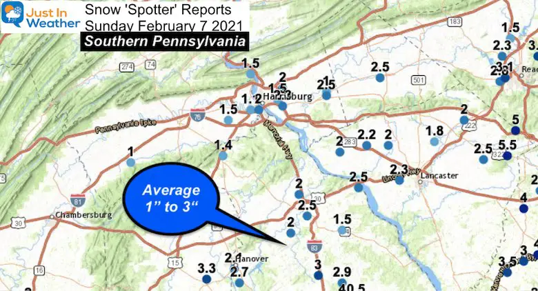
Southern Pennsylvania
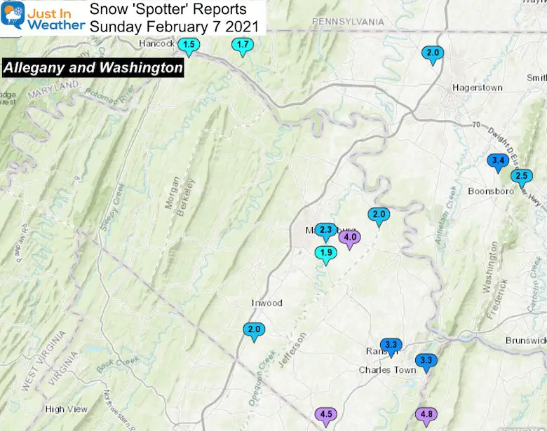
Maryland (Western) and Northern VA/WV
…Washington County…
- Boonsboro 3 NNE 3.4 1200 PM 2/07 Trained Spotter
- Long Meadow 2 W 2.0 108 PM 2/07 Trained Spotter
- Pecktonville 3 NNW 1.7 1059 AM 2/07 Co-Op Observer
- Hancock 1 ESE 1.5 1000 AM 2/07 Trained Spotter
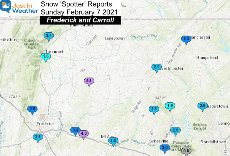
Frederick and Carroll Counties
…Frederick County…
- Woodsboro 3 E 5.5 1042 AM 2/07 Trained Spotter
- Point of Rocks 2 N 4.5 100 PM 2/07 Trained Spotter
- Adamstown 1 ESE 4.1 1100 AM 2/07 NWS Employee
- New Market N 4.0 100 PM 2/07 Trained Spotter
- Point of Rocks 1 NE 3.6 1200 PM 2/07 Trained Spotter
- Bloomfield 2 WSW 3.5 1030 AM 2/07 NWS Employee
- New Market 2 NW 3.4 830 AM 2/07 CoCoRaHS
- Pleasant Walk 1 SW 2.5 1200 PM 2/07 Trained Spotter
- Frederick 4 SSW 2.5 750 AM 2/07 CoCoRaHS
- Thurmont 3 N 2.4 1200 PM 2/07 NWS Employee
- Thurmont 1 SSE 1.6 1000 AM 2/07 CoCoRaHS
…Carroll County…
- Manchester 1 SW 5.7 045 PM
- Manchester 3.3 1033 AM 2/07 County Emrg Mgmt
- Westminster SE 2.9 1140 AM 2/07 Trained Spotter
- Eldersburg 1 SE 2.6 1225 PM 2/07 Trained Spotter
- Sykesville 6 NNW 2.5 800 AM 2/07 CoCoRaHS
- Mount Airy SE 2.2 830 AM 2/07 CoCoRaHS
- Gamber 1 WNW 1.9 1043 AM 2/07 CoCoRaHS
- Gamber 1 W 1.9 1030 AM 2/07 CoCoRaHS
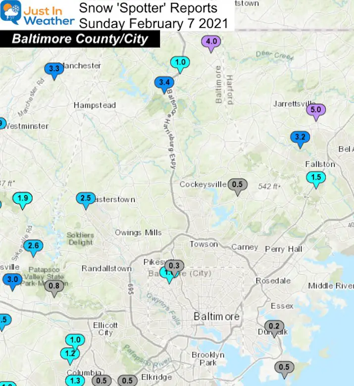
Baltimore County and City
…Baltimore County…
- Norrisville 3 W 4.0 100 PM 2/07 Trained Spotter
- Parkton 1 W 3.4 1010 AM 2/07 Trained Spotter
- Glyndon 1 SW 2.5 1035 AM 2/07 Trained Spotter
- Bentley Springs 1 E 1.0 945 AM 2/07 Trained Spotter
- Long Green 2 NW 0.5 945 AM 2/07 Trained Spotter
- Edgemere ESE 0.5 1148 AM 2/07 Trained Spotter
- Back River 2 WNW 0.2 853 AM 2/07 Trained Spotter
…Baltimore City…
- Pimlico SE 1.0 1035 AM 2/07 Trained Spotter
- Mount Washington 1 N 0.3 900 AM 2/07 CoCoRaHS
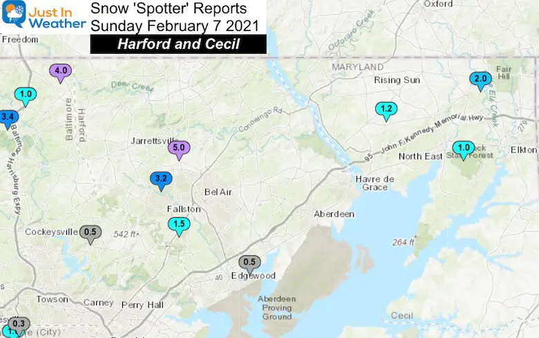
Harford and Cecil
…Harford County...
- Forest Hill 1 NNW 5.0 1240 PM 2/07 Trained Spotter
- Forest Hill 3 SW 3.2 1200 PM 2/07 Trained Spotter
- Fallston 2 ESE 1.5 900 AM 2/07 CoCoRaHS
- Abingdon 1 SE 0.5 107 PM 2/07 Trained Spotter
…Cecil County…
- Fair Hill 1 SW 2.0 204 PM 2/07 Trained Spotter
- Woodlawn 2 ENE 1.2 1017 AM 2/07 Trained Spotter
- North East 2 E 1.0 902 AM 2/07 Trained Spotter
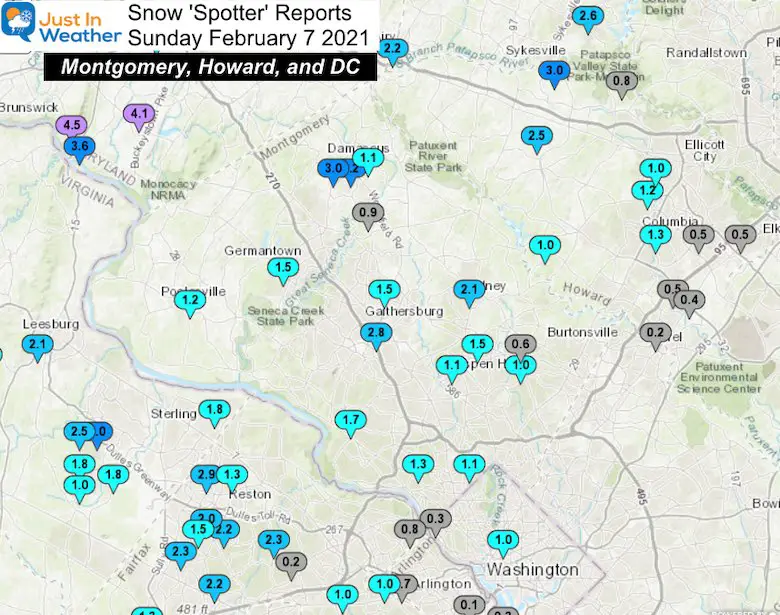
Montgomery, Howard, and Metro Washington
…Montgomery County…
- Damascus 1 S 3.2 119 PM 2/07 Trained Spotter
- Damascus 3 SSW 3.0 1157 AM 2/07 Co-Op Observer
- Rockville 3 NNW 2.8 1054 AM 2/07 NWS Employee
- Olney 1 E 2.1 1225 PM 2/07 Trained Spotter
- Potomac 1 W 1.7 800 AM 2/07 CoCoRaHS
- Norbeck 1 ESE 1.5 1230 PM 2/07 Trained Spotter
- Germantown 2 WSW 1.5 1245 PM 2/07 Trained Spotter
- Washington Grove 1 N 1.5 1158 AM 2/07 Trained Spotter
- Bethesda 1 WSW 1.3 100 PM 2/07 Trained Spotter
- Poolesville SE 1.2 800 AM 2/07 CoCoRaHS
- Aspen Hill 1 SW 1.1 100 PM 2/07 Trained Spotter
- Chevy Chase 1.1 1223 PM 2/07 Trained Spotter
- Laytonsville 5 NNW 1.1 1000 AM 2/07 CoCoRaHS
- Colesville 1.0 1044 AM 2/07 Trained Spotter
- Laytonsville 2 WNW 0.9 1150 AM 2/07 Trained Spotter
- Colesville 1 NNW 0.6 800 AM 2/07 CoCoRaHS
…Howard County…
- *Near Sykesville 2 SSE 3.0 930 AM 2/07 Trained Spotter
- Glenelg 2 N 2.5 130 PM 2/07 Trained Spotter
- Columbia 1.3 100 PM 2/07 NWS Employee
- Columbia 2 N 1.2 1100 AM 2/07 Trained Spotter
- Ellicott City 1 SW 1.0 1010 AM 2/07 Trained Spotter
- Highland 2 WNW 1.0 800 AM 2/07 CoCoRaHS
- Marriottsville 1 SE 0.8 800 AM 2/07 CoCoRaHS
- Elkridge 0.5 126 PM 2/07 NWS Employee
- Elkridge 2 W 0.5 100 PM 2/07 Trained Spotter
- Savage 1 N 0.5 930 AM 2/07 Trained Spotter
- Savage 1 ESE 0.4 1015 AM 2/07 Trained Spotter
- Laurel 1 NNE 0.2 800 AM 2/07 CoCoRaHS
…District of Columbia…
- Adams Morgan 1 ESE 1.0 1148 AM 2/07 Trained Spotter
- Dalecarlia Reservoir 0.3 800 AM 2/07 Co-Op Observer
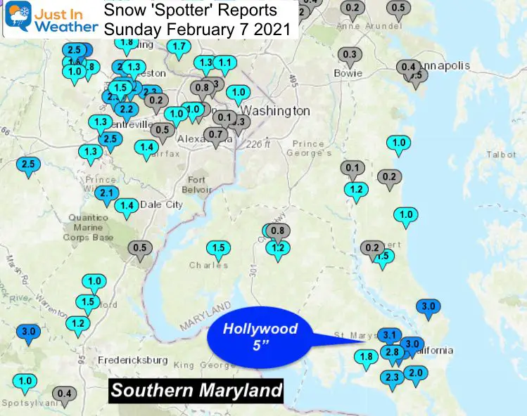
Southern Maryland
…Anne Arundel County…
- Churchton ENE 1.0 130 PM 2/07 Trained Spotter
- Pasadena 1 ENE 0.5 1030 AM 2/07 Trained Spotter
- Annapolis 1 SE 0.5 840 AM 2/07 CoCoRaHS
- Annapolis 1 NNW 0.4 1230 PM 2/07 Trained Spotter
- Crofton 2 NNE 0.3 100 PM 2/07 NWS Employee
- Severn 1 SSE 0.2 830 AM 2/07 CoCoRaHS
- BWI Airport 0.1 114 PM 2/07 Airport
…Calvert County…
- Lusby ESE 3.0 120 PM 2/07 Trained Spotter
- Prince Frederick 1 S 1.5 1230 PM 2/07 Trained Spotter
- Dunkirk 2 SSW 1.2 100 PM 2/07 Trained Spotter
- Chesapeake Beach 4 S 1.0 900 AM 2/07 CoCoRaHS
- Prince Frederick 1 W 0.2 800 AM 2/07 CoCoRaHS
- North Beach 2 WNW 0.2 800 AM 2/07 CoCoRaHS
- Dunkirk 2 NW 0.1 800 AM 2/07 CoCoRaHS
…Charles County…
- Ripley NW 1.5 1030 AM 2/07 Trained Spotter
- St. Charles 1 SSE 1.3 100 PM 2/07 Trained Spotter
- La Plata 3 ENE 1.2 155 PM 2/07 Trained Spotter
- Waldorf 3 S 0.8 930 AM 2/07 CoCoRaHS
…St. Marys County…
- Hollywood 5” from my tweeted report above
- Hollywood 3.1 100 PM 2/07 Trained Spotter
- California 3 W 3.0 130 PM 2/07 Trained Spotter
- Town Creek 1 W 3.0 1251 PM 2/07 Trained Spotter
- Hollywood 3 S 2.8 1252 PM 2/07 Trained Spotter
- Callaway 2 W 2.3 152 PM 2/07 Trained Spotter
- Great Mills 1 NNE 2.0 1145 AM 2/07 Trained Spotter
- Leonardtown 1.8 1139 AM 2/07 Trained Spotter
Delmarva:
This is hard to list. I have reports from a slushy coating to 5 inches.
My Mother In Law in Dover sent me photo proof of 4 inches there. I MUST believe that!!!!
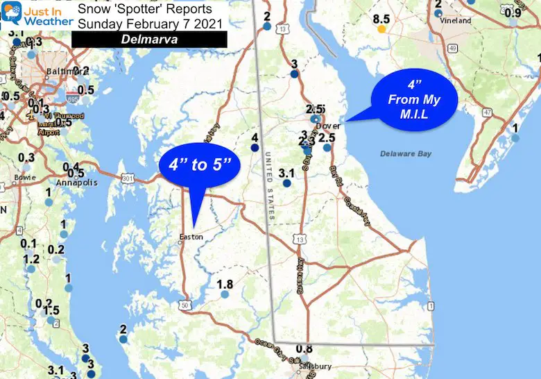
Here is a link to my Facebook post requesting other snow reports to confirm.
Request for snow reports:
❄️📏
*Southern MD
*Delmarva
Still coming down there at 2 PM…
But same issue: Big flakes with…Posted by Justin Berk, Meteorologist on Sunday, February 7, 2021
Other Storms Graded This Winter
Please share your thoughts, best weather pics/video, or just keep in touch via social media
Facebook: Justin Berk, Meteorologist
Twitter: @JustinWeather
Instagram: justinweather
Winter Outlook Series


14 Local Maryland Pages (and York PA)
We have made a page for Maryland Weather which gives you the current conditions for 14 present area locations.


FITF Shop Open
My ‘bonus’ daughter Jaiden and wife showing off our popular Maryland Hoodies. Unisex and women’s items all produced in Maryland.
Click here to see this and many other new items.

