Friday February 5 Evening Update
This is a follow up to my earlier forecast for Sunday snowfall. New updates include a look at the European and NAM KM model animation. There is more confidence in this storm doing the phasing that we initially expected earlier this week. So what was on, then off, is on again. It will be a wet snow, with some areas getting flakes falling with temps above 32ºF. But heavy rates can overtake the pavement.
This Winter Storm Watch issued by The National Weather Service is just another step in the process. Only the government agency can post these advisories, but I can say with near certainty that more will get snow that are not included here. I will show why below.
All of these areas, and others outside will be upgraded on Saturday to either a Winter Weather Advisory or Winter Storm Warning depending on final snow expectations.
NEW UPDATE SATURDAY MORNING
WINTER STORM WARNING and New Snow Maps
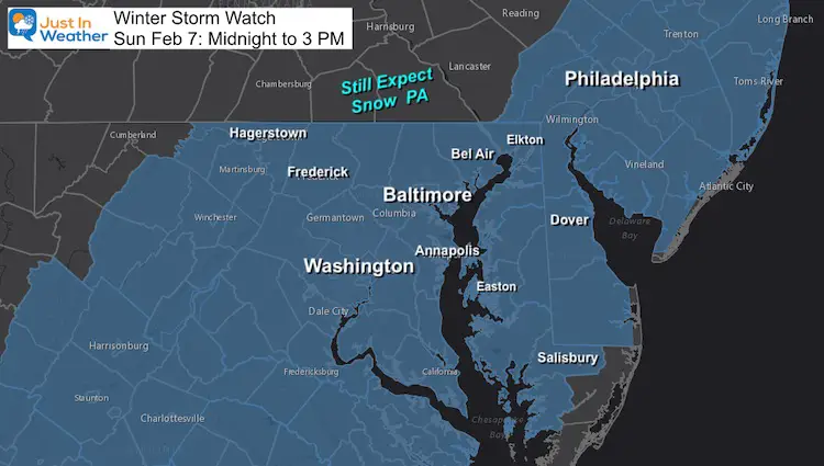
Winter Storm Watch
This is in effect from midnight to 3 PM, but the heavy snow will fall in a narrow window.
- Cecil County: Yes, this includes you!
- Southern PA: You are not in This Watch, but still expect snow on Sunday.
- Western Maryland: Expect lower accumulations.
- Beaches: You may get some snow, but will mix over to rain.
Quick Cast:
- Snow Begins: 2 AM to 6 AM.
- Snow Ends: Noon to 2 PM
- Snow: Most of the region will get a four hours of moderate to heavy snow.
- Mixing: Possible in southern MD and The Beaches
- Temperatures: From the cities, around the Bay and Delmarva will be above 32ºF. That complicated stickage and accumulation during the daylight.
Here’s a look at a few computer models simulations and the Temperatures. Then compare My Call For Snowfall to the model snow maps
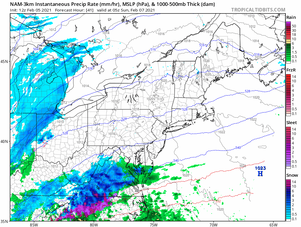
Radar Simulation ECMWF Model —-> Slider
- 2 AM to 6AM: Light snow moves in.
- 6 AM to 1 PM: Heavy snow at times. Rates could reach 1 to 2 inches per hour.
- 1 PM to 4 PM: Light snow ending.


Temperatures —-> slider
Just a simple look at: Sunrise, Evening, and Monday Morning
It can snow when above freezing and stick if it is heavy enough. Temps drop well below freezing in the evening.
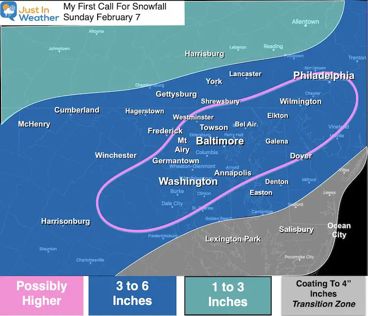
My Call For Snowfall
I purposely went lower than model guidance.
I needed to account for the ‘wet snow’ factor. This can compress accumulation AND lead to more wet roads mid day.
But there is potential for a region to get a bust of heavy snow that over a few hours can overshoot the mark.
Model Guidance
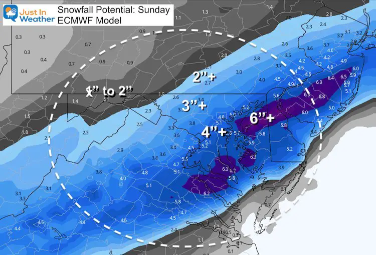
ECMWF Model
I went lower than many models shown here. But this European Model came in after my forecast and seems to be in line with my thinking.
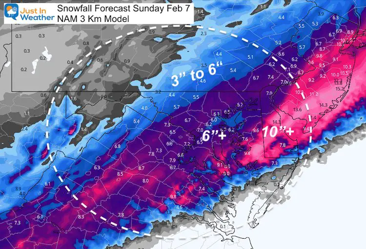
NAM 3Km
This also has very high snow across Delmarva and southern Maryland. I need to consider the more likely scenario that the verified track will be a little farther north.
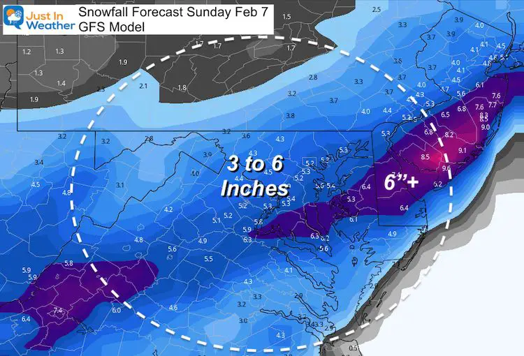
GFS Model
This seems very reasonable.
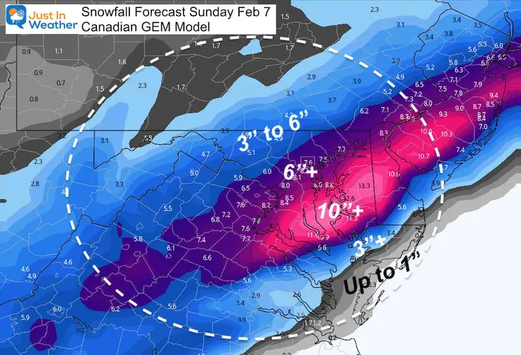
Canadian GEM
This is the most aggressive model with high totals. It was the first to show high totals for last week’s storm, but was too far south. The verification was abot 100+ miles north. It’s safe to assume that bias might occur again…
Wrap Up
- This will be a moderate hit over the first part of Sunday.
- We wake up to it, but should be able to get out by evening (for most areas that are treated)
- Evening Icing: Quick drop in temps will freeze anything wet that’ untreated.
- Monday morning: Among the coldest of the year so far…
My next Update will be Saturday Morning.
#FITF
Please share your thoughts, best weather pics/video, or just keep in touch via social media
Facebook: Justin Berk, Meteorologist
Twitter: @JustinWeather
Instagram: justinweather
Winter Outlook Series


14 Local Maryland Pages (and York PA)
We have made a page for Maryland Weather which gives you the current conditions for 14 present area locations.

FITF Shop Open
My ‘bonus’ daughter Jaiden and wife showing off our popular Maryland Hoodies. Unisex and women’s items all produced in Maryland.
Click here to see this and many other new items.

