Oh, those Miller B Storms! This was advertised as a complicated, multiple part, long duration event. Here is a brief recap and comparison of my snow forecast to many local snow spotter report maps.
I know that might be the only factor some will grade me on. But all of the events and timeline will be mentioned. I will list what I saw go right and what went wrong.
Big Winners: Frederick County, MD
BUST: Cecil County, MD
Please See The
GRADE MY FORECAST POLL
At the bottom of the snow maps and lists
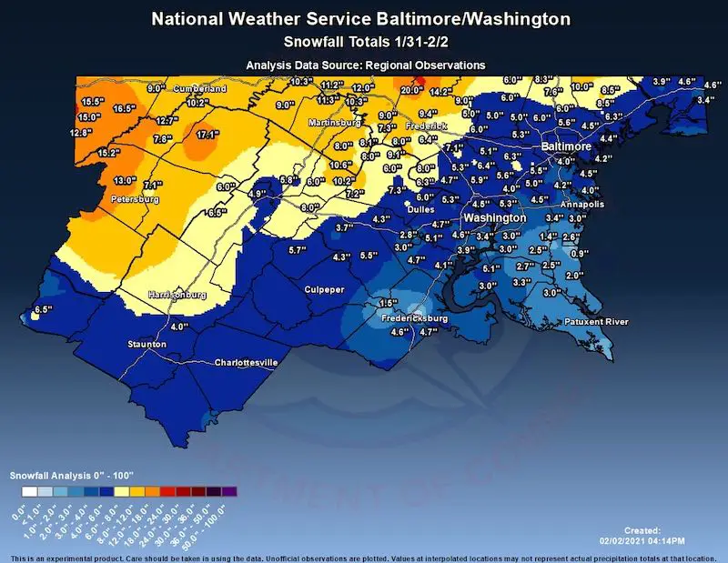
NWS Snow Total
Closer County maps and spotter lists are below
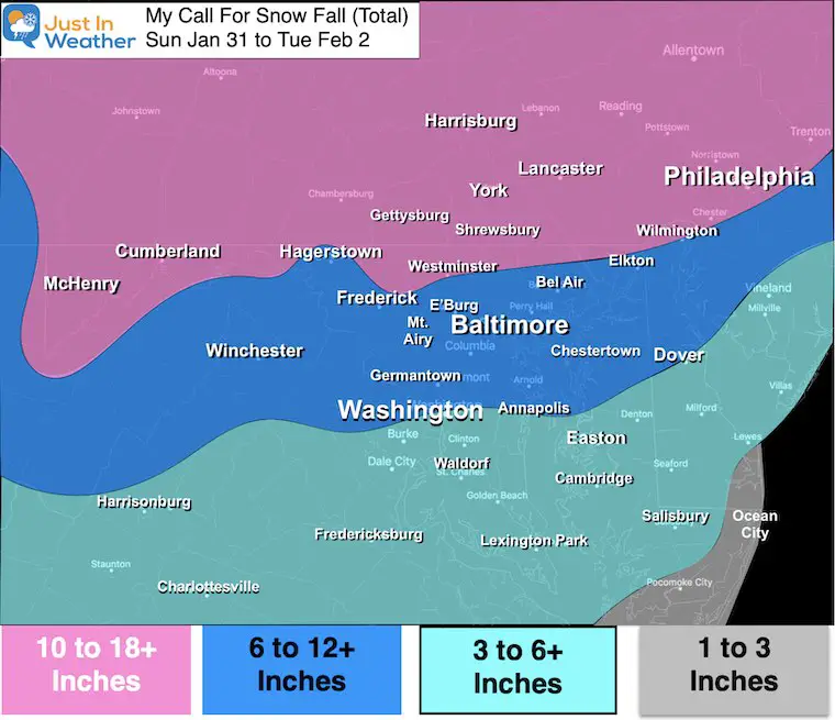
My Original (and final) Snow Forecast
Note: I mentioned an average of 3 to 6 inches of snow on Sunday. Most areas got 2.5” to 5”. That’s pretty close. But it did underperform in southern MD.
This map was for the entire Event… While many were. on the low end of the zones, they hit the zones.
Some stayed below (Cecil Co). Some went way above (northern Frederick C0.)
Quick Recap
Snow began Sunday morning brought an average of 2.5 to 5 inches to our region just that day for Part 1.
Overnight and Monday was the expected ‘Lull’ that brought freezing rain and eventually some heavy sleet to many metro areas. The ice report ranged from .25” to .50”. Then we went back to snow for the finish.
Part 2 was the expected return of snow late Monday lasting into Tuesday. In fact snow showers continued into Wednesday morning.
Overall, the storm behaved AND I maintained my confidence in the Part 2 snow, even when models (and maybe others online) suggested the storm was done.
What Went Right:
- Snow began on time Sunday.
- Snow accumulated through evening, close to or into my forecast range.
- Ice in the lull, remained for the city and inland.
- Snow returning Monday afternoon and at night. I know many doubted this, but quite a few in the northern and western Baltimore suburbs got an additional 3 to 8 inches of snow in that part.
- Mornings were icy and travel as inhibited.
What Went Wrong:
- Sunday Snow- Seemed slow and light, but it did add up all day.
- Areas did end up with 2.5” on Sunday, missing my 3” to 6” range. I heard it from a few, but many seemed to think it was on point.
- Bust (Too High): Northern Frederick County on the mountain got over 20 inches.
- Bust: Cecil County: Missed the core snow Philly got. Their totals ranged 3” to 6”. Not the 6”+ Elton south, or higher north of there.
Surface Maps: Jan 30 to Feb 3 –> slider


Closer County Maps
Spotter report lists below each map. Notice the date! If not 2/02 or 2/03, then that data is incomplete.
Southern Pennsylvania Snow
(These lists are less complete)
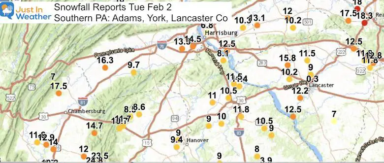
…Adams County…
- Cashtown 1 S 12.2 in 0700 AM 02/03 COOP
- Abbottstown 2.4 N 11.7 in 0700 AM 02/03 COCORAHS
- Hanover 3.5 WSW 10.1 in 0700 AM 02/03 COCORAHS
- Biglerville 3.0 WSW 8.5 in 0700 AM 02/03 COCORAHS
…York County…
- Lewsibury 11.5 in
- Red Lion 11.8 in
- Manchester 11.5 in
- Hanover 9.4 in
- Stewartstown 0.5 S 8.0 in 0700 AM 02/03 COCORAHS
...Lancaster County…
- Safe Harbor 12.5 in 0800 AM 02/03 COOP
- Lancaster 5.8 WNW 8.6 in 0700 AM 02/03 COCORAHS
Maryland Snow (West of the Chesapeake Bay)
County Break Down And Lists Below…
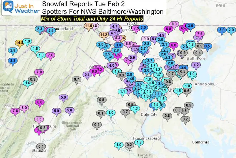
Baltimore City/County Snow
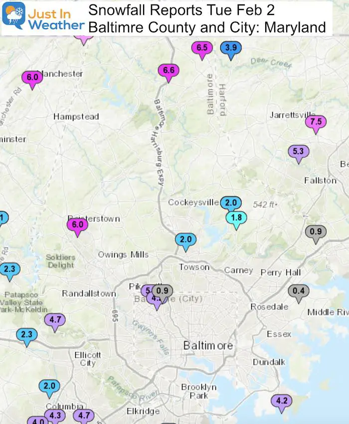
…Baltimore County…
- Bentley Springs 1 E 7.6 1030 AM 2/02 Trained Spotter
- Norrisville 3 W 6.5 700 PM 2/01 Trained Spotter
- Reisterstown 6.0 800 PM 2/01 County Emrg Mgmt
- Jacksonville 2 NE 6.0 855 AM 2/02 CoCoRaHS
- Long Green 2 NW 5.8 630 AM 2/02 Trained Spotter
- Towson 1 SW 5.6 830 AM 2/02 CoCoRaHS
- Long Green 1 SW 5.6 700 AM 2/02 CoCoRaHS
- Pimlico 1 NW 5.6 915 AM 2/02 Trained Spotter
- Glyndon 1 SW 5.0 1135 AM 2/02 Trained Spotter
- Reisterstown 1 NW 4.6 700 PM 2/01 CoCoRaHS
- Fullerton 1 N 4.5 1041 AM 2/02 Trained Spotter
- White Marsh 2 ESE 4.4 700 AM 2/02 CoCoRaHS
- Edgemere ESE 4.2 440 PM 2/01 Trained Spotter
- Upper Falls 1 NNE 3.7 1020 AM 2/02 Trained Spotter
- Kingsville 1 E 3.7 700 AM 2/02 CoCoRaHS
...Baltimore City…
- Pimlico SE 5.2 1130 AM 2/02 Trained Spotter
- Mount Washington 1 N 4.4 700 AM 2/02 CoCoRaHS
Harford and Cecil (Northeast) Snow
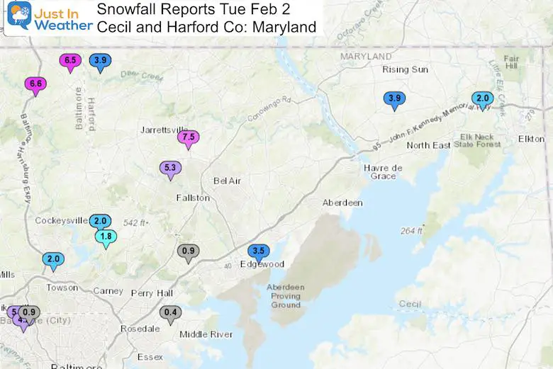
…Harford County…
- Norrisville 1 WSW 10.0 630 AM 2/02 CoCoRaHS
- Forest Hill 1 NNW 8.5 900 AM 2/02 Trained Spotter
- Chrome Hill 2 SE 8.5 900 AM 2/02 Trained Spotter
- Forest Hill 3 SW 7.1 700 AM 2/02 Trained Spotter
- Fallston 2 ESE 6.3 800 AM 2/02 CoCoRaHS
- Bel Air 2 E 5.0 1230 PM 2/02 Trained Spotter
- Kingsville 3 NNE 4.4 700 AM 2/02 CoCoRaHS
…Cecil County…
- Glen Westover 4.6 700 AM 2/02 Trained Spotter
- Elkton 5 NW 4.6 700 AM 2/02 CoCoRaHS
- Woodlawn 2 ENE 3.9 459 PM 2/01 Trained Spotter
- Elkton 1 NNW 3.4 800 AM 2/02 CoCoRaHS
Frederick and Carroll (Northwest) Snow
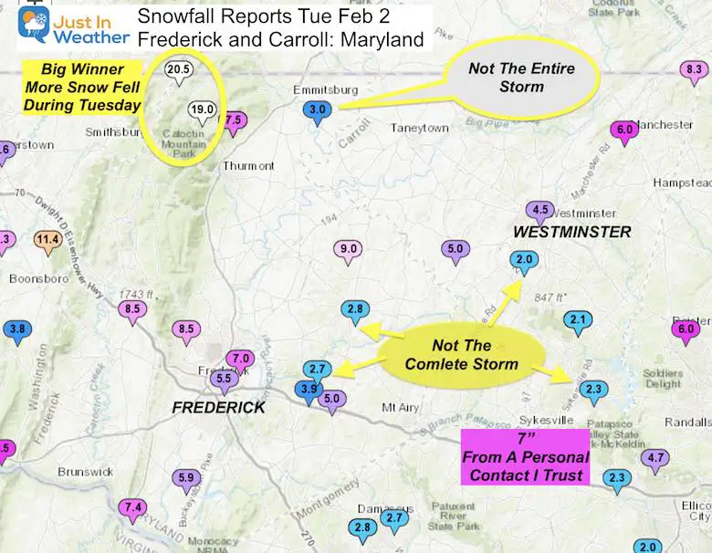
…Frederick County…
- Sabillasville 1 NNW 20.5 532 PM 2/01 CoCoRaHS
- Sabillasville 2 SSE 20.0 900 AM 2/02 Trained Spotter
- Thurmont 3 N 14.2 700 AM 2/02 CoCoRaHS
- Bloomfield 2 WSW 9.4 1100 AM 2/02 NWS Employee
- Thurmont 1 SSE 9.2 700 AM 2/02 CoCoRaHS
- Point of Rocks 1 NE 9.1 1020 AM 2/02 Trained Spotter
- Pleasant Walk 1 SW 9.0 1200 PM 2/02 Trained Spotter
- Woodsboro 3 E 9.0 513 PM 2/01 Trained Spotter
- Myersville 2 SE 8.5 700 PM 2/01 Trained Spotter
- Emmitsburg 2 SE 8.0 610 AM 2/02 Co-Op Observer
- Point of Rocks 2 N 8.0 1000 AM 2/02 Trained Spotter
- Frederick 1 ENE 7.0 700 PM 2/01 Trained Spotter
- New Market 3 NNW 6.7 715 AM 2/02 CoCoRaHS
- New Market 2 NW 6.6 915 AM 2/02 CoCoRaHS
- Adamstown 1 ESE 6.4 1200 PM 2/02 Trained Spotter
…Carroll County…
*I have have many reports send to me directly that were higher than these.
- Millers 4 NE 8.3 1200 AM 2/02 Co-Op Observer
- Westminster SE 6.0 805 AM 2/02 Trained Spotter
- Mount Airy SE 6.0 730 AM 2/02 CoCoRaHS
- Manchester 6.0 547 PM 2/01 County Emrg Mgmt
- Sykesville 6 NNW 5.5 800 AM 2/02 CoCoRaHS
- Westminster 3 SSW 5.0 700 AM 2/02 CoCoRaHS
- Marston 2 NNW 5.0 530 PM 2/01 NWS Employee
- Gamber 1 W 4.8 700 AM 2/02 CoCoRaHS
- Gamber 1 WNW 4.8 700 AM 2/02 NWS Employee
- Eldersburg 1 E 4.6 700 AM 2/02 CoCoRaHS
*Eldersburg I know for sure had at least 7 inches. A close friend reported that with multiple photos to confirm.
Washington Co (Mountains) Snow
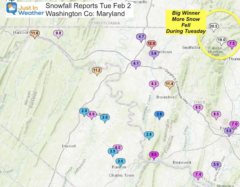
...Washington County…
- Boonsboro 3 NNE 12.3 1100 AM 2/02 Trained Spotter
- Long Meadow 1 SSE 12.0 408 PM 2/01 Trained Spotter
- Hagerstown 1 ENE 10.7 700 AM 2/02 CoCoRaHS
- Hagerstown 4 NNW 10.4 700 AM 2/02 CoCoRaHS
- Pecktonville 3 NNW 10.3 715 AM 2/02 Trained Spotter
- Williamsport 3 ENE 10.3 600 AM 2/02 CoCoRaHS
- Long Meadow 2 W 10.2 730 AM 2/02 Trained Spotter
- Keedysville 2 SSE 8.0 700 AM 2/02 CoCoRaHS
- Sharpsburg 5 S 7.3 700 AM 2/02 Co-Op Observer
Western Maryland Snow
Some of these reports were the final 24 hours and not the complete event.
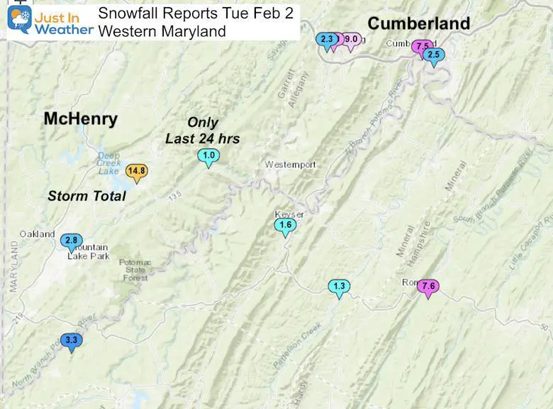
…Garrett County…
- Deer Park 6 NE 16.5 700 AM 2/02 Trained Spotter
- McHenry 1 S 15.5 700 AM 2/02 Trained Spotter
- McHenry 5 SSE 15.0 800 AM 2/02 CoCoRaHS
- Mountain Lake Park 12.8 600 AM 2/02 CoCoRaHS
…Allegany County…
- Frostburg 2 ENE 10.5 1010 AM 2/02 Trained Spotter
- Cresaptown-Bel Air 1 10.2 700 AM 2/02 CoCoRaHS
- Frostburg 9.0 700 AM 2/02 Co-Op Observer
- Ridgeley 1 NW 7.5 1004 PM 2/01 Trained Spotter
Montgomery, Howard, and Washington DC Snow

...Montgomery County…
- Poolesville SE 8.0 800 AM 2/02 CoCoRaHS
- Damascus 3 SSW 7.1 1258 PM 2/02 Co-Op Observer
- Laytonsville E 6.4 700 AM 2/02 CoCoRaHS
- Rockville 3 NNW 5.9 1047 AM 2/02 NWS Employee
- Colesville 1 NNW 5.6 800 AM 2/02 CoCoRaHS
- Silver Spring 5.5 930 AM 2/02 County Emrg Mgmt
- Norbeck 1 ESE 5.4 945 AM 2/02 Trained Spotter
- Germantown 2 WSW 5.3 1120 AM 2/02 Trained Spotter
- Takoma Park 1 NNW 5.3 700 AM 2/02 CoCoRaHS
- Colesville 2 W 5.0 700 AM 2/02 CoCoRaHS
- Clarksburg 1 SSE 4.8 1200 AM 2/02 CoCoRaHS
- North Potomac 4 N 4.7 700 AM 2/02 CoCoRaHS
- Laytonsville 5 NNW 4.7 700 AM 2/02 CoCoRaHS
- Potomac 1 NNW 4.6 700 AM 2/02 CoCoRaHS
- Montgomery Village 1 4.5 630 AM 2/02 CoCoRaHS
- Rossmoor 1 ESE 4.3 700 AM 2/02 CoCoRaHS
- Rockville 1 SSE 4.2 1200 PM 2/02 Trained Spotter
- Bethesda 1 NNW 4.0 903 AM 2/02 Trained Spotter
- White Oak 1 N 4.0 700 AM 2/02 CoCoRaHS
- Gaithersburg 3 NE 3.8 700 AM 2/02 CoCoRaHS
…Howard County…
- Simpsonville E 6.5 1100 AM 2/02 Trained Spotter
- Simpsonville 2 NNW 6.3 1106 AM 2/02 Trained Spotter
- Simpsonville 1 SSE 6.2 800 AM 2/02 Trained Spotter
- Elkridge 2 W 6.2 100 PM 2/02 Trained Spotter
- Historic Ellicott Ci 6.0 954 AM 2/02 Trained Spotter
- Columbia 5.8 1100 AM 2/02 NWS Employee
- Savage 1 N 5.5 1000 AM 2/02 Trained Spotter
- Marriottsville 1 SE 5.3 800 AM 2/02 CoCoRaHS
- Elkridge 5.3 1046 AM 2/02 NWS Employee
- Sykesville 2 SSE 5.3 700 AM 2/02 CoCoRaHS
- Columbia 2 N 5.1 700 AM 2/02 CoCoRaHS
- Glenelg 2 N 5.1 1200 PM 2/02 Trained Spotter
- North Laurel 2 ESE 5.0 730 AM 2/02 CoCoRaHS
- Granite 1 SSE 4.7 1145 PM 2/01 Trained Spotter
- Marriottsville 3 S 4.7 700 AM 2/02 CoCoRaHS
- Columbia 2 NE 4.5 800 AM 2/02 Trained Spotter
- Laurel 1 NNE 3.8 700 AM 2/02 CoCoRaHS
DISTRICT OF COLUMBIA
- …District of Columbia…
- American University 4.5 1119 AM 2/02 Trained Spotter
- Washington 3 NE 4.2 800 AM 2/02 CoCoRaHS
Anne Arundel and PG
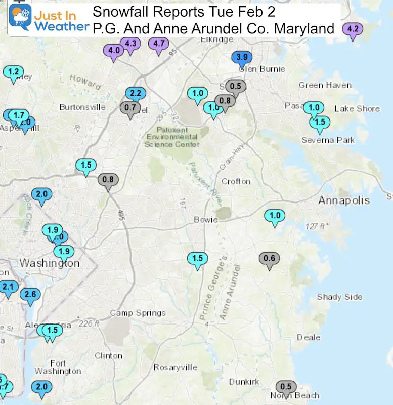
…Anne Arundel County…
- Crofton 4.5 700 AM 2/02 NWS Employee
- Chelsea Beach NNE 4.5 715 AM 2/02 Trained Spotter
- Odenton 1 N 4.2 700 AM 2/02 CoCoRaHS
- Pasadena 3 ESE 4.0 800 AM 2/02 CoCoRaHS
- Bwi Airport 4.0 100 PM 2/02 Airport
- Severn 2 W 4.0 700 AM 2/02 CoCoRaHS
- Crofton 1 SSE 4.0 1138 AM 2/02 NWS Employee
- Severn 2 SSW 3.8 817 AM 2/02 CoCoRaHS
- Severn 1 SSE 3.7 800 AM 2/02 CoCoRaHS
- Annapolis 1 SE 3.5 430 AM 2/02 CoCoRaHS
- Birdsville WSW 3.4 700 AM 2/02 CoCoRaHS
- Glen Burnie 1 WSW 3.4 900 AM 2/02 Trained Spotter
- Severn 2 E 3.3 730 AM 2/02 CoCoRaHS
- Riva 1 NNW 3.0 745 AM 2/02 CoCoRaHS
- Birdsville 3.0 700 AM 2/02 NWS Employee
…Prince Georges County…
- Bowie 4 S 3.5 700 AM 2/02 CoCoRaHS
- Greenbelt 1 N 3.2 800 AM 2/02 CoCoRaHS
- Fort Washington 1 SS 3.0 700 AM 2/02 CoCoRaHS
- Oxon Hill 1 SW 3.0 700 AM 2/02 Co-Op Observer
- Oxon Hill 1 W 3.0 700 AM 2/02 CoCoRaHS
- Brandywine 7 ESE 2.5 700 AM 2/02 CoCoRaHS
GRADE MY FORECAST
Poll Open until 7 PM Thursday February 4
I will post results online after complete.
My take:
B
- I understand an A in northern Maryland, the mountains, and maybe southern PA.
- I can see a C or D in Cecil County and some of southern Maryland.
Please add any additional comments on the social media post where you saw this article.
Grader My Forecast: Jan 31 to Feb 2 2021
- A (Thanks) (53%, 1,813 Votes)
- B (33%, 1,139 Votes)
- C (10%, 359 Votes)
- D (3%, 91 Votes)
- F (come on, really?) (1%, 23 Votes)
Total Voters: 3,425
Please share your thoughts, best weather pics/video, or just keep in touch via social media
Facebook: Justin Berk, Meteorologist
Twitter: @JustinWeather
Instagram: justinweather
Maryland Weather Page
I wanted to keep it simple. Just the basics for a quick view at any time.

Winter Weather Resource Pages
Click Here For My Complete Winter Resource Info
Winter Outlook Series


14 Local Maryland Pages (and York PA)
We have made a page for Maryland Weather which gives you the current conditions for 14 present area locations.

FITF Shop Open
My ‘bonus’ daughter Jaiden and wife showing off our popular Maryland Hoodies. Unisex and women’s items all produced in Maryland.
Click here to see this and many other new items.


Also see:
Just In Power Kids:
A portion of proceeds go to our programs Providing FREE holistic care for kids in cancer treatment and up to 5 years post treatment and caregivers.
![]()
New Caps and Hats

