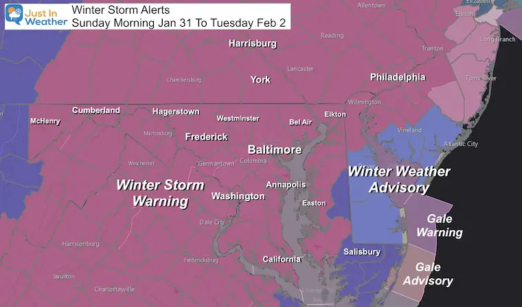
Sunday January 31 at 5 PM
After what many have deemed a slow start this morning, snow has evolved and expanded this afternoon. It may have seemed light, but most areas should hit the expected snow for today (3″+) before any change over.
At 5 PM The National Weather Service Snow Report:
- Baltimore at BWI = 2.3″ (almost doubling our seasonal total)
- Washington (National) = 1.7″
- Washington (Dulles) = 2.2″
This is a long duration 2-part event. That means it is spread out, then will come to an end on Tuesday. There is more to go. This evening there will be a change over to sleet moving north. Large flakes possible before the sleet and freezing rain. Then we return with the coastal storm on Monday.
We are still under a Winter Storm Warning, but there could be a few hours or more where it seems like not much is happening.
I want to address the analysis this afternoon, change over this evening, and Part 2 snow with the Coastal Low Monday.
At the bottom, I have an explanation for the Snowflake Sprinkles this morning,
The short story: I AM NOT CHANGING MY SNOW FORECAST.
Please recall my forecast breakdown:
- Today = Part 1: Snow 3 to 6 inches by evening.
- Tonight: Mixing and lull.
- Monday is Part 2: Snow returns mid day and afternoon. May be heavy at times with stronger winds. Additional Accumulation.
- Tuesday: Snow showers end as the storm moves away.
THEN We measure the FINAL TOTAL
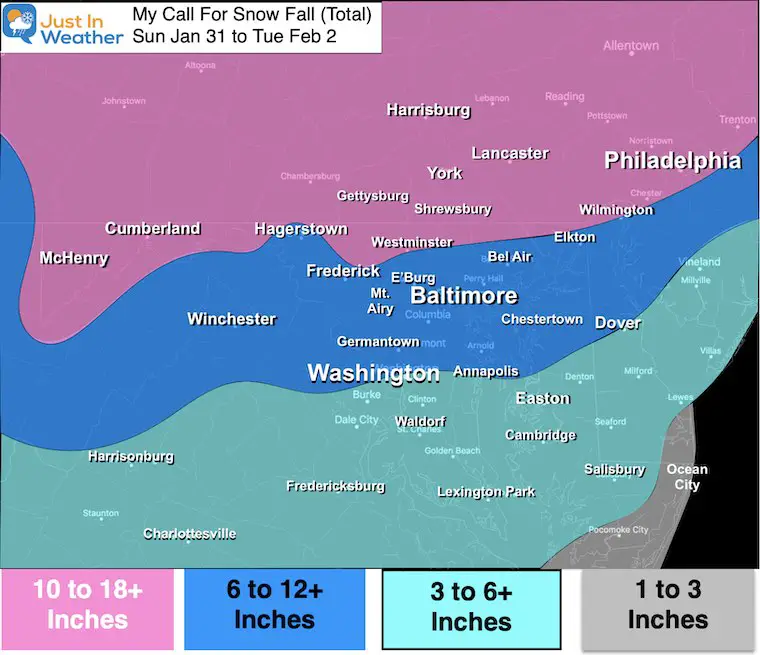
I will post my call for snowfall map again with the new model snow maps below.
Afternoon Set Up
Doppler Radar
Snow has appeared to fill in the bands and intensify this afternoon. The energy has come in waves with bands of heavy snow, and lulls in between.
But the sleet and freezing rain is advancing north, as expected. At 5 PM this had reached south of Washington at the Pentagon and southern Maryland.
Note: Flakes may appear to grow larger right before the change to sleet. That is due to warmer air at cloud level partially melting the edges of flakes, and then they stick together to come down in clumps.
A ‘thump’ of snow is possible for a quick additional inch before a change in your area around the Bay.

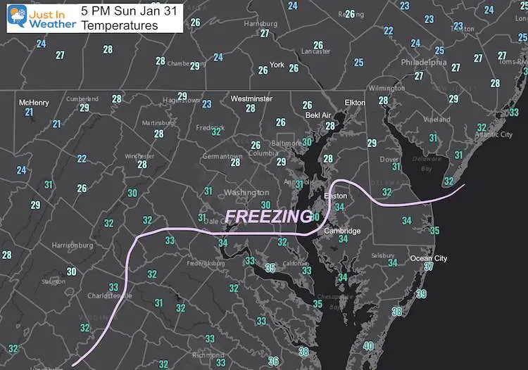
Temperatures
The Freezing Line has reached Easton and southern Maryland. Upper 20s seems to be holding tight around metro Baltimore, central Maryland, and into the mountains/southern PA.
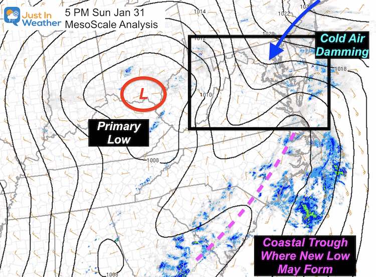
Mesoscale Surface Map
The Primary Surface Low has been passing through southern Ohio. As it gets closer and compresses up agains the Cold Dome in New England, there has been more lift in the atmosphere to enhance the snowfall.
This is also allowing the warmer air from the south to move north up the Bay.
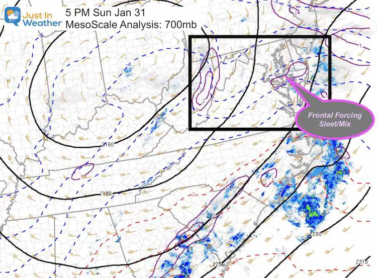
Mesoscale Cloud Level
850mb to 700mb Map (around 3,000 Ft)
This is called Frontotgenesis, where we can see developing boundaries at cloud level.
Evening: Mixing From Snow To Sleet And Rain
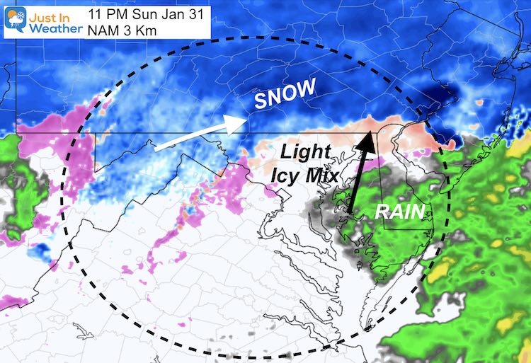
NAM 3 Km
Around 8 PM (wiggle room of 2 hours) the mixing should be spreading through Washington and Baltimore. At that time Annapolis should be rain, with snow lingering in the far northern suburbs.
By this point most of the region should have reached or be close to the Part 1 snow total of 3”+
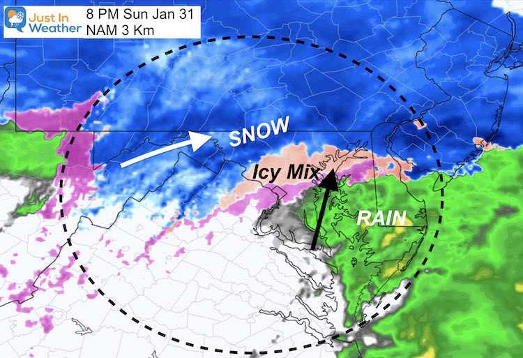
By 11 PM we can see the snow line retreating north of Frederick to the Pennsylvania line.
Monday Morning
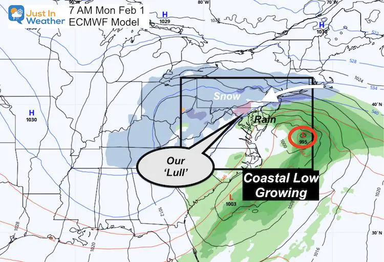
The tough part of this is forecasting a storm that has not formed yet. That is what tomorrow is all about.
- This will be in the ‘Lull’ as the Coastal Storm takes over.
- A light mix or even a few dry hours may appear as if the storm is over.
- We will watch for that coastal Low to intensity and pull back closer to the coast.
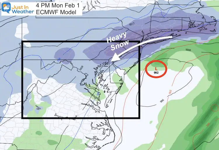
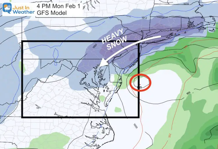
Afternoon and Evening Snow Returns
I expect the snow to return between 10 AM and 4 PM
Why such a large window? Because we are talking about a storm that has not formed yet, not knowing exactly where it will be. A wobble of 50 to 100 miles can make a big difference in the arrival and intensity.
We will get snow and strong winds, but the models do differ.
European
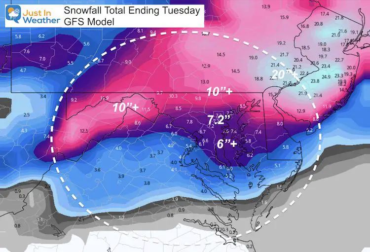
GFS Model
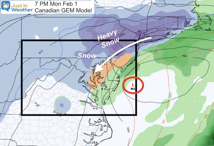
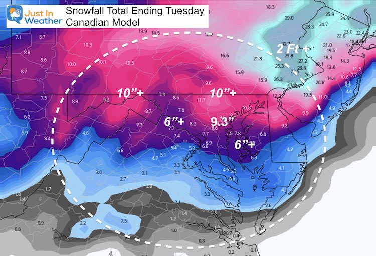
Canadian GEM Model
This model has been the outlier. Here it brings the Low closest to the coast, but pushes the heaviest snow north of Philadelphia. At that time it keeps the warmer air and icy mix here a little longer. Then changing over by evening.
Just because this model shows it, doesn’t mean it will happen. I simply want to compare all the options.
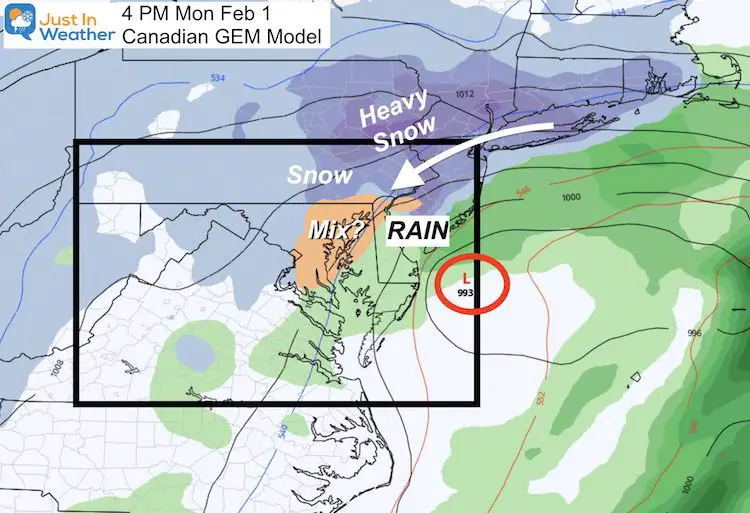
Evening: Moderate to heavy snow reaches I-95. But mixing takes longer too return to snow on the bay. It will turn to all snow overnight before ending.
How Much Snow:
I know some of you have seen the models or other bloggers talking about the shift of the heavy snow northeast. I am not worried about that. I have stayed with my snow forecast and it remains. Even a pull back of snow on the models, still fits in with my consistent forecast. Compare here:
My Forecast
Still The Same. We have mostly reached the 3″ I expected to this point.
European Model
This still fits with my forecast…
GFS Model
This still fits with my forecast…
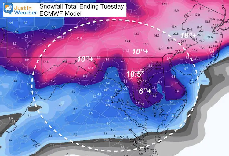
Canadian Model
(This was always the highest and I felt too high) That bullseye shifted to The Poconos.
My Forecast Timeline Highlight List
Sunday Morning:
- First flakes will arrive between 6 AM and 11 AM. This may rain into dry air, and appear on radar for a few hours before reaching the ground (virga).
- Flakes will be light and powdery at the start.
Sunday Afternoon:
- Moderate to Heavy snow. Much of the region will get 3 to 6 inches by sunset.
- Flakes get heavier/wetter and more slushy before the mixing.
Sunday Evening:
- Rain begins to advance north up the Bay.
- Cities will mix with sleet and freezing rain between 6 PM and midnight.
- Still snow on norther counties.
Sunday Night- Monday Morning
- Lull in the action as the coast Low takes over.
- Light mix or rain for cities.
- Mix or light snow north.
Monday Afternoon/Evening:
- Snow Returns.
Monday Night:
- Snow will be heavy at times. This may be the peak of the storm!
- Flakes gradually turn lighter/dryer due to colder air aloft.
- Winds may gust to 35 mph overnight, making for near blizzard conditions. Midnight to Tuesday morning snow will be blowing around reducing visibility and covering over some roads faster after being treated.
Winds:
- The coastal Low will crank and be in full effect Monday night.
- Steady winds 15 to 20 mph may gust to 35 mph. This will bring near blizzard conditions at times.
Tuesday:
- Snow tapers to snow showers and flurries by mid day. Blowing snow may cover treated roads.
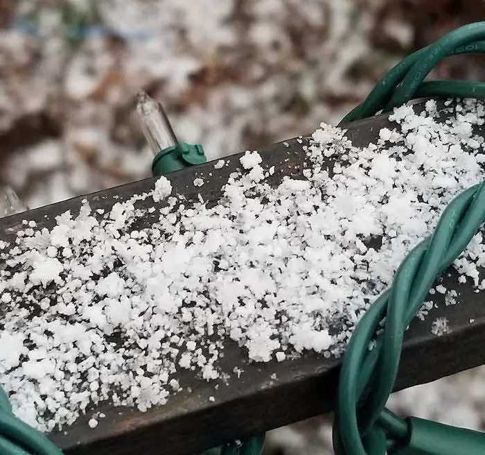
Snowflake Sprinkles
This was the common question I was getting at the start: Why are the snowflakes like this?
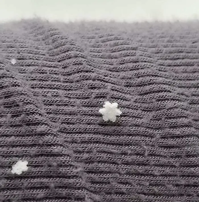
My friend Katie Hancock sent these from Westminster, MD and I got many more like it. Did you see them?
She asked why these perfectly shaped snowflakes appears like this, solid.
The best I can explain is all based on the dry air aloft. It caused the edges to sublimate, but not completely. As the atmosphere cooled, there was a flash freeze and the flakes solidified quickly.
It was like ‘Shrinky-Dinks” some of us played with as kids. The flakes shrunk, condensed, and froze in a smaller, thick, solid form.
Please share your thoughts, best weather pics/video, or just keep in touch via social media
Facebook: Justin Berk, Meteorologist
Twitter: @JustinWeather
Instagram: justinweather
Winter Weather Resource Pages
Click Here For My Complete Winter Resource Info
Winter Outlook Series


14 Local Maryland Pages (and York PA)
We have made a page for Maryland Weather which gives you the current conditions for 14 present area locations.

FITF Shop Open
My ‘bonus’ daughter Jaiden and wife showing off our popular Maryland Hoodies. Unisex and women’s items all produced in Maryland.
Click here to see this and many other new items.


Also see:
Maryland Weather Page
I wanted to keep it simple. Just the basics for a quick view at any time.

Just In Power Kids:
A portion of proceeds go to our programs Providing FREE holistic care for kids in cancer treatment and up to 5 years post treatment and caregivers.
![]()
New Caps and Hats

