January 30 2021
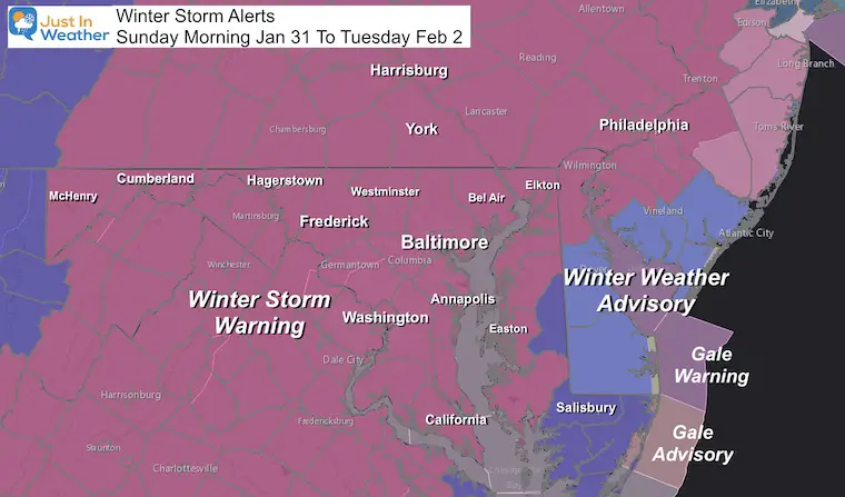
Winter Storm Warnings were upgraded across much of the area this afternoon. This confirms the reality of a moderate to high impact snow event. This will be out biggest winter storm in 5 years, so many are out of practice. What is important to note is that this will spread over a few days.
Here is a simplified timeline breakdown, a snow and rain forecast animation, and the latest model snow maps.
Winter Storm Warning
Most of our region is expecting a moderate to heavy snow event Sunday morning to Tuesday.
The Winter Weather Advisory (blue) on Delmarva is for less snow, but they will have problems with stronger winds.
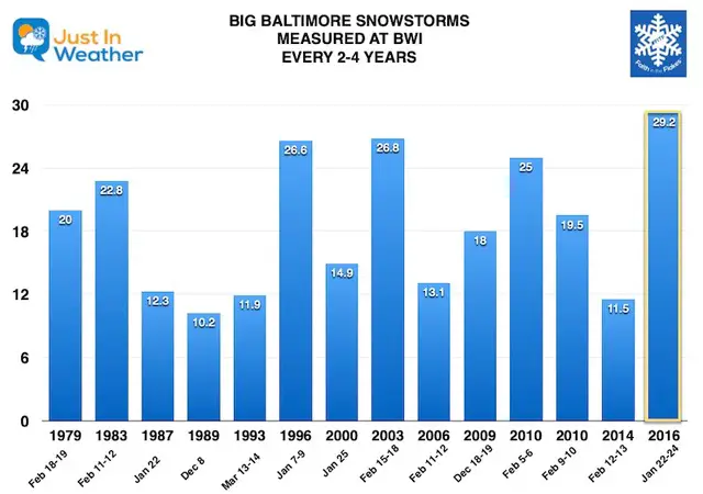
Biggest Storm In 5 Years: May Keep The Pattern
This will be the largest snow event since our record 29.2 inch storm in January of 2016.
We had a pattern of a large storm in Baltimore (over 10 inches of snow) every 2 to 4 years since the 1970s. Missing last year (2020), we are overdue!
This storm has the potential to be added to our chart here, we would just have to edit the title.
Click the chart to see my full Baltimore Snow History Data
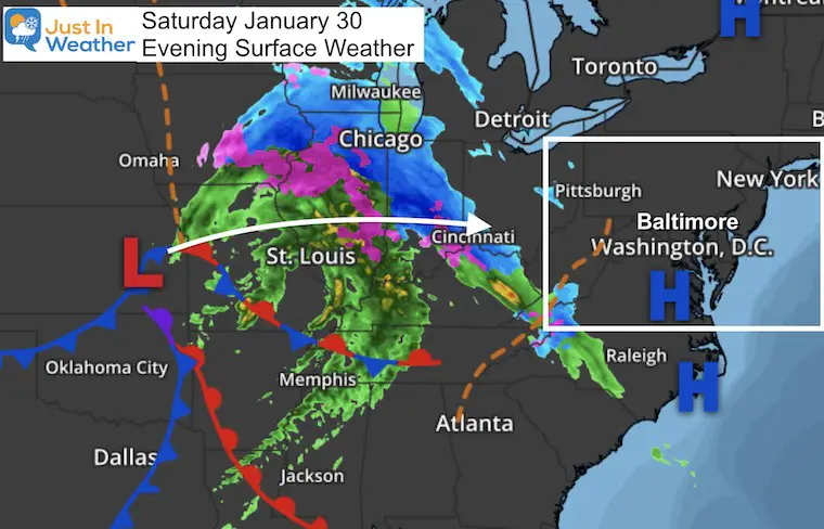
Saturday Evening Weather Map
The Primary Low Pressure is just west of Kansas City and already has a wide expanse of snow and ice well ahead of it.
As we discussed in prior posts, this will eventually transfer its energy to a new Coastal Low on Monday. Before that happens, we will get the leading edge of snow to arrive Sunday morning.
Storm Highlights
This list will be follow by maps, then the storm animation.
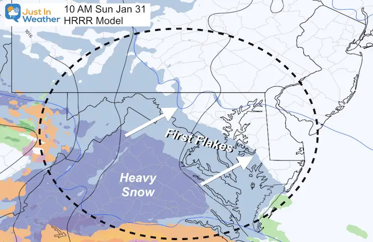
Sunday Morning:
- First flakes will arrive between 6 AM and 11 AM. This may rain into dry air, and appear on radar for a few hours before reaching the ground (virga).
- Flakes will be light and powdery at the start.
Sunday Afternoon:
- Moderate to Heavy snow. Much of the region will get 3 to 6 inches by sunset.
- Flakes get heavier/wetter and more slushy before the mixing.
Sunday Evening:
- Rain begins to advance north up the Bay.
- Cities will mix with sleet and freezing rain between 6 PM and midnight.
- Still snow on norther counties.
Sunday Night- Monday Morning
- Lull in the action as the coast Low takes over.
- Light mix or rain for cities.
- Mix or light snow north.
Monday Afternoon/Evening:
- Snow Returns.
Monday Night:
- Snow will be heavy at times. This may be the peak of the storm!
- Flakes gradually turn lighter/dryer due to colder air aloft.
- Winds may gust to 35 mph overnight, making for near blizzard conditions. Midnight to Tuesday morning snow will be blowing around reducing visibility and covering over some roads faster after being treated.
Winds:
- The coastal Low will crank and be in full effect Monday night.
- Steady winds 15 to 20 mph may gust to 35 mph. This will bring near blizzard conditions at times.
Tuesday:
- Snow tapers to snow showers and flurries by mid day. Blowing snow may cover treated roads.
Now Let’s Add In Some Maps
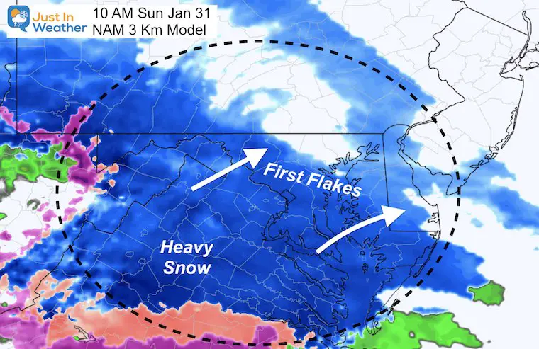
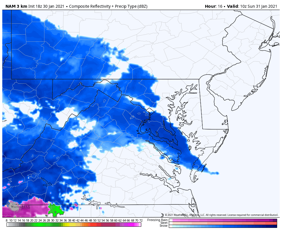
Sunday Morning:
This HRRR Model is a little slower than the NAM 3Km for the first flakes. Consider a wide window for when the snow may break through the dry air and reach the ground.
Southern PA might start a few hours later.
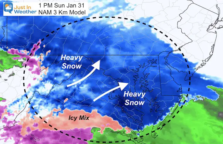
Sunday Afternoon
Moderate to heavy snow builds in across most of our region.
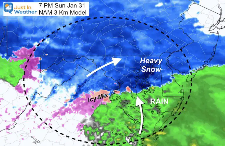
Sunday Evening
Rain begins to spread in from south to north.
Moderate to heavy snow in central Maryland to southern PA.
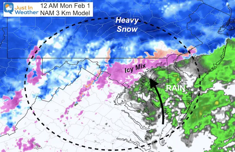
Midnight- Monday
- This is when the icy mix is expected in the cities and I-95 corridor.
- Rain Annapolis to Delmarva.
- Snow may linger in southern PA.
LULL:
There may be little to no activity overnight into Monday. This will be as the coastal storm develops.
The return of heavy snow is all based on that second Low actually getting pulled back west to the coast.
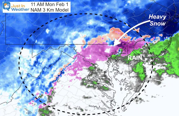
Monday Morning
Same set up with rain south, mix in the cities, and snow north.
Heavy Snow is likely north of Philadelphia. If that coastal Low does its thing, this is when it will move back our way and drag in colder air.
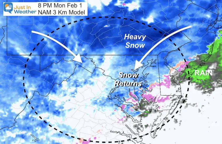
Monday Evening
This will be the BOOM or BUST time! The coastal Low should back our way with heavy snow and strong winds.
This could bring the heaviest snow of the entire event, lasting overnight.
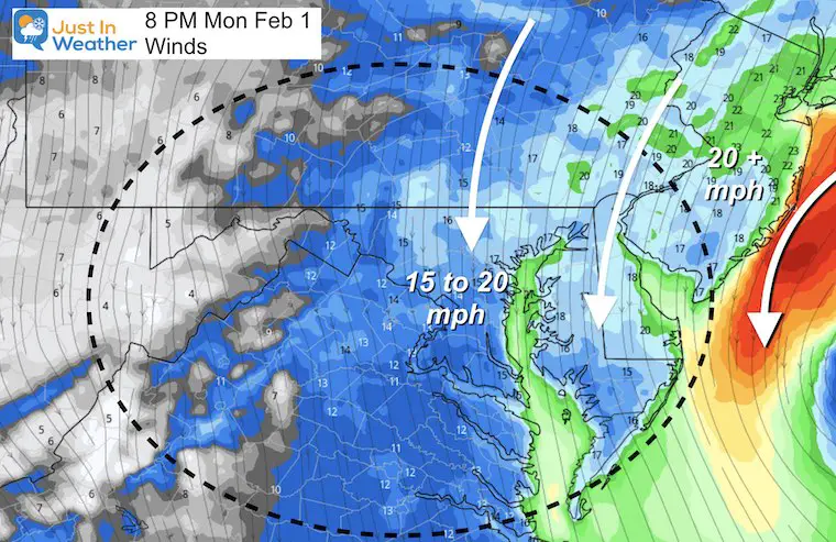
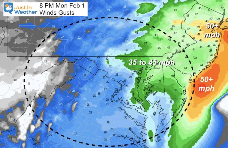
Monday Night Winds
Steady winds from the north over 15 mph. Much stronger on the coast with the Gale Warning!
Wind gusts could reach 35 mph with our heavier snow. That would be near Blizzard Conditions and white out at times.
Put This All into Motion
Storm Animation NAM 3Km Model
Sunday 5 AM to Tuesday 1 AM
This is NOT to the end of the event.
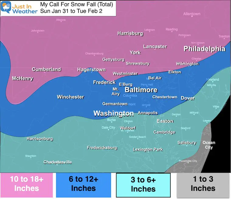
How Much Snow:
Compare My Forecast To New Computer Models
My First Call For Snow Remains
Bust potential: I played it cautious.
If the Coastal Low is strong enough, we could end up higher. That is why I added the + to the high end number.
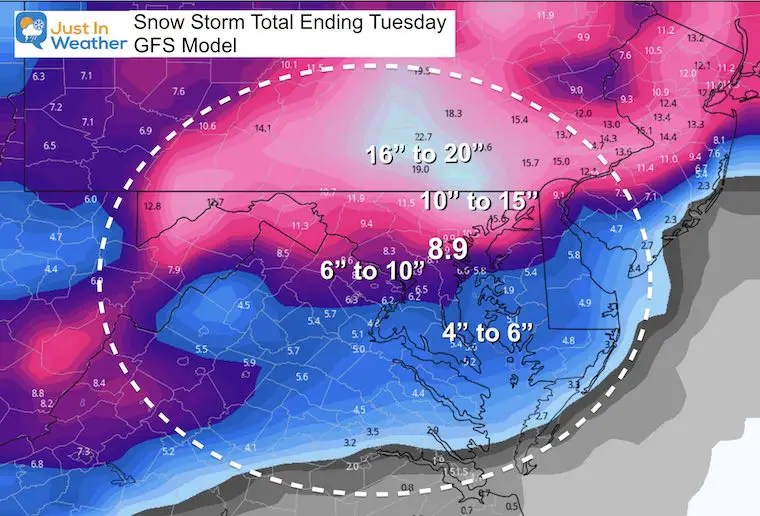
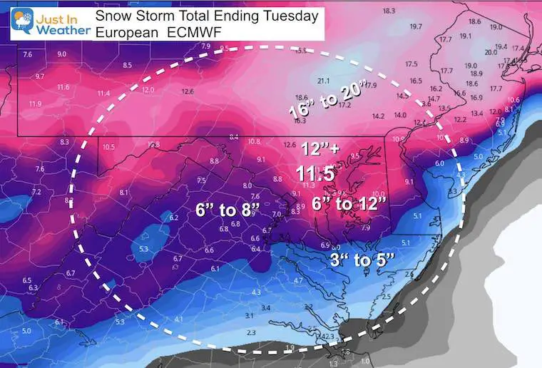
Latest Computer Model Snow Forecasts
GFS Model: Lowest Snow
European Model
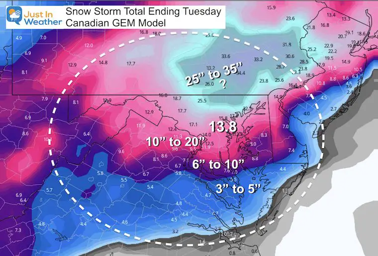
Canadian Model: Highest Snow!
What is the GEM seeing? It remains the highest with snow and keeps increasing the totals in the BOOM ZONE. That could include northern Maryland and southern PA if it verifies. That is a BIG IF!
Quick Notes:
- I hope this helped to break down when to expect for your region.
- Snow builds on Sunday and we all get accumulation through evening.
- The Evening and overnight will bring a warming mix to the cities, and a lull in activity. That lull may last into Monday morning or early afternoon.
- Monday night may bring the heaviest snow and strongest winds.
- My original forecast is holding.
- If there is a BUST, it would more likely be with more snow. But there is a small chance that coastal stays farther away and we miss the Monday night surge.
Please share your thoughts, best weather pics/video, or just keep in touch via social media
Facebook: Justin Berk, Meteorologist
Twitter: @JustinWeather
Instagram: justinweather
Winter Weather Resource Pages
Click here if the tiles do not appear
Winter Outlook Series


14 Local Maryland Pages (and York PA)
We have made a page for Maryland Weather which gives you the current conditions for 14 present area locations.

FITF Shop Open
My ‘bonus’ daughter Jaiden and wife showing off our popular Maryland Hoodies. Unisex and women’s items all produced in Maryland.
Click here to see this and many other new items.


Also see:
Maryland Weather Page
I wanted to keep it simple. Just the basics for a quick view at any time.

Just In Power Kids:
A portion of proceeds go to our programs Providing FREE holistic care for kids in cancer treatment and up to 5 years post treatment and caregivers.
![]()
New Caps and Hats

