January 22 2021
The first winter weather event early next week appears to be set up to arrive Monday afternoon and last into Tuesday. After our cold weekend, the ground should be sufficiently chilled to accommodate stickage or ice. But as warmer air bumps up and over our chilly air mass, there will be a mix of wintry precipitation.
Monday Arrival Of Winter Storm
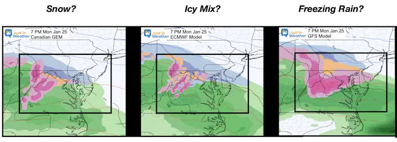
This comparison of our three main models shows the split in theories. They all support mostly a freezing rain/ice event. The start is where they differ.
What falls and reaches the ground will depend on how deep the layer of cold air is when the storm arrives.
- Canadian is coldest with a few hours of snow.
- European is the middle of the road with a snow mix.
- GFS has our region with mostly freezing rain.
Compare The Model Timelines
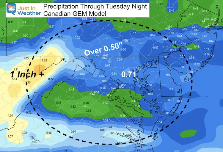
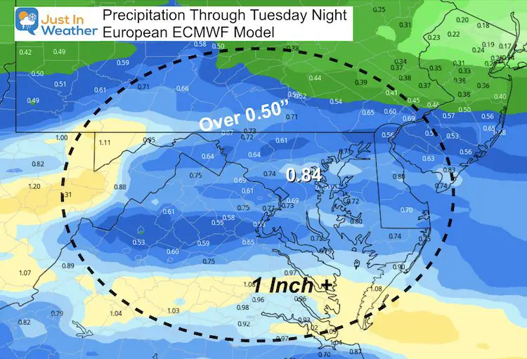
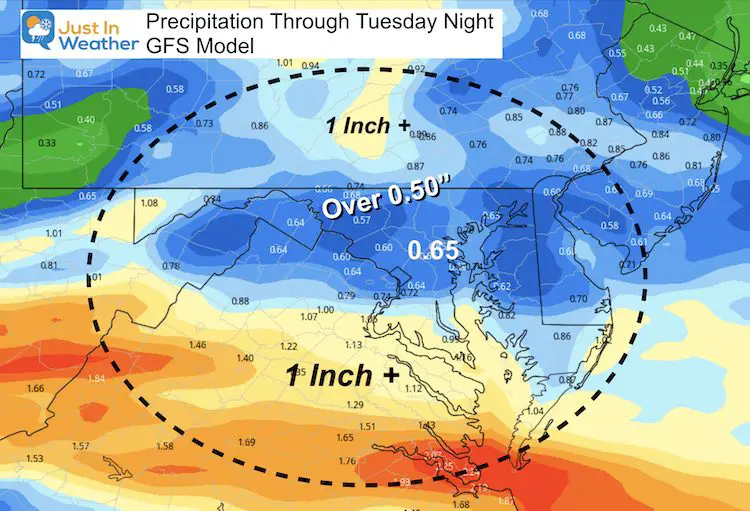
Here is a brief look at the three model timelines. There is window between Monday afternoon and evening for the arrival, but the bulk of the event shows mostly freezing rain. We need to focus not only how cold it remains on Monday, but how deep that cold layer is to allow snow, sleet, or freezing rain.
Canadian GEM Model —-> slider


How much ice?
Forecast Precipitation for the event, but this does not determine snow, ice or rain.
European ECMWF Model —-> slider
How much ice?
Forecast Precipitation for the event, but this does not determine snow, ice or rain.
GFS (American) Model —-> slider
How much ice?
Forecast Precipitation for the event, but this does not determine snow, ice or rain.
What About Temperatures?
I am not showing the temperature forecast at this time because I do not trust any of them.
There are too many variables that need to be considered:
- How deep will the cold air be? An inversion will develop with this storm set up. That is where temperatures turn warmer with height.
- What will the wind direction be? That can help determine is there will be any warming near the water, and if so how much?
- Cold Air Dams like this often hold longer than models forecast. Especially once snow or ice is established on the ground.
Confidence grows in the specifics mentioned above within a 48 hour window of the event. So this weekend will bring that into better focus.
Explore More on this NEW PAGE
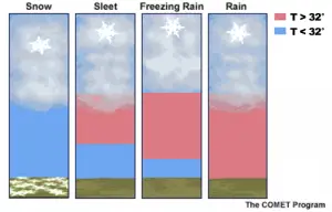
Winter Precipitation and Weather Terms
My Take Away
There will be a winter weather event starting Monday and lasting into Tuesday.
This continues portray as expected: a mix to ice event.
After a very cold weekend, the ground will be able to support any snow stickage and icing.
If there is any snow, it would only be for the first two hours. Over running events can produce a snow burst that overachieve, just like we saw in that December 16 event. I will focus on temperature profiling this weekend to see if that opportunity presents itself again.
Tuesday Morning should be icy enough limit travel for much of the region.
The icing could be widespread and last well into Tuesday. Total amounts wil vary, but the potential for 1/2 inch of ice is enough take seriously and plan for. It can but not promised to take down some trees and power lines.
Even between 0.10” to 0.25” ice can linger for a few hours after any thawing. So just watching the thermometer does not tell the full impact to lift travel.
Please share your thoughts, best weather pics/video, or just keep in touch via social media
Facebook: Justin Berk, Meteorologist
Twitter: @JustinWeather
Instagram: justinweather
Winter Outlook Series


14 Local Maryland Pages (and York PA)
We have made a page for Maryland Weather which gives you the current conditions for 14 present area locations.

FITF Shop Open
My ‘bonus’ daughter Jaiden and wife showing off our popular Maryland Hoodies. Unisex and women’s items all produced in Maryland.
Click here to see this and many other new items.


Also see:
Maryland Weather Page
I wanted to keep it simple. Just the basics for a quick view at any time.

Just In Power Kids:
A portion of proceeds go to our programs Providing FREE holistic care for kids in cancer treatment and up to 5 years post treatment and caregivers.
![]()
New Caps and Hats

