Tuesday January 5 2021
The weather around the North Pole is getting disrupted and will send arctic air our way. This is what was missing last year, as the record strong Polar Vortex locked the cold air in place. When it gets moved around, then we get in on the cold action. That is what appears to be on the way.
I am not into promising amounts of snow or how cold, but this is the type of pattern that would extend subfreezing air and get parts of the Chesapeake Bay to freeze. Also, the active jet stream will provide many frequent opportunities for storms with snow. Faith in the Flakes!
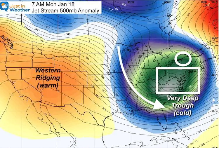
Jet Stream:
In less than two weeks, a series of strong surges of arctic air will push into the eastern US. This overall pattern supports below average temps and storms. I trust the pattern, not specific events/times.
This jet stream snap shot is for January 18. Not when it begins, but when the initial wave should fully be in place.
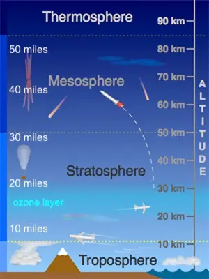
Atmospheric Layers
Before looking at the Sudden Atmospheric Warming at the North Pole, let’s go through a very brief understanding of our atmosphere.
Here is a cross section of the layers we study.
Troposphere: Our weather is in the bottom 7 miles.
Stratosphere: This is above most of our clouds and where the Ozone Layer is located.
Sudden Stratospheric Warming (SSW)
Occasionally the air around the North Pole has a rapid warm up in the stratosphere known as Sudden Stratospheric Warming or SSW.
We measure this at the 10 mb level, which is about 20 miles above the ground. That is where the warming is occurring. It’s not very warm, but relative to what is normal at that height can make a difference below.
When this occurs, it can send high altitude air to the surface. The result forces the Polar Vortex to wobble or even split into smaller ‘sister’ vortices.
What we see at the surface and in our part of the world is the arctic air sent southward as super cold air masses. This also infuses energy in the jet stream where it interacts with the warmer air in the Mid Latitudes.
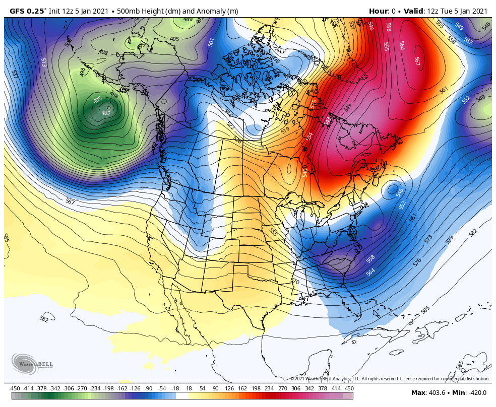
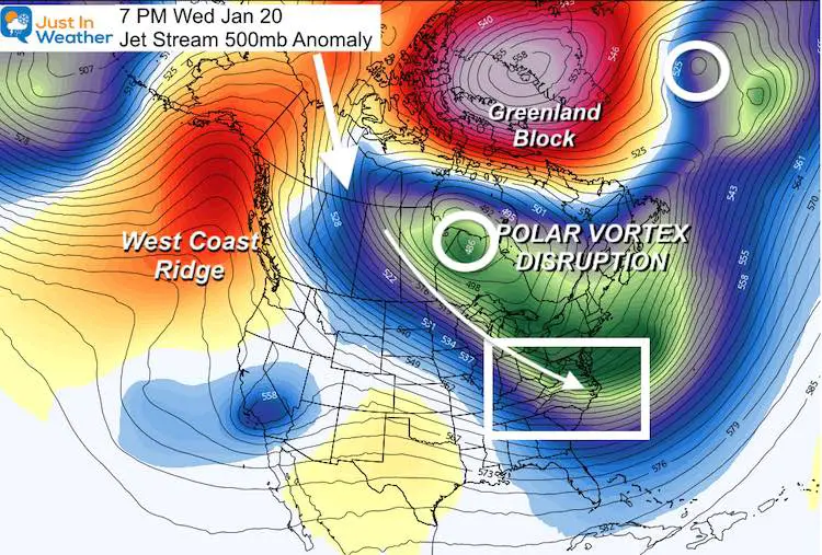
Jet Stream Gets Turbo Charged
Here is the GFS Forecast jet stream over the next 384 hours (ending Thursday Jan 21). That is a long time, but with large scale patterns like this there is more confidence than in surface features.
Even without a degree in meteorology, the deep trough of COLD AIR shows up as blue and green. The red and pink are NOT hot air, but the ridge and warming aloft.
Snap Shots
Big Time Cold Air is what is getting us weather geeks all excited. A pattern like this has not been seen in a long time.
This first image is not the first wave, but when it should fully be in place for us… Monday January 18. We will have some hits, and even some storms before then. But at this time, the translation should be a deep freeze for most day and night, with a little lag for the main cities and around the water.
But Chesapeake Bay freezing kind of cold is what is expected that week.
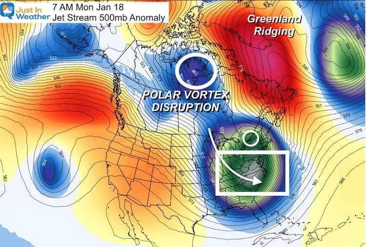
Jump forward only two more days and check this out!
The Polar Vortex make push south of Hudson Bay in Canada surging even more arctic air into the eastern US. This is all thanks to a very profound Greenland Blocking High. We discussed that in Sunday night’s report.
I also want point out the ‘cross polar’ flow. That is the arrow just under the banner. That is a long wave flow that allows air from Siberia to cross the Pole into NW Canada and continue to drive south. That is where sustained arctic outbreaks are made from.
What Other’s Are Saying
Let’s first hear from our friend Dr. Judah Cohen. Here’s how I retweeted him today:
When those who research the Polar Vortex go from cautious optimism to ‘major league’ for the event this month… we
PUMP UP OUR #FITF
🥶💙❄️⛄️ https://t.co/InkPWx4PWh— Justin Berk (@JustinWeather) January 5, 2021
Here’s M J Ventrice with a pretty cool 3-D perspective of the Polar Vortex predicted split on January 19.
Interesting structure regarding the Stratospheric Polar Vortex predicted split. We’re seeing sister vortices and one is much larger than the other. pic.twitter.com/f0plxpJebZ
— MJVentrice (@MJVentrice) January 5, 2021
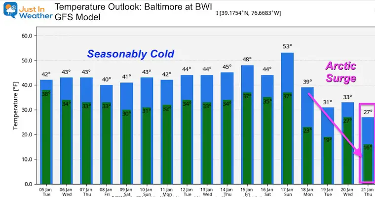
Temperature Outlook
PLEASE NOTE: The modeling has trouble handling such extreme events like this in long range plots.
The temperature drop farther out is balanced a lot by climatology. Short story is that we could end up colder than what is shown here… and this is just a projection for Baltimore at BWI Airport.
Tl;dr Too Long Didn’t Read
#FITF It is going to get VERY COLD very soon. We may have some chances at snow leading up to the event, but the truly arctic will be here within 2 weeks, and might last a while.
Local ponds, reservoirs, rivers, and northern parts of the Chesapeake Bay will have a chance to freeze a top layer of ice.
Real winter will return and inevitably there will be many opportunities for snow.
Faith in the Flakes!
Also Read:
Winter Outlook Series


14 Local Maryland Pages (and York PA)
We have made a page for Maryland Weather which gives you the current conditions for 14 present area locations.

FITF Shop Open
My ‘bonus’ daughter Jaiden and wife showing off our popular Maryland Hoodies. Unisex and women’s items all produced in Maryland.
Click here to see this and many other new items.


Also see:
Also See:
December Climate, Sun Data, Solstice, ISS Flyovers, Moon, Planets, and The Great Conjunction

Maryland Weather Page
I wanted to keep it simple. Just the basics for a quick view at any time.

Please share your thoughts, best weather pics/video, or just keep in touch via social media
Facebook: Justin Berk, Meteorologist
Twitter: @JustinWeather
Instagram: justinweather
Email Updates
Please make sure you sign up (above or click here to sign up for email alerts…. ) for my newsletter. This way you will get an email to make sure you are notified of each post.
Just In Power Kids:
A portion of proceeds go to our programs Providing FREE holistic care for kids in cancer treatment and up to 5 years post treatment and caregivers.
![]()
New Caps and Hats

