December 28 2020
I didn’t want to do this. I didn’t want to throw out yet another possibly wintry weather event days away. I didn’t want to bring it up because it falls on New Year’s Day, which under normal circumstances would be a late sleeping, slow travel kind of day anyway. I also didn’t want to touch the subject of any partying or travel plans, because of that COVID thing. But, this needs to be mentioned for a few reasons.
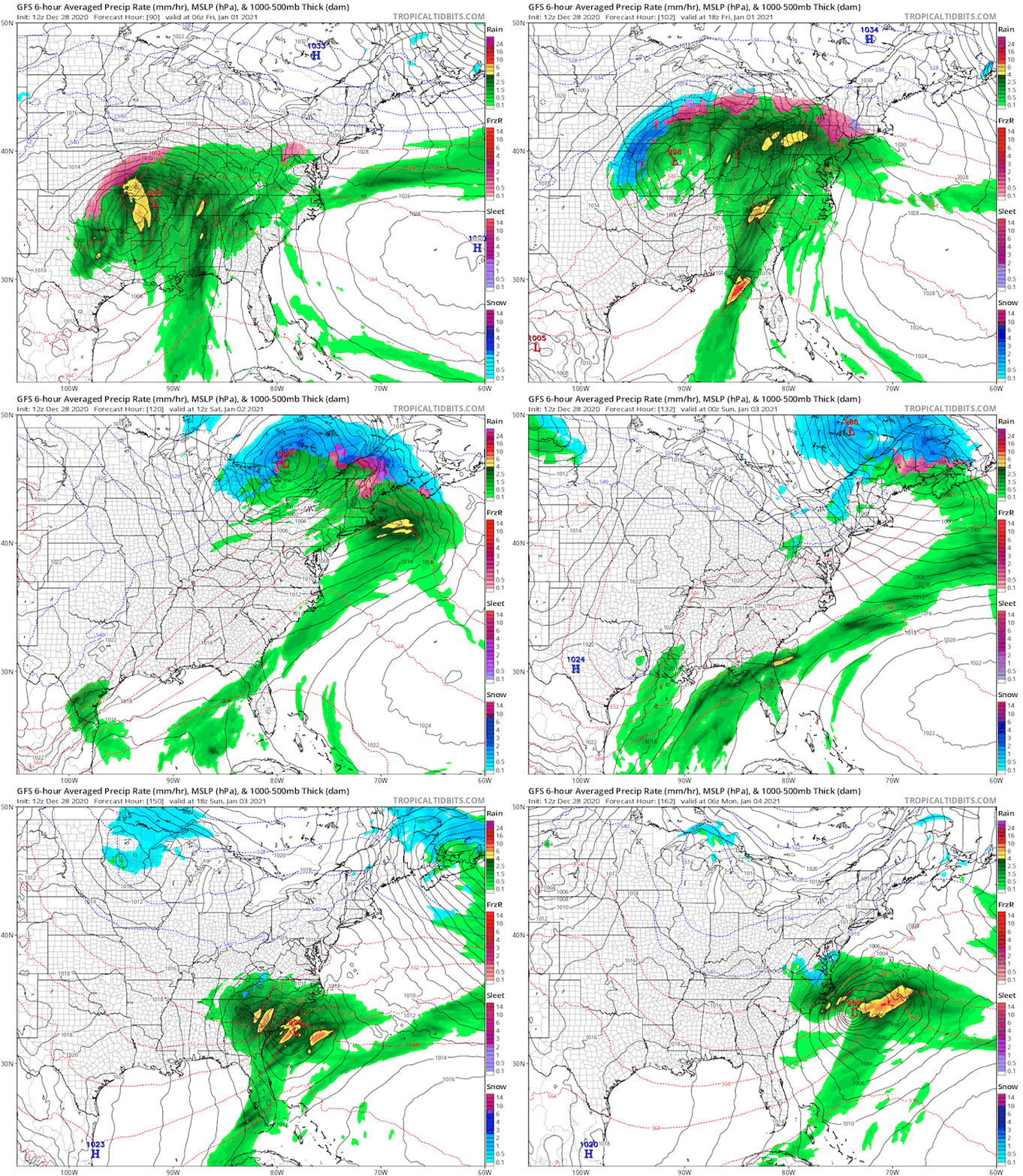
Here both the GFS and European ECWMF are showing freezing rain west of the Bay Friday morning.
New Year’s Day Ice?
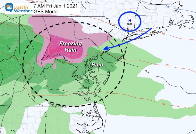
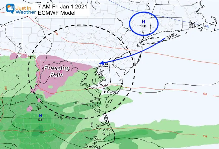
Last night I first mentioned the chance for inland ice on Friday morning, and there is more model agreement for it. I am showing this to:
- Track the plot and timing trend of any freezing rain.
- After all indications showed a mild start to January, the cold really is trying to fight back.
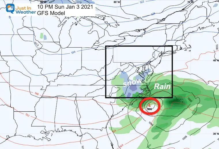
- There is another small system in the pipeline to end the weekend that has been trending north. If that trend continues, it could bring light snow into parts of our area Sunday night.
I continue to not trust mid range modeling, and I keep showing these forecasts to you to help identify the bias so we maybe can outsmart them.
Let’s back up to this evening’s set up:
A cold front is bringing in a new cold air mass. You will notice this with high temps only in the 30s to bear 40ºF for the next two days.
The storm is in the Four Corners region of the SW US.
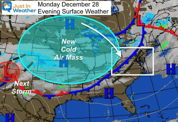
This same front will be lingering and trying to come back north on Thursday to let rain ride along it.
But the next cold air mass from Canada will be fighting the warm push of the storm coming out of the Gulf Coast.
Watch as the rain bumps into cold surface air on Friday morning. This will be on the edge of the influence of High Pressure and that cold air mass.
Storm Simulation —> slider
Storm Animation
Let’s watch the same GFS model in motion. This starts with the freezing rain shorty after midnight on New Year’s Day morning. It ends with the small coastal trying to get close Sunday night.
Sunday Night
I’ve been watching this little system for a few days. Each new model run brings it farther north. That north trend seems to be a recurring theme so far this season. So is the colder air winning when it can.
That’s why I simply wanted to mention this now. This looks minor, and at this time brining flakes to southern Maryland. Perhaps it could get another bump farther north.
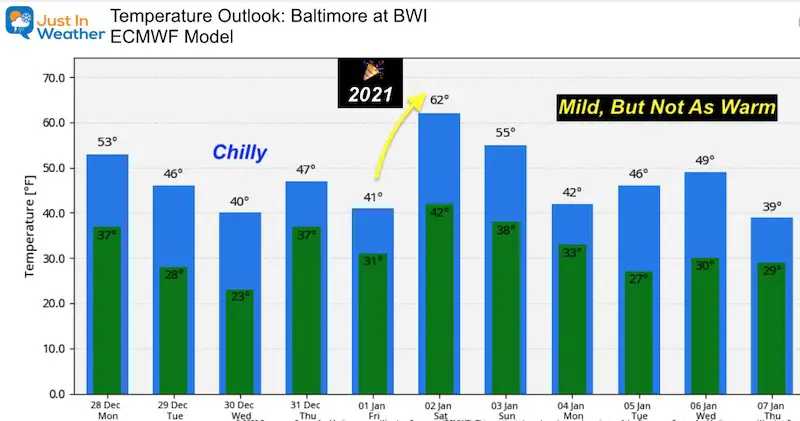
Temperature Outlook
The noticeable change here is ‘not as warm’.
This is for Baltimore at BWI, so the inland suburbs will be cooler. Especially the next two days.
Friday = New Year’s Day. Regardless of any early ice or not, the day will be perfect for staying inside thanks to a chilly rain.
Saturday is still holding a spot in the 60s, but next week is not looking as warm as it did last night.
I still do not trust mid range modeling. I show these maps and products to help point out any trends or spot errors ahead of time.
Tl;dr Tool long; didn’t read?
Here’s the short version.
- Tuesday and Wednesday will be cold!
- Thursday some showers.
- Friday = New Year’s Day. We may have ice inland around sunrise, then just a chilly rain.
- Next weekend = warmer!
14 Local Maryland Pages (and York PA)
We have made a page for Maryland Weather which gives you the current conditions for 14 present area locations.
FITF Shop Open
My ‘bonus’ daughter Jaiden and wife showing off our popular Maryland Hoodies. Unisex and women’s items all produced in Maryland.
Click here to see this and many other new items.
Also see:
Also See:
December Climate, Sun Data, Solstice, ISS Flyovers, Moon, Planets, and The Great Conjunction
Maryland Weather Page
I wanted to keep it simple. Just the basics for a quick view at any time.
Please share your thoughts, best weather pics/video, or just keep in touch via social media
Facebook: Justin Berk, Meteorologist
Twitter: @JustinWeather
Instagram: justinweather
Email Updates
Please make sure you sign up (above or click here to sign up for email alerts…. ) for my newsletter. This way you will get an email to make sure you are notified of each post.
Just In Power Kids:
A portion of proceeds go to our programs Providing FREE holistic care for kids in cancer treatment and up to 5 years post treatment and caregivers.

New Caps and Hats

