Sunday December 27 2020
What are we going to do with all of this cold air? Now that we got a true winter pattern in place, this and ‘when are we going to get real snow’ have been the top questions. The quick answer is that there will be opposing forces at play. Warmth will win in the short term, but the cold air is building may unleash at the right time. That’s what I want to discuss here.
Have you heard of Tl;dr? If not, I will explain at the bottom of this post.
For what it’s worth (from a Baltimore) perspective, the winter weather in place now has been bonus. Most, if not all early season outlooks had a call for a mild December.
BWI will end this month above average on temperature even with 4 or more days only reaching the 30s. But the 1.6″ of snow at the airport almost matches the pathetic showing all of last winter. A normal winter would bring a total of inches. They had that outside BWI in the city!
We (fellow snowhounds) are dong OK. Remember that mid month snow was the biggest in two years It dumped 3 to 6 inches of snow across much of the region with 6 to 10 inches across much of the norther suburbs.
Local ski areas have had their best start in a few years. So, this has been beneficial.
Now, we relax the pattern a bit, and give something back to our warm blooded friends. But we will get our winter back soon enough.
Storm Forecast (GFS) This Week
The storm track pulls back to our west. That keeps us on the warmer and rainy side, and keeps mild air around after it passes. This is what will bring us an above average pattern around the new year.
7 PM Mon Dec 28 to 7 PM Sat Jan 2
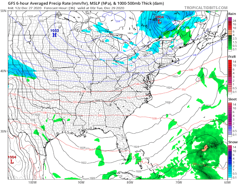
This looks like another rain maker with warm air. The cool down after the event will be delayed and not as cold as what we just had.
Long Range Winter Signals Conflicting
In prior article I have discussed the Arctic Oscillation AND North Atlantic Oscillation. Both of these often indicate if we will get cold air and a chance for winter storm in the eastern US when NEGATIVE.
They are BOTH expected to be NEGATIVE!
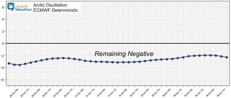
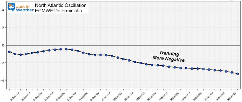
The problem is that the opposing force will dominate our weather pattern. There is a simple explanation for this.
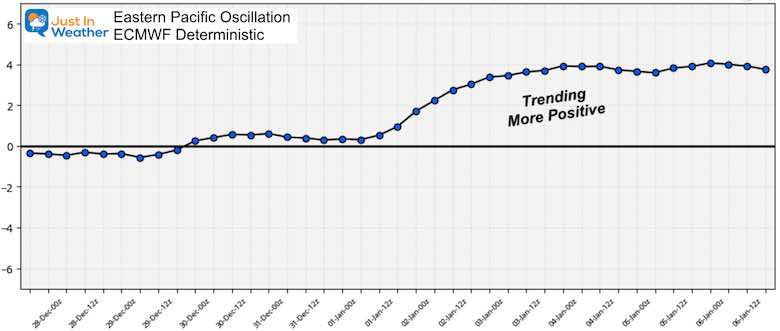
Here is the Eastern Pacific Oscillation (EPO) Forecast
This is will be positive, and trending stronger into the first week of the new year.
This takes us to January 6, 2021
What is this?
This graphic helps explain the pattern, but it might be hard to follow.
The short version: a Strong. Positive EPO increases the wind flow at jet stream level from west to east. That ‘zonal’ flow prevents cold air from pushing south. The cold air remains ‘blcoked’ or ‘bottled up’ in the arctic. But, I think that might be a good thing….
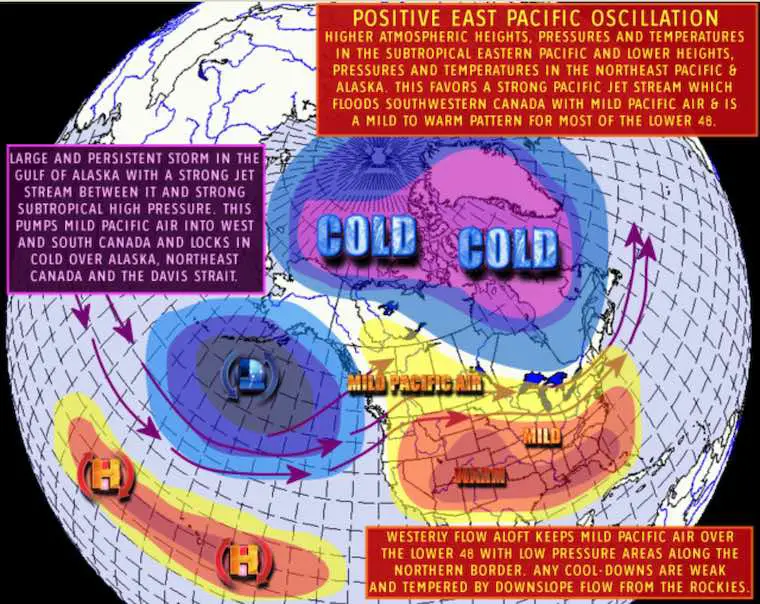
This explanation is from Dacula Weather
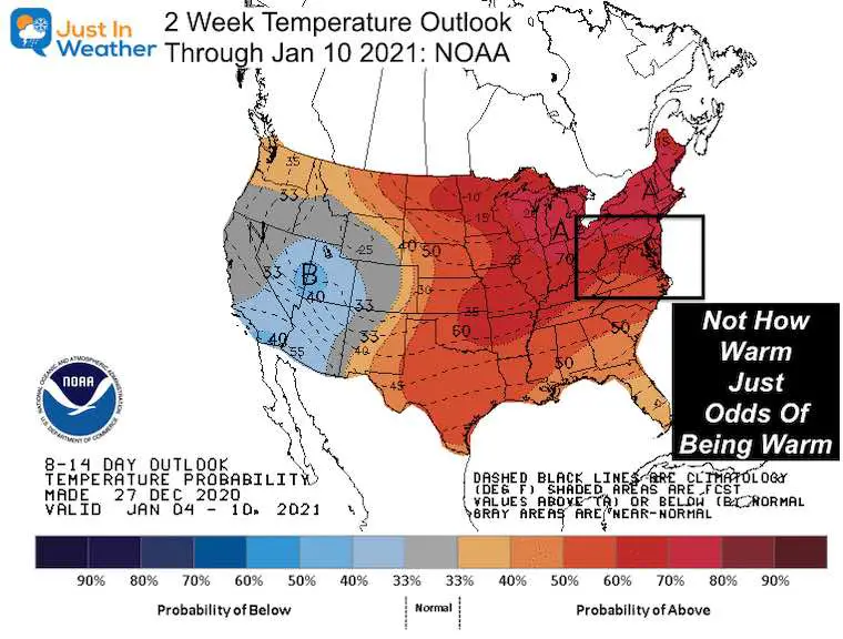
NOAA Temperature Outlook
This is the ‘average’ expectation for temperatures ending January 10, 2020.
This is NOT how warm it will be, just the odds of it being warmer than average.
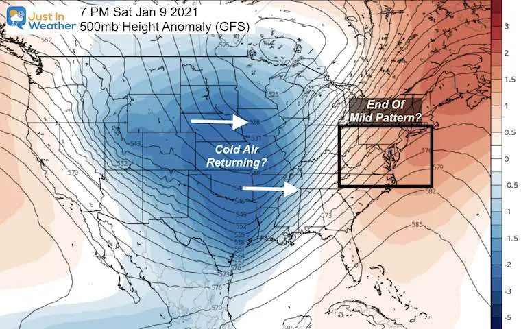
Breaking Down The Pattern
Fast forward to January 9, and the GFS shows the end of our warm pattern with a deep trough of cold air returning.
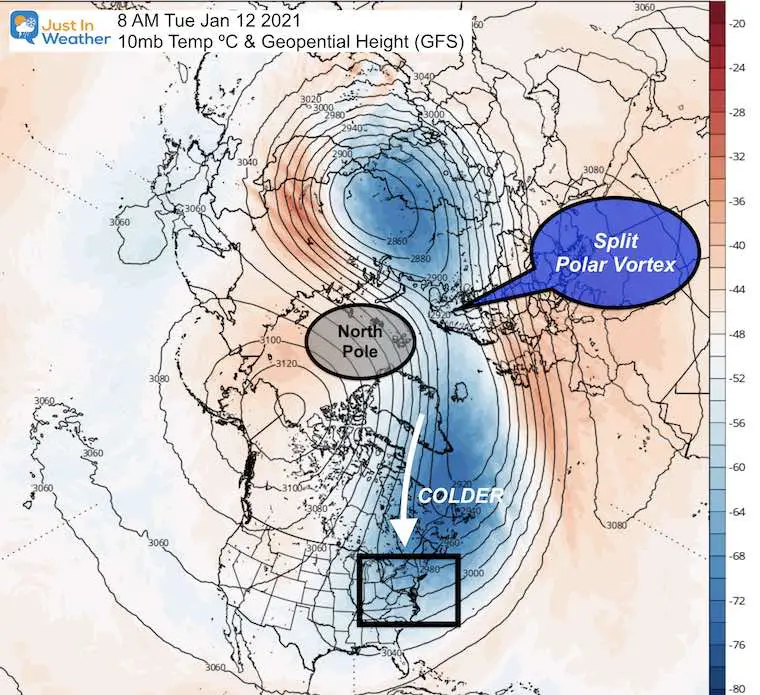
Polar Vortex Split
Long Range Modeling supports a split in the Polar Vortex. That’s a good thing if you want cold air!
Fast Forward to January 12: This will disrupt the cold air that has been bottled up for two weeks. January is the coldest month in the northern hemisphere, so if we can get this to break and push south at that time, it will have maximum effort with it to help break down the zonal flow from the EPO.
I am not alone. Here is a recent tweet from the great Dr. Judah Cohen- Polar Climate Expert. He sees this happening as well. Plus a stronger signal for the end of January.
The GFS is back on the #polarvortex (PV) split train. I don’t know if a major disruption of the PV will occur the first week of January but our speculative PV model suggests that if it does not occur in early January there is still a very good chance in late January. pic.twitter.com/J7H2zERhYO
— Judah Cohen (@judah47) December 24, 2020
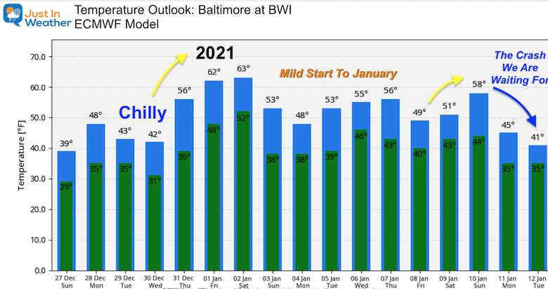
Temperature Forecast
Please take these numbers with a grain of salt. This is simply a guide for trends near, above, or below average.
What I see here:
More 60s? Yes! That could be around the New Year and early January. No worries. If you read my winter outlook and saw my suggest of an analog to 2000, we started that month off very warm as well. Then we had out three storms three weeks later.
Here. I see a mild week, not as warm as the January 200 event.
The crash we snowhounds are waiting for could be as soon as January 10 or 11, when the Polar Vortex splits. This would be just the beginning.
Tl;dr
If you never saw this before, I am doing it for my wife and anyone else who just wants the summary. It means
Too long; didn’t read.
I get it, but you might want to go back and see what some of the graphics mean. If you like this, let me know and I’ll make this more of a routine.
*The cold air will relax for a few weeks. Temps will warm up around New Year’s Eve/Day. Then we will have a mild start to Janaury. But much cold air is building, and I expect winter to return by the middle of January. Then the real fun begins.
The real short version:
Warming for a few weeks. Then #FITF by Mid January. We will get more winter and snow.
Winter Outlook Series


14 Local Maryland Pages (and York PA)
We have made a page for Maryland Weather which gives you the current conditions for 14 present area locations.

FITF Shop Open
My ‘bonus’ daughter Jaiden and wife showing off our popular Maryland Hoodies. Unisex and women’s items all produced in Maryland.
Click here to see this and many other new items.


Also see:
Also See:
December Climate, Sun Data, Solstice, ISS Flyovers, Moon, Planets, and The Great Conjunction

Maryland Weather Page
I wanted to keep it simple. Just the basics for a quick view at any time.

Please share your thoughts, best weather pics/video, or just keep in touch via social media
Facebook: Justin Berk, Meteorologist
Twitter: @JustinWeather
Instagram: justinweather
Email Updates
Please make sure you sign up (above or click here to sign up for email alerts…. ) for my newsletter. This way you will get an email to make sure you are notified of each post.
Just In Power Kids:
A portion of proceeds go to our programs Providing FREE holistic care for kids in cancer treatment and up to 5 years post treatment and caregivers.
![]()
New Caps and Hats

