December 17 2020
Recapping the first storm of the season, and biggest event in two years, Many places got more snow than all of last winter! I have lots I want to share with you and document here for reference.
As always, I want you to grade my forecast. This time added a poll below to tally as many as possible in one place.
In this report you will see:
- Regional Snow Map And Satellite
- Time Lapse Snowfall Video – My first complete storm!
- Grade My Forecast Poll
- Local Snow Reports and Compare with my Final Call For Snowfall
I started discussing this storm last Thursday, and it got a lot of attention. I believe it deserved it for the region. I will highlight what I think worked out and what went wrong.
I know some will say this was a bust. That always happens. Some will say it was perfect. But the reality in between is where I am interested. I do this service for you and value your trust.
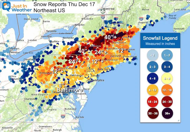
Record Snow
Binghamton NY was a big winner with 41” inches of snow. I worked there at WBNG TV before moving to Baltimore in 1997. They know snow, but that was a record!
They also recorded:
6” in one hour
20.5” in a 6 hour span.
*There were other 40 inch reports into southern Vermont.
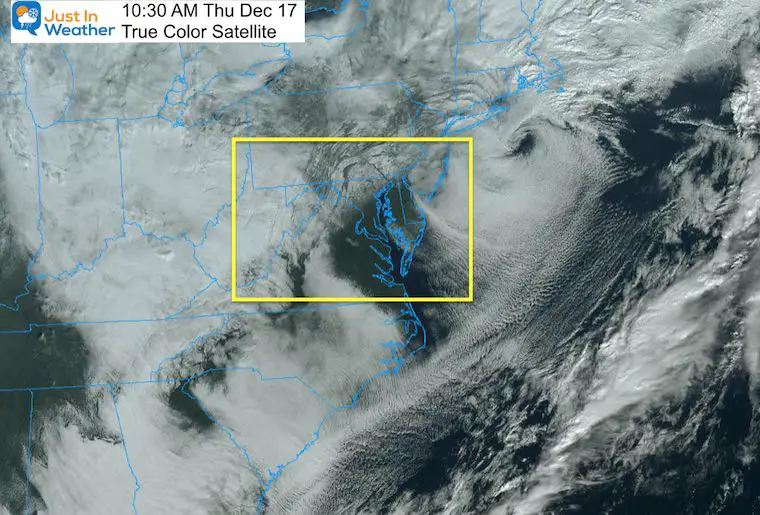
Satellite This Morning
This storm was so intense, we can see what appears to be an eye on satellite south of New England. This is somewhat common with the strongest winter storm. I have a closer look at our region below.
Time Lapse Video
I want to start with my very first complete storm Time Lapse Video
- We had two rounds of snow with sleet in between that compressed totals a little.
At one point nearly 3 inches fell in one hour.
The second surge was between midnight and 2 PM
Final total zoomed in at the end: Between 10 to 11 inches (around the MD/PA line)
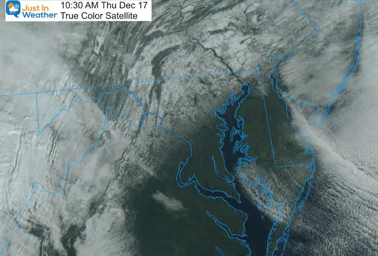
Snow Line From Space
This close up of the visible satellite this morning showed the snow line lined up very close to I-95.
Why does this happen? Because I-95 was built on the Fall Line. North and. West the elevation increases, it is farther away from the warmer Chesapeake Bay, and colder.
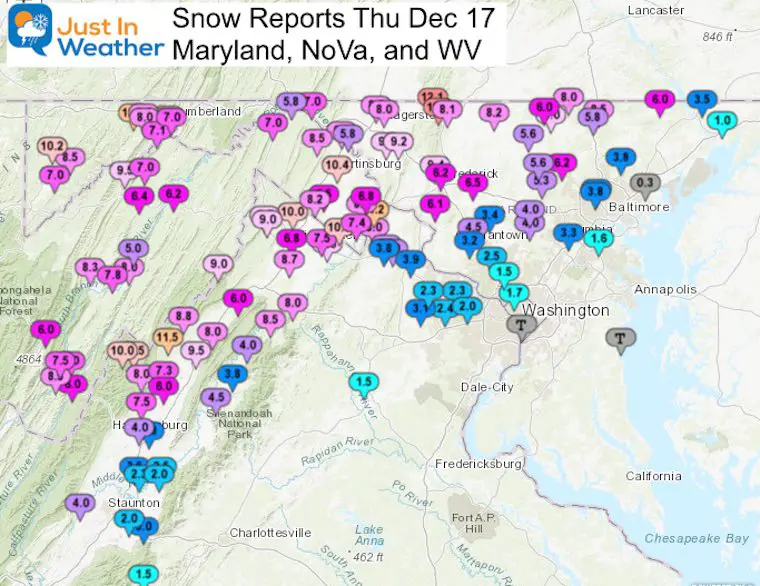
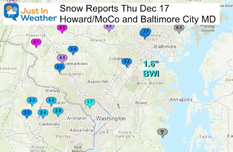
Snow Reports
Regional Map
See County maps and spotter reports below.
My Final Call For Snowfall.
Use this map to compare to results below.
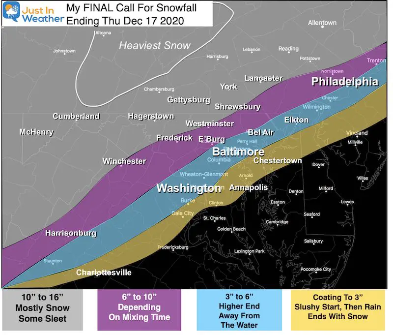
What Went Right:
- Sleet, icing, and Rain were on target.
- Most of my zones worked out: 6″ to 10″; 3″ to 6″, and even the Coasting to 3″
- Thursday morning temps in the 20s starting the day icy for many!
- My First Call and Final Call were almost the same. I did shave off the south end.
- I played it conservative: My call was LOWER than NWS, Most Models, and many local TV offices.
- Snow zones: Mostly Right, but we can compare to my forecast below.
What went wrong:
- The arrival was almost 2 hours earlier than I expected.
- The front end overachieved for many, but the back end was lower.
- A little under 10” in many of my 10″+ zones
My Personal Grade: B+
YOU GRADE MY FORECAST
Please scroll down to compare the spotter maps to my final call for snowfall below.
How would you grade my forecast and sharing of information?
*Not the web server, that was out of my control and my IT team worked tirelessly to fix it.
How would you grade my forecast: Dec 16th Snow and Ice Storm?
- A- (28%, 315 Votes)
- A (Thanks) (27%, 304 Votes)
- B+ (24%, 269 Votes)
- B (12%, 139 Votes)
- B- (4%, 45 Votes)
- C (3%, 37 Votes)
- D (1%, 12 Votes)
- F (Come on, really?) (1%, 6 Votes)
Total Voters: 1,127
Offical Snow Total:
Baltimore at BWI= 1.6” Snow, but total liquid was 1.42”
Baltimore City = *Will not go into the climate record.
- Mount Washington = 4.1″
- Pimlico = 3.8″
More Local Snow Maps
Please note, these are NWS maps and the color can make it difficult to see. I highlighted where I could.
Harford, and Cecil
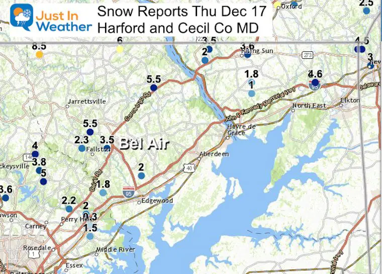
…Cecil County…
Rock Springs 1 ESE 3.5 500 PM 12/16 Trained Spotter
Woodlawn 2 E 1.0 500 PM 12/16 Trained Spotter
…Harford County…
Norrisville 1 WSW 8.5 627 AM 12/17 CoCoRaHS
Whiteford 6.0 1137 PM 12/16 Trained Spotter
Kingsville 3 NNE 3.1 700 AM 12/17 CoCoRaHS
Frederick, Carroll, Howard, and Baltimore
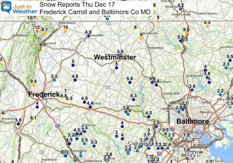
…Frederick County…
Sabillasville 1 NNW 12.1 1159 PM 12/16 CoCoRaHS
Sabillasville 2 SSE 12.0 800 AM 12/17 Trained Spotter
Emmitsburg 2 SE 10.0 650 AM 12/17 Co-Op
Observer
Thurmont 3 N 8.1 700 AM 12/17 NWS Employee
New Market 3 NNW 7.0 345 AM 12/17 CoCoRaHS
Thurmont 1 SSE 6.8 700 AM 12/17 CoCoRaHS
Bloomfield 2 WSW 9.4 700 AM 12/17 NWS Employee
New Market 2 NW 6.8 800 AM 12/17 CoCoRaHS
New Market N 6.5 700 AM 12/17 Trained Spotter
Frederick 1 W 6.2 800 AM 12/17 Trained Spotter
Adamstown 1 ESE 6.1 646 AM 12/17 Trained Spotter
Union Bridge 7 SSW 4.8 700 AM 12/17 CoCoRaHS
Carroll County
Manchester 1 SSW 9.0 820 AM 12/17 Trained Spotter
Taneytown NE 8.2 900 AM 12/17 Trained Spotter
Millers 4 NE 8.0 411 AM 12/17 Co-Op Observer
Manchester 2 NW 6.0 447 PM 12/16 Trained
Millers 4 NE 6.0 600 PM 12/16 Co-Op Spotter
Gamber 1 WNW 5.6 830 AM 12/17 CoCoRaHS
Westminster SE 5.6 700 AM 12/17 Trained Spotter
Eldersburg 1 SE 5.3 700 AM 12/17 Trained Spotter
Observer
Eldersburg 1 E 5.3 700 AM 12/17 CoCoRaHS
Westminster 3 SSW 5.0 700 AM 12/17 CoCoRaHS
Mount Airy SE 4.4 700 AM 12/17 CoCoRaHS
Baltimore
Bentley Springs 1 E 8.5 615 AM 12/17 Trained Spotter
Glyndon 1 WSW 6.2 1100 AM 12/17 Trained Spotter
Parkton 1 W 5.8 440 PM 12/16 Trained Spotter
Reisterstown 1 NW 5.4 700 PM 12/16 CoCoRaHS
Long Green 1 SW 5.0 700 AM 12/17 CoCoRaHS
Towson 1 SW 5.0 830 AM 12/17 CoCoRaHS
Long Green 2 NW 3.8 800 AM 12/17 Trained
Timonium NE 3.6 700 AM 12/17 CoCoRaHS
Kingsville 1 E 1.8 700 AM 12/17 CoCoRaHS
White Marsh 2 ESE 1.5 700 AM 12/17 CoCoRaHS Spotter
White Marsh 2 E 0.3 1116 PM 12/16 Trained Spotter
…Baltimore City…
Pimlico SE 3.8 600 AM 12/17 Trained Spotter
Pikesville 2 SE 3.7 1015 PM 12/16 CoCoRaHS
Howard Baltimore
Dayton 4.0 452 PM 12/16 Broadcast Media
Glenelg 2 N 4.0 550 PM 12/16 Trained Spotter
Columbia 2 N 3.8 700 AM 12/17 CoCoRaHS
Sykesville 2 SSE 3.4 700 AM 12/17 CoCoRaHS
Elkridge 2 W 3.3 730 AM 12/17 Trained Spotter
Elkridge 2 W 3.2 530 AM 12/17 CoCoRaHS
Marriottsville 3 S 2.5 700 AM 12/17 CoCoRaHS
Laurel 1 NNE 2.2 700 AM 12/17 CoCoRaHS
North Laurel 2 ESE 1.7 700 AM 12/17 CoCoRaHS
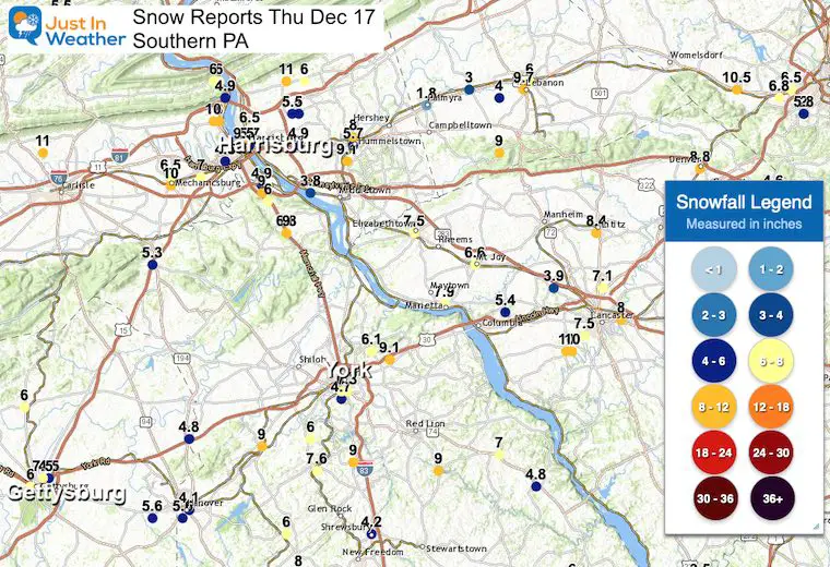
Southern PA
Harrisburg set a daily record for snow and had more than all of last year.
Most of this region was in my 10″+ zone, but ended up mostly 6 to 10 inches.
Also see:
Winter Outlook Series


FITF Shop Open
My ‘bonus’ daughter Jaiden and wife showing off our popular Maryland Hoodies. Unisex and womens items all produced in Maryland.
Click here to see this and many other new items.


Also See:
December Climate, Sun Data, Solstice, ISS Flyovers, Moon, Planets, and The Great Conjunction

14 Local Maryland Pages (and York PA)
We have made a page for Maryland Weather which gives you the current conditions for 14 present area locations.

Maryland Weather Page
I wanted to keep it simple. Just the basics for a quick view at any time.

Please share your thoughts, best weather pics/video, or just keep in touch via social media
-
Facebook: Justin Berk, Meteorologist
-
Twitter: @JustinWeather
-
Instagram: justinweather
Email Updates
Please make sure you sign up (above or click here to sign up for email alerts…. ) for my newsletter. This way you will get an email to make sure you are notified of each post.
Just In Power Kids:
A portion of proceeds go to our programs Providing FREE holistic care for kids in cancer treatment and up to 5 years post treatment and caregivers.
![]()
New Caps and Hats

