1 PM Wednesday December 16 2020
The snow arrived early. For many it is already HEAVY!!!
That was the headline this morning that I was able to update on social media, (but not here on the website). I have more in depth look at this set up as we are in “Nowcasting Mode”. This is when we can compare the set up to how the models are performing or adjust ahead.
The roads are bad!
I had mentioned in my reports that it would get heavy in a hurry. It has! Snow in some parts of central Maryland has been falling at the rate over 1 inch per hour. A quick few inches on the front end…
At 1 PM, I heard (unofficially) that Howard County Police was working over 40 active accidents!
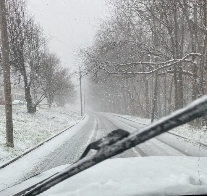
From an official in Howard County (remaining nameless). This was to show how quickly the roads got covered.
I Stand By My Forecast!
I believe this early hit, and the end hit tonight will verify for most areas. I will show that map again below.
The only concern I have now will be more icing this evening and tonight in between. We’ll get to that.
Quick Note About Change Over:
If you see BIG flakes, that is often a sign of warmer air at cloud level. They partially melt and then stick together on the way down.
Your thermometer may hold, but the clouds will warm. Then sleet and freezing rain may be the concern.
Faster Arrival
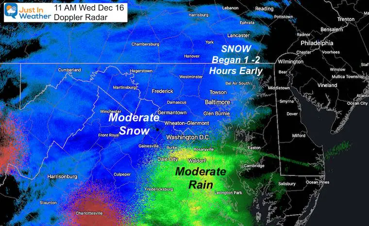
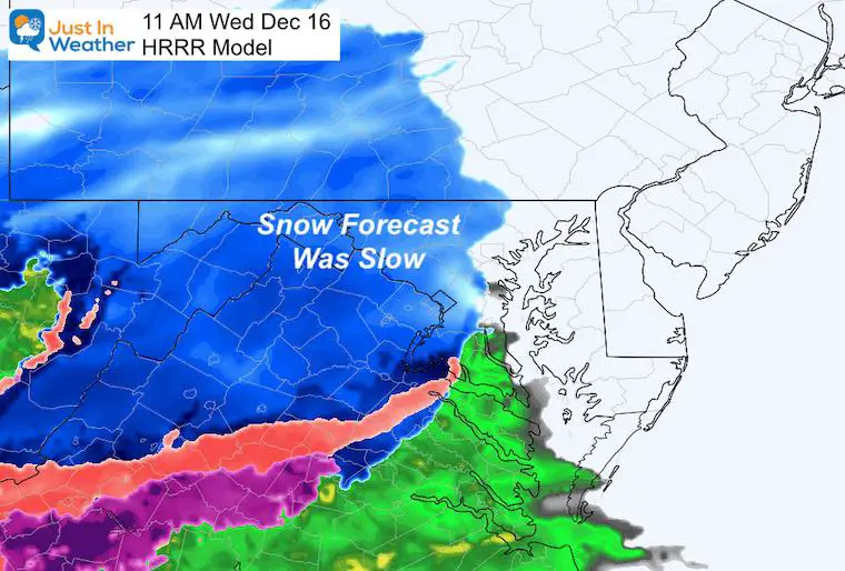
At 11 AM, Doppler Radar showed the snow, and numerous reports confirmed this snow falling was reaching the ground. This meant we did not get the ‘virga’, and the system was ahead of schedule.
Compare the Doppler To the HRRR (Short Range Model)
DOPPLER 11 AM
HRRR 11 AM
SNOW-DAY SALE ON ALL FITF Apparel:
10% OFF Will be Applied at Checkout
Analysis at Noon
(sorry it may be a little old. It took 2 hours to work these maps, write up, and publish)
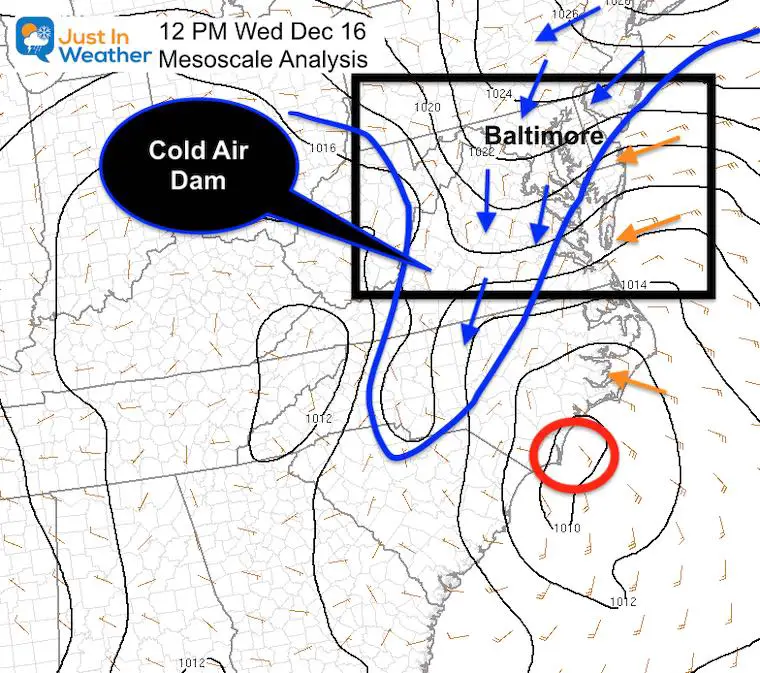
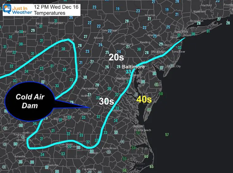
Have you heard of a cold air dam? It is cold dense air that spreads down the eastern US and sandwiched between warm air along the coast and on the other side of the mountains. That is common with winter storms and can do two things:
- Hold The Cold longer
- Disrupt the forecast with more ice in transition zones
Here we see that reflected on the Surface Analysis AND Temperatures
Mesoscale Analysis at Noon
This may be just a little SouthEast of forecasts. That may play a role in how far the warm air can push inland.
I’ve highlighted the Surface Low AND the surface wind direction.
Two things I have pointed out in almost all reports:
- Respect the Warmth from the water
- Wind Direction is Key!
Temperatures at Noon
This reflects the Cold Air Dam. The low dense air can be hard to budge and many models ofter push it out too soon.
Meanwhile the freezing line and warmer is right around I-95.
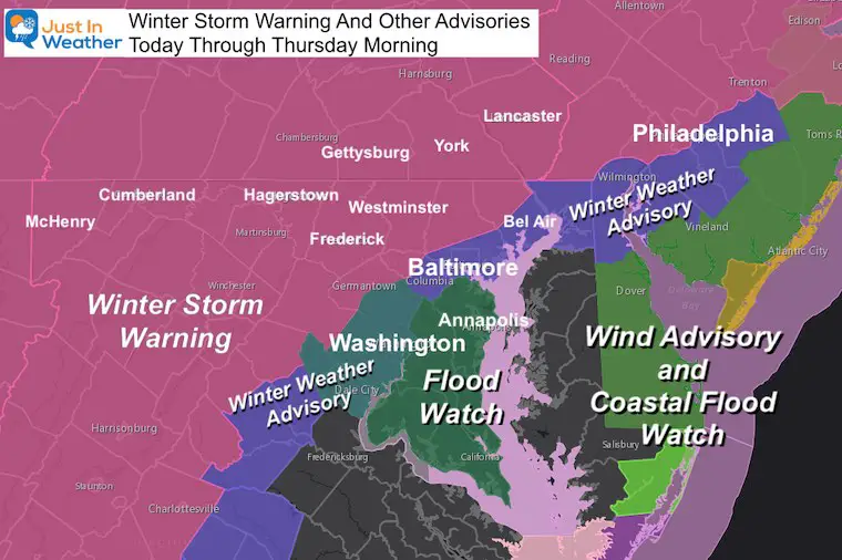
Reminder:
Warnings and Advisories
Evening Forecast
I DO NOT TRUST MANY MODELS AT THIS POINT
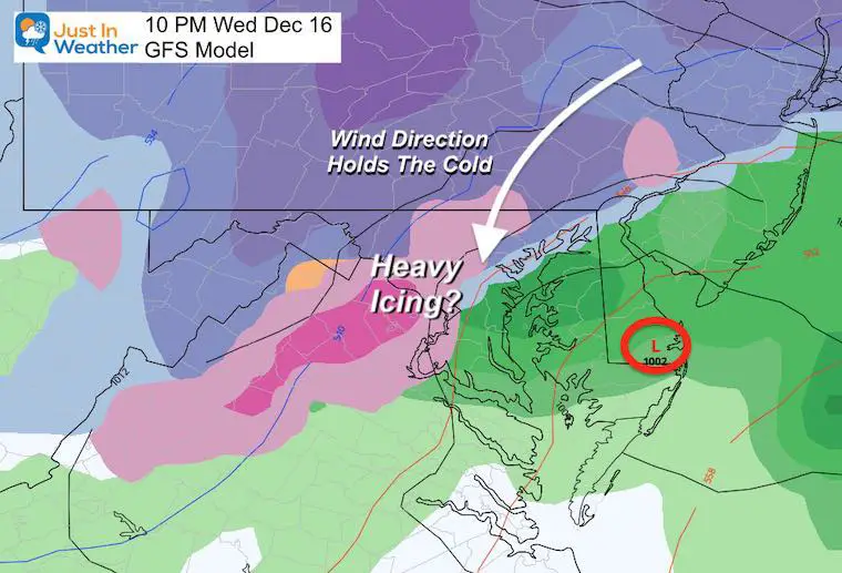
The Cold Air dam can be hard to move, so where it is cold it may hold longer. This can lead to sustained snow and ice, even on the edge where it is forecast to turn to rain.
The Wind Direction is KEY!
That will determine how much warmer air can mix it. It will warm the clouds, but at the surface just west and north of I-95 there may be extended icing. Farther inland it can be snow longer.
Where will this be? That can vary from a few miles to 20 miles. Sadly that is the most densely populated in Maryland.
GFS Model
Wind Forecast Map
This shows a more northerly component at 10 PM. That will battle any warming just inland from I-95!
But, warm air will fight farther inland at cloud level. That is why we can expect icing.
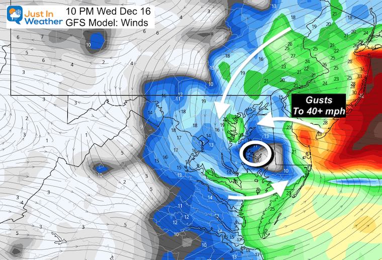
Why did I jump to this time?
Because this should be the peak of heavy mix or rain, and just before the cold comma head swings back through.
But, if the location is wrong and this verifies east, it will allow the cold air to hold in many more urban areas.
GFS Forecast
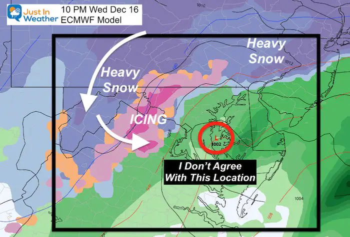
European Model Forecast
I still am not 100% confident this is addressing the cold air dam correctly.
10 PM
This Low is WAY WEST of earlier assessments. I have trouble accepting this.
But look at the tight ice and snow just west of the cities.
If this verifies just a little east, it should keep the ice and snow for immediate suburbs longer.
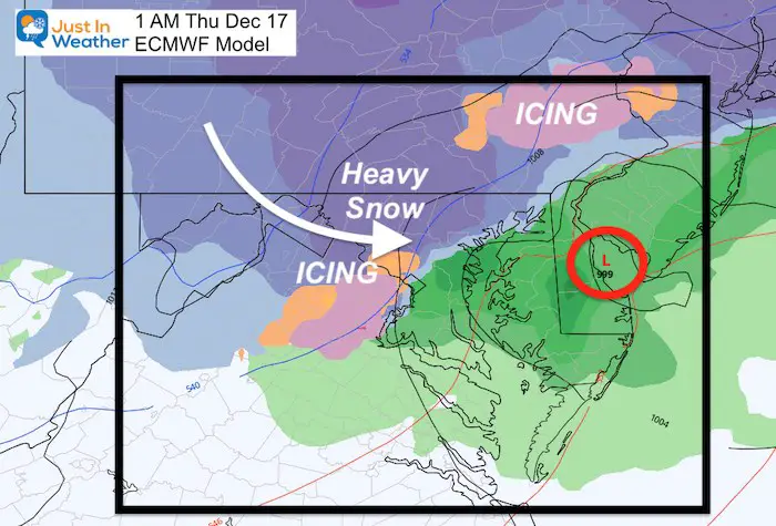
1 AM
Again. I am not sold on this location of the Low. But I am all in for the ‘comma head’ and heqvy snow swinging back through. This may have rates of 1”-2”/hour. That is the ‘Thump’ of snow to end this thing.
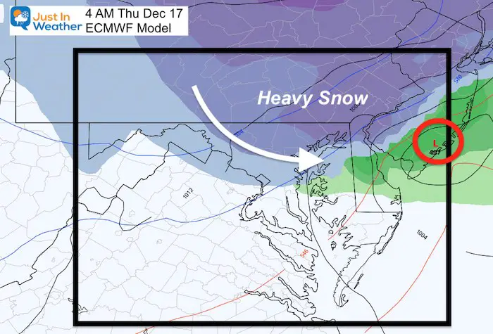
4 AM
Moderate to heavy snow from Baltimore and north. Again, this may bring the bulk of accumulation.
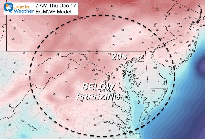
Thursday Morning Conditions
What is on the ground and untreated will be icy! Widespread below freezing temps
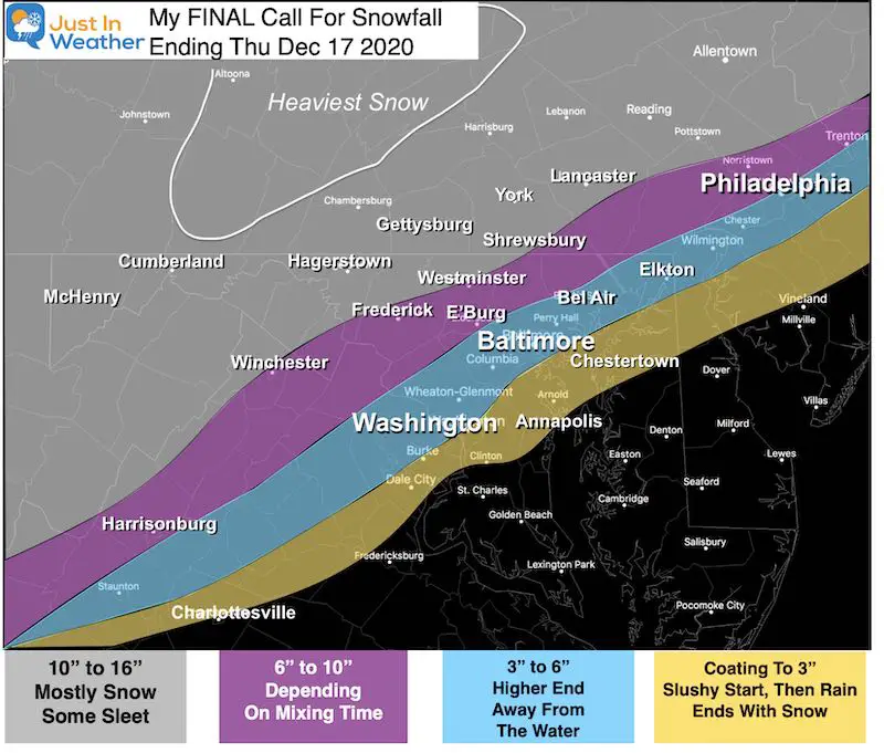
My Final Call For Snowfall From Yesterday!
I did not panic and change this. If anything the mixing might aim for the low end of the zone. But I will not hide from what I told you and you can grade me when this is done.
Also see:
FITF Shop Open
My ‘bonus’ daughter Jaiden and wife showing off our popular Maryland Hoodies. Unisex and womens items all produced in Maryland.
Click here to see this and many other new items.
Also See:
December Climate, Sun Data, Solstice, ISS Flyovers, Moon, Planets, and The Great Conjunction
14 Local Maryland Pages (and York PA)
We have made a page for Maryland Weather which gives you the current conditions for 14 present area locations.
Maryland Weather Page
I wanted to keep it simple. Just the basics for a quick view at any time.
Please share your thoughts, best weather pics/video, or just keep in touch via social media
-
Facebook: Justin Berk, Meteorologist
-
Twitter: @JustinWeather
-
Instagram: justinweather
Email Updates
Please make sure you sign up (above or click here to sign up for email alerts…. ) for my newsletter. This way you will get an email to make sure you are notified of each post.
Just In Power Kids:
A portion of proceeds go to our programs Providing FREE holistic care for kids in cancer treatment and up to 5 years post treatment and caregivers.

New Caps and Hats

