The burst of snow overachieved, but it put most areas in the expect snow zone already. If not there may another chance overnight with the back edge comma head of the storm.
Quick Note on what you will see in this post:
- My video of the ridiculous snow.
- Surface Analysis and Doppler.
- Return to ice for metro areas will be around midnight.
- Additional Snowfall MapReturn to snow for the region -Midnight to 5 AM.
- Freezing Morning: Temperatures in much of the region will drop into the 20s. What is wet may be iced up at daybreak.
Expect an icy morning!
We still have this rain and ice mix for much of the region, and I will do the analysis below. While there will be a burst of snow overnight, regardless of how much more you get, we all should drop into the 20s west of the Bay.
In a normal world, that would mean school delays and closings.I don’t need to explain much about that. But for anyone who does commute, I would consider another plan.
My Ridiculous Snow Video
I wanted to show you what we experienced in the local Tundra Zone. I was outside playing football with my kids and a neighbor, and had to stop to record this GIANT Flakes! We received 3 inches of snow that hour, and turned to sleet 10 minutes later
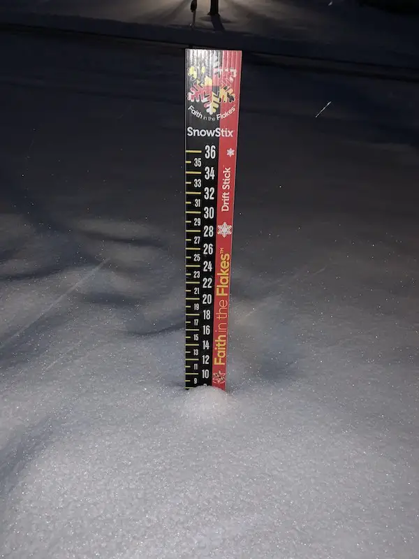
Round 1 Snow Total
We got 8 inches when the sleet took over.
Please note how much you received. The sleet and rain will compact it down. So if or when you add to it, the final total will not reflect the full amount for the storm.
SNOW-DAY SALE ON ALL FITF Apparel:
10% OFF Will be Applied at Checkout
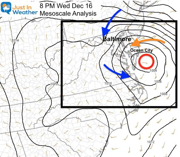
Evening Analysis: More on the way!
Low Pressure is plotted EAST of where the models suggested. That is allowing that cold air dam to hold for more interior areas.
That Low Pressure is now really beginning to intensify as the upper level energy is catching up to it.
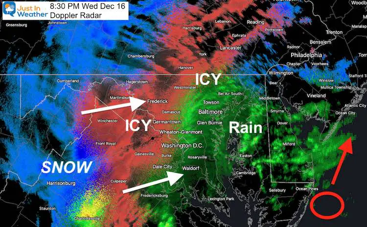
Will there be more?
Yes! We can see that developing on radar this evening.
The ice and snow zone to the west has increased in activity as the Low Pressure and upper level energy approach each other.
This is what will pivot through Our region tonight when the Surface Low moves up the coast.
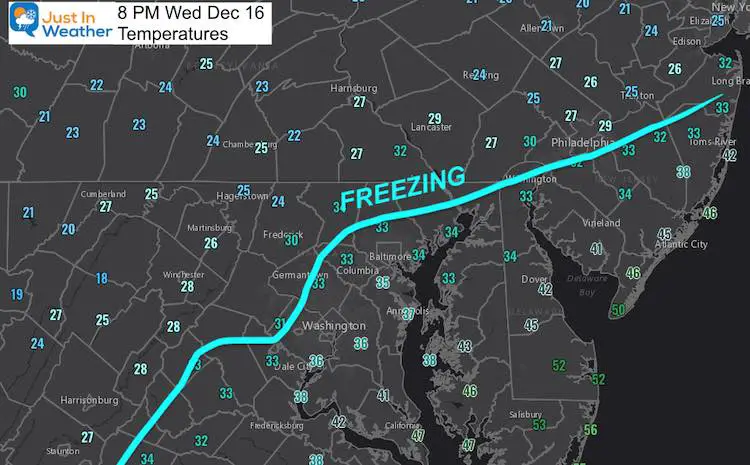
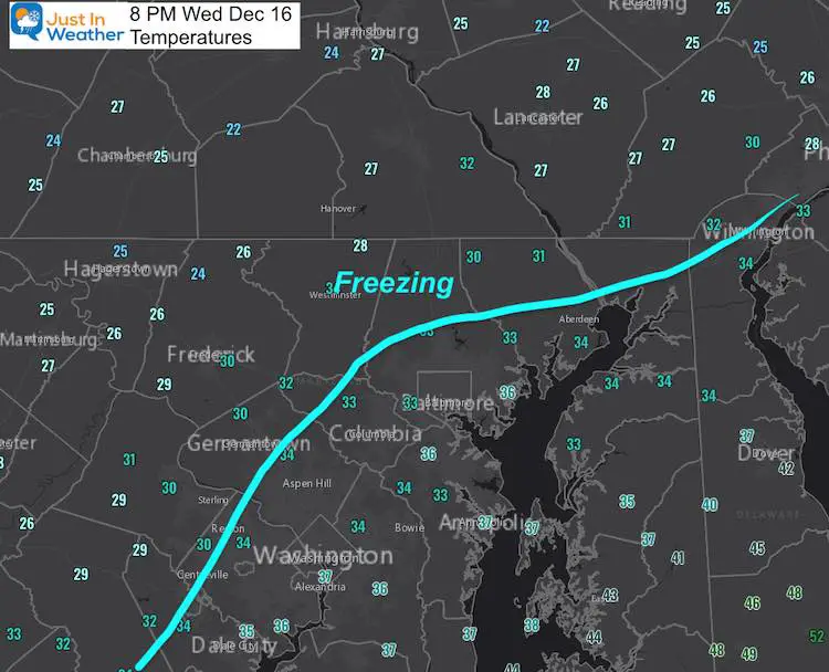
Temperatures:
That Freezing Line Is Holding Strong
This also means a lot of ice in these areas, with more snow on the way.
Short Range Model Forecasts
I still do not fully trust the models at this point, but I wanted to show you what they are displaying.
Keep in mind the snow arrived 2 hours early this morning. So we might apply the faster speed here as well.
Midnight
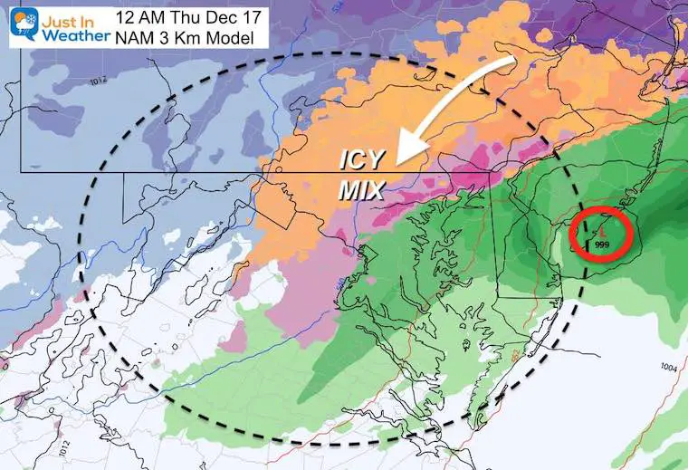
NAM 3 Km
This has the Low Pressure near Atlantic City.
The icy mix still for most of the interior just west and north of I-95.
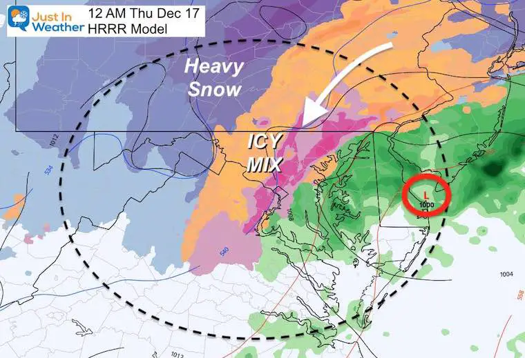
HRRR Model
This is a little colder, and brings the icy mix back down to metro Washington. Watch that Heavy Snow zone starting to move back east.
European ECMWF Model —-> slider
Let’s back up to 10 PM and go to daybreak.
I’ve highlighted the wind direction as that will play a role in the progression of cold air.


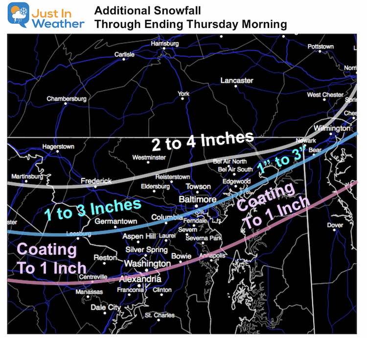
How much new snow?
This is my best call for more snow.
It will end before day break.
But potential for higher burst of snow if this arrives sooner.
Temperatures will drop below freezing and may will have lots of ice when they wake up.
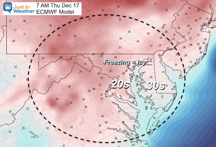
Temperatures
Freezing at Daybreak!
Widespread 20s expected at daybreak west of the Bay.
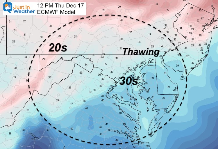
Thawing By Noon
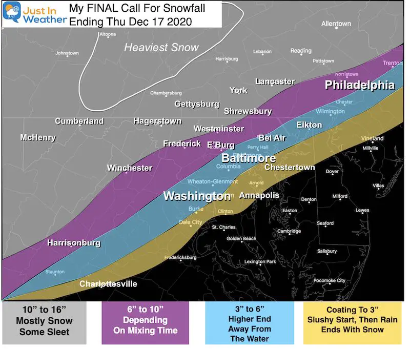
Another Look At My Final Call For Snowfall
- Many areas already verified, or will be very close. The overnight push should do it,
- What you measure in the morning may not reflect the complete snow after ice and rain compacting.
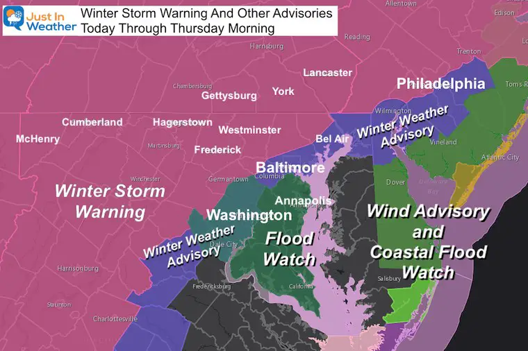
Recapping The Warnings And Advisories
Also see:

Winter Outlook Series


FITF Shop Open
My ‘bonus’ daughter Jaiden and wife showing off our popular Maryland Hoodies. Unisex and womens items all produced in Maryland.
Click here to see this and many other new items.


Also See:
December Climate, Sun Data, Solstice, ISS Flyovers, Moon, Planets, and The Great Conjunction

14 Local Maryland Pages (and York PA)
We have made a page for Maryland Weather which gives you the current conditions for 14 present area locations.

Maryland Weather Page
I wanted to keep it simple. Just the basics for a quick view at any time.

Please share your thoughts, best weather pics/video, or just keep in touch via social media
-
Facebook: Justin Berk, Meteorologist
-
Twitter: @JustinWeather
-
Instagram: justinweather
Email Updates
Please make sure you sign up (above or click here to sign up for email alerts…. ) for my newsletter. This way you will get an email to make sure you are notified of each post.
Just In Power Kids:
A portion of proceeds go to our programs Providing FREE holistic care for kids in cancer treatment and up to 5 years post treatment and caregivers.
![]()
New Caps and Hats

