Thursday December 10 2020
For the past couple of days I have included a small glimpse at a possible winter storm next week. I did this to shed some light that the computer modeling in long range has an error, which would result in each new forecast (to a certain point) shifting the storm track farther south and east.
Should a storm initially have snow inland and track over our region, it may end up verifying east with the snow possibly affecting our region. That is what we see now, with the potential for accumulating snow and ice impacting our region next Wednesday. Tonight we have a Hanukkah gift to make up for the diminished northern lights opportunity.
Below you can see how 2 out of 3 computer models agree. (Cue the old Trident commercial)
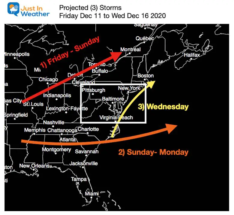
But this is 6 Days away, and there will be more adjustments. In fact, this is the 3rd event in line over the next week, with each one playing a role in the one that follows.
Busy Week Ahead
- Storm 1: Friday to Sunday this will track well north, and help to bring us temps in the 60s.
- Storm 2: Sunday to Monday will track well south and miss us.
- Storm 3 : Wednesday we ‘could’ see development off the coast after phasing with the northern Jet.
There are a lot of ‘IFs’ to get this to happen.
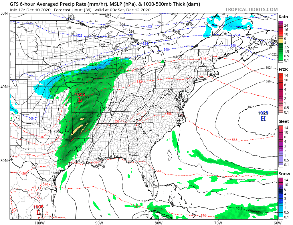
Storm Animation: GFS Model
Here is a look at the storms in motion. Note that this is just the GFS Model, and not all models have the same results.
Below we will take a closer look at the GFS timeframes, and compare to the European ECMWF and Canadian GEM Models.
Friday Evening To Wednesday Night
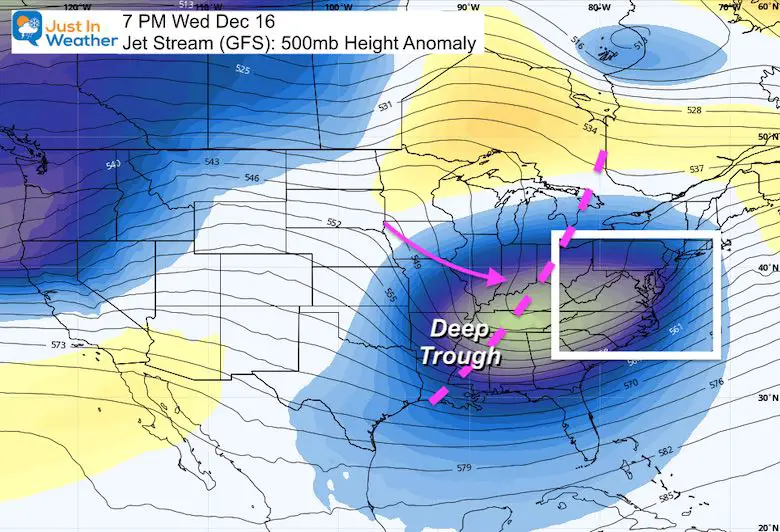
The Jet Stream Next Wednesday
A vigorous and deep trough is what is expected to allow some ‘phasing’ for the 3rd storm as a strong coastal.
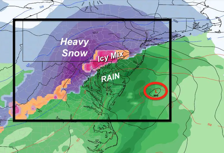
Closer Look at the GFS Model —> slider
- This is the most aggressive solution for this storm.
- See the development of steady, and even heavy snow (dark blue) that includes Baltimore, Washington, eventually Annapolis and northern Delmarva.
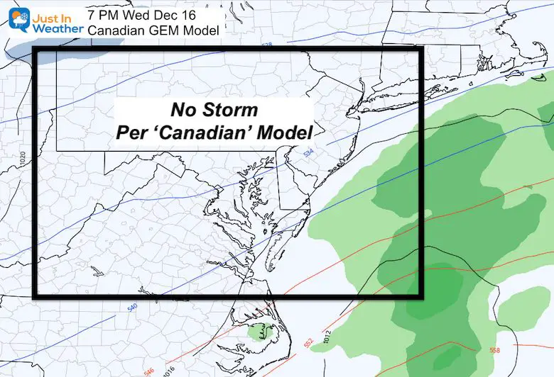
Compare this to the two other models below.


FITF Shop Open
My ‘bonus’ daughter Jaiden is showing off our popular unisex Maryland Hoodie. My wife joins her below to show of our new Ladies Hoodies.
Click here to see this and many other new items.


New Colors
We are giving 10% of each sale to Just In Power Kids: Providing FREE holistic care for pediatric oncology patients.

Winter Outlook Series


Also See:
December Climate, Sun Data, Solstice, ISS Flyovers, Moon, Planets, and The Great Conjunction

14 Local Maryland Pages (and York PA)
We have made a page for Maryland Weather which gives you the current conditions for 14 present area locations.

Maryland Weather Page
I wanted to keep it simple. Just the basics for a quick view at any time.

Please share your thoughts, best weather pics/video, or just keep in touch via social media
-
Facebook: Justin Berk, Meteorologist
-
Twitter: @JustinWeather
-
Instagram: justinweather
Email Updates
Please make sure you sign up (above or click here to sign up for email alerts…. ) for my newsletter. This way you will get an email to make sure you are notified of each post.
Just In Power Kids:
A portion of proceeds go to our programs Providing FREE holistic care for kids in cancer treatment and up to 5 years post treatment and caregivers.
![]()
New Caps and Hats

