Wednesday November 25 2020
Thursday is Thanksgiving. With early rain followed by a warm afternoon, I would have normally just given more details on that forecast. But the buzz has been growing about the winter pattern next week and I wanted to give you extra conversation material for your Zoom Holiday Dinner.
December 1st is next Tuesday, and marks the start of Meteorological Winter. Some say it’s better suited as Climatological Winter which designates the full months of December, January, and February in the season. Regardless, this year real winter weather will be in sync with the calendar. Something normal in 2020? That’s quite the surprise.
Have you ever had the feeling that something is going to happen? You were not exactly sure ‘what’, but it was noteworthy. Well, that is where the computer models are now. There is more agreement that the atmosphere will be flipping next week. The problem is, they don’t know how to handle it. I will show you below.
There are a lot of animations below, so please be patient if they are slow to load with high traffic on the server.
Click here for the Thanksgiving Morning Weather Update
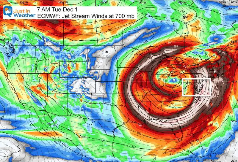
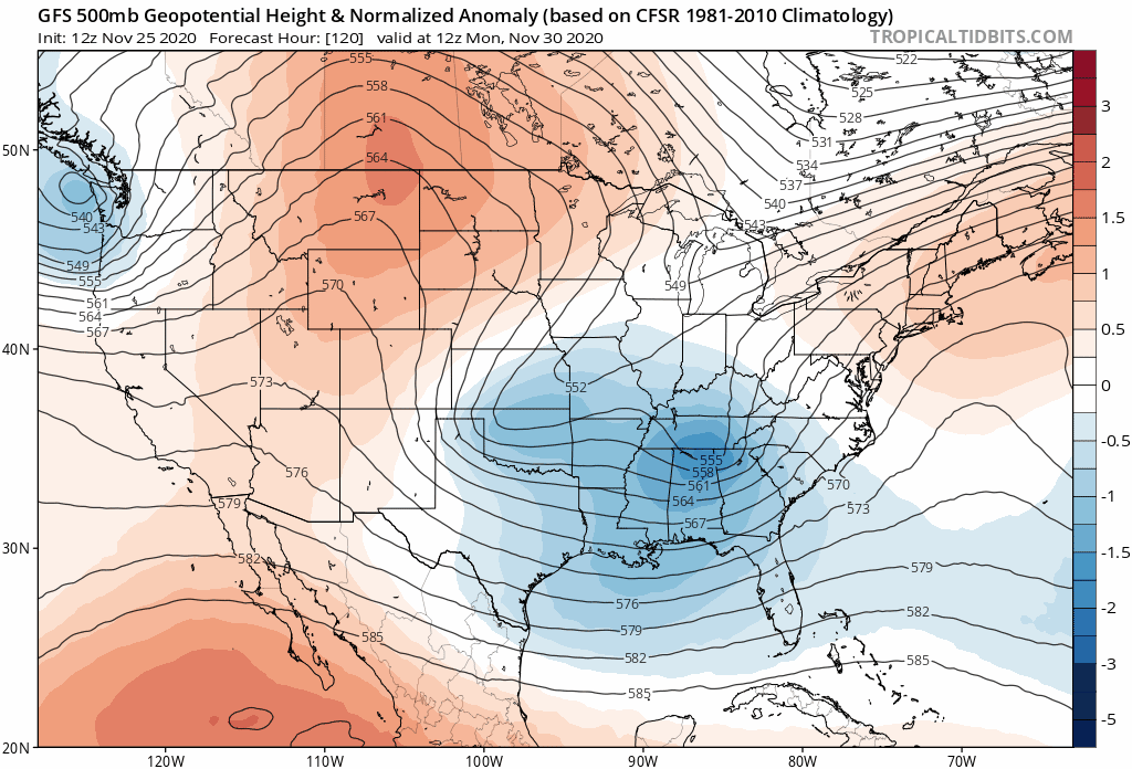
Jet Stream December 1
Oh! Or Ohio! Or Closed Low! Take your pic, this map will make most meteorologists salivate more that your best turkey and stuffing.
This map is the big show, and it shows a closed Low with cold air moving into Maryland/Pennsylvania. This air flow aloft could close off for a few days next week as the next storm passes by. What does it mean?
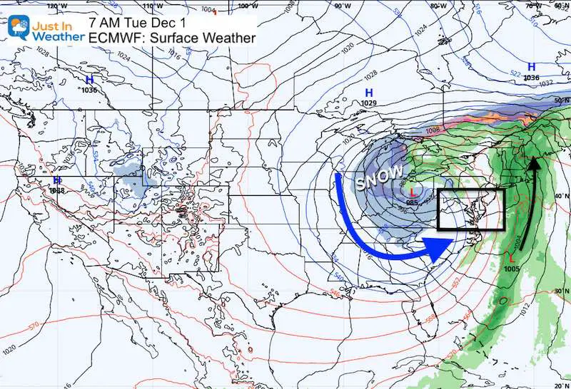
Surface Weather: Idea 1
Here is the European Model showing the rain already to our east, while snow encompasses that closed Low in Ohio. But does that mean snow for us? This is a set up that could dump in the mountains, and bring snow showers or flurries to metro areas. But that is not all we have here.
Active Weather Next Week
The idea is that with the upper level close Low, the unstable air could give rise to one or two more storms (with cold air nearby). As I wrote in the title of this post: The Models Are Going Bonkers.
BE CAREFUL WHAT YOU READ ON SOCIAL MEDIA! There are a lot of storm plots with many different looks for snow. I still would not pay attention to specifics for two reasons. 1) This is a new pattern in a new season and models don’t always handle it well. 2) NEVER trust a snow forecast more than a week away. I look and show you patterns. But any snow map is likely, almost certain to change.
I Am Not Alone
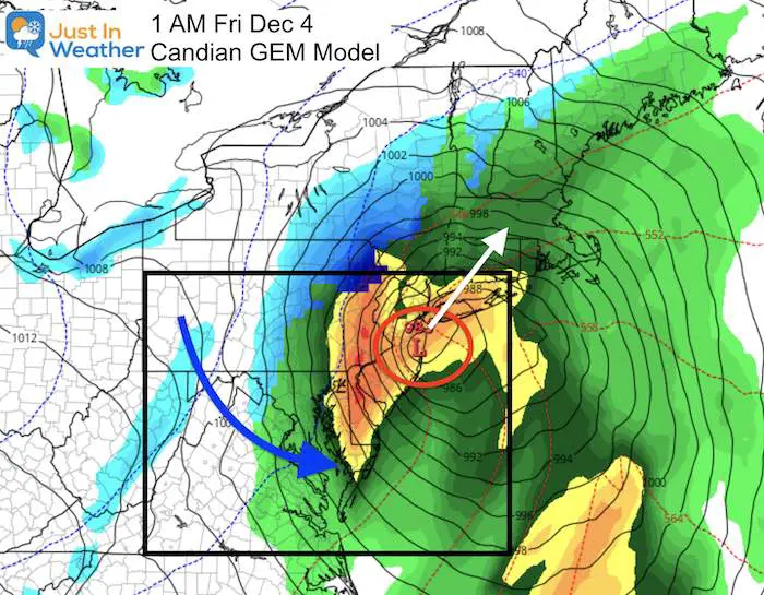
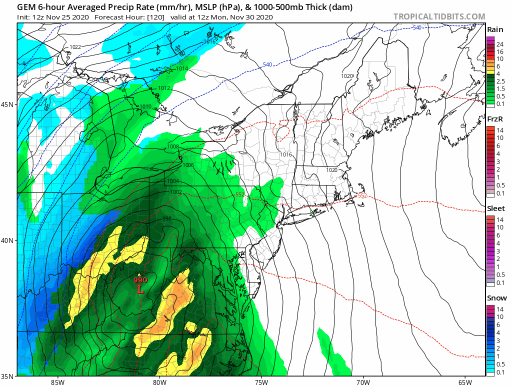
I also like to show you what some other meteorologists are thinking. Here was a tweet this morning from my friend Tony Pann. He does have a similar snow obsession as I do, but he is also cautiously optimistic. Here he is showing the Canadian GEM Model for early on Friday December 4th as it was trying to display snow for central Maryland with a coast.
With expected pattern change to “colder” here in the Mid Atlantic for early December, we’re going to start seeing the models try to make some snowstorms. This is the GEM for Dec 4th. Could this verify? Maybe! Why? Because, for a change, it will be cold enough. Stay tuned! ❄️🚂 pic.twitter.com/AOild7gADn
— Tony Pann (@TonyPannWBAL) November 25, 2020
Tony is optimistic here, but I would harp on the word Maybe! That map is 10 days away!
Soon after he posted this map, the new run of the GEM Model showed this for the same time frame: Faster with the storm and less snow on the back side.
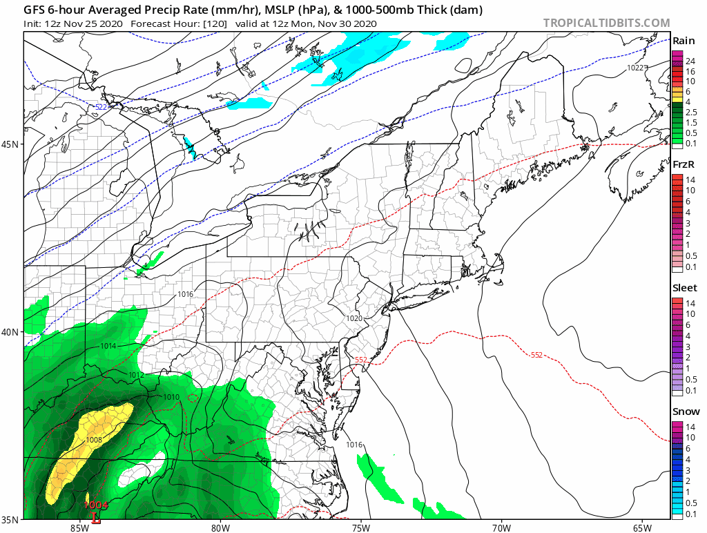
Surface Weather Idea 2: GFS Model
This all begins with the end of weekend storm forming in east Texas and coastal Louisiana. That reaches us with heavy rain Tuesday, which is when the upper level pattern closes off. That’s where things get weird.
Turn your phone sideways for a larger view.
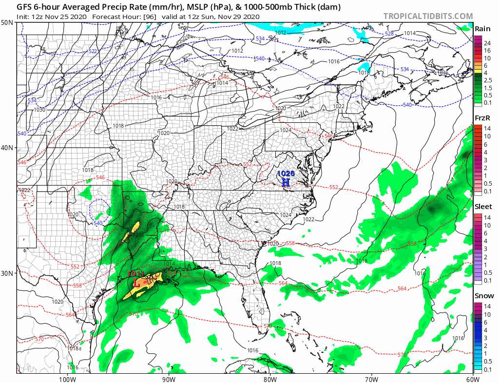
Closer Look At The GFS Model
The GFS loops a few areas of Low Pressure around our region, gradually bringing colder air in. While the snow showers (blue) may not appear to move in to central Maryland, this pattern would support flakes Thursday and Friday.
Back to The Canadian GEM Model
This model has a different solution: Two separate storms next week. Monday rain; Tuesday rain/snow showers; Thursday night into Friday rain that may end with snow for interior regions.
Back To The Jet Stream Again
This closed upper level pattern is why there is uncertainty with the surface storms.
Blue = Trough/Cold Air Aloft. The trend is for that closed Low next Tuesday to Friday. During this time that closed Low wobbles and then moves on. A second push of colder air follows by Monday December 7.
Turn your phone sideways for a larger view.
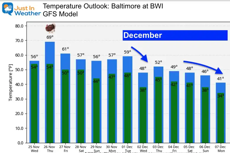
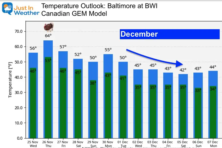
Temperature Outlooks
It is going to get colder and more wintry. The question is will be be gradual with a few surges (GFS) , or a more abrupt and sustain change (Canadian Model). Compare the forecasts here.
What To Make Of All Of This?
‘Something is going to happen’. Yes, you can quote me on that, but it’s too vague. Especially if you have Faith in the Flakes.
We know the atmosphere supports colder air, and a few storms next week. This is the best look we’ve had in a few years.
This does not promise a snow storm in metro areas, but I feel good about it for the ski areas, along with optimal snow making.
As for anything locally: We should get snow showers, flurries, and perhaps the tail end of one of those events next week to be worthy of tracking.
I NEVER forecast snow storms a week away, as they often can be fickle. But there is also a chance things get more favorable in this pattern either next week or the second week of December. It will definitely feel more like winter for a change.
FITF.
My Final Winter Outlook: Snow Forecast
FAITH IN THE FLAKES STORE OPEN
My ‘bonus’ daughter Jaiden is showing off our popular Maryland Hoodie. Click here to see this and many other new items.

New Colors
We are giving 10% of each sale to Just In Power Kids: Providing FREE holistic care for pediatric oncology patients.

Winter Outlook Series


14 Local Maryland Pages (and York PA)
We have made a page for Maryland Weather which gives you the current conditions for 14 present area locations.

Maryland Weather Page
I wanted to keep it simple. Just the basics for a quick view at any time.

Typical First Frost and Freeze

Please share your thoughts, best weather pics/video, or just keep in touch via social media
-
Facebook: Justin Berk, Meteorologist
-
Twitter: @JustinWeather
-
Instagram: justinweather
Email Updates
Please make sure you sign up (above or click here to sign up for email alerts…. ) for my newsletter. This way you will get an email to make sure you are notified of each post.
Just In Power Kids:
A portion of proceeds go to our programs Providing FREE holistic care for kids in cancer treatment and up to 5 years post treatment and caregivers.
![]()