October 31 2019
Happy Halloween! Pardon the cliche, but the weather will be tricking us today. Temperatures will be warming into the 70s through this evening, then crash to wind chills in the 20s tomorrow morning. In between, winds will be increasing! If you have decorations or kids heading out this evening, it is important to note that winds will be 25 to 40+ mph from the south even a few hours before the storm line arrives. I am the farthest thing from a weather wimp and will be out with my son this evening, but there will be a chance for branches breaking and decorations flying around. Use your judgement. If I sense it’s getting bad, we will come in quickly.
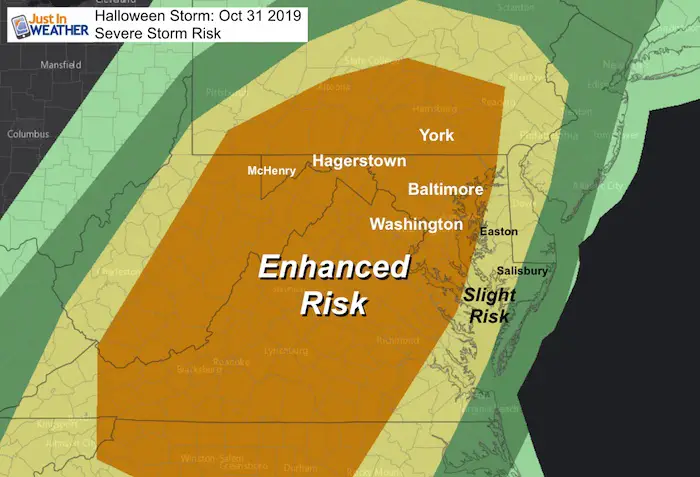
Severe Storm Risk
An Enhanced Risk for Severe Storms for our region today, but most likely after 6 PM.
Headlines
- Today: Rain Will Be Spotty At Times, Many Dry Hours
- Evening Wind: Gusts Increase 20 to 40+ mph Hours BEFORE The Intense Rain. Branches can break and decorations can fly around.
- Temperatures Warm To The Lower 70s
- Squall Line: Intense Storm Line Tracks Across Maryland AFTER 6 PM, /In Metro Areas Between 8 PM and 10 PM
- Storm Threat: Lightning, Top Wind Gusts Over 50 mph, Isolated Tornadoes
I am posting the evening conditions first for your interest. The daily weather is below.
Evening Snapshot
As of now, it looks like we will get a few hours of a ‘lull’. Computer Models suggest between 9 PM and 10 PM will be the worst conditions in metro areas (later in So. MD and Eastern Shore). My concern has been verifying a little sooner like our last few systems. So this will be close.
This could arrive 1 to 2 hours earlier, so please check back for another update this afternoon
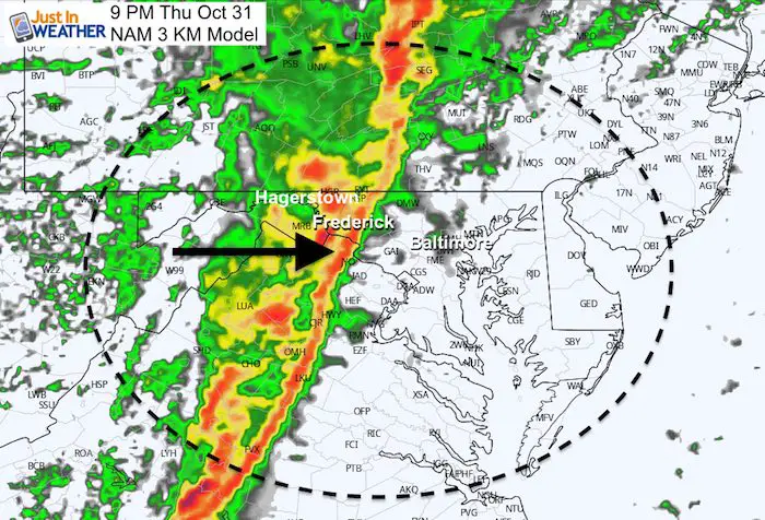
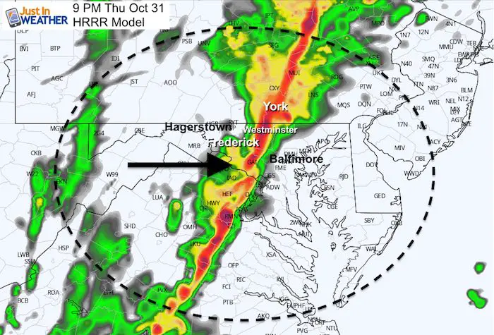
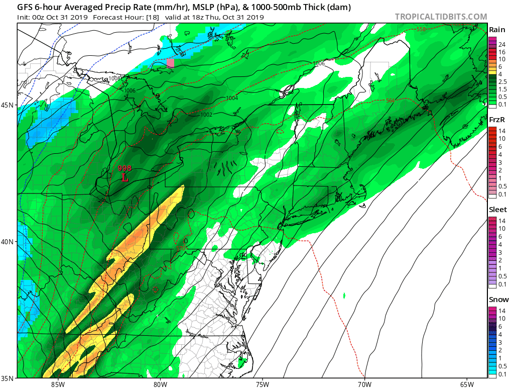
Radar Simulation
Comparing the NAM 3 Km to HRRR, and we can see the HRRR is faster passing Fredrick and hitting Westminster to York at 9 PM. But a few dry hours before this line arrives.
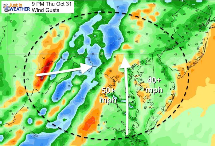
Winds
Notice the strong wind field well ahead of the storm line. Winds will be an issue long before the risk for the squall/ severe storm line/
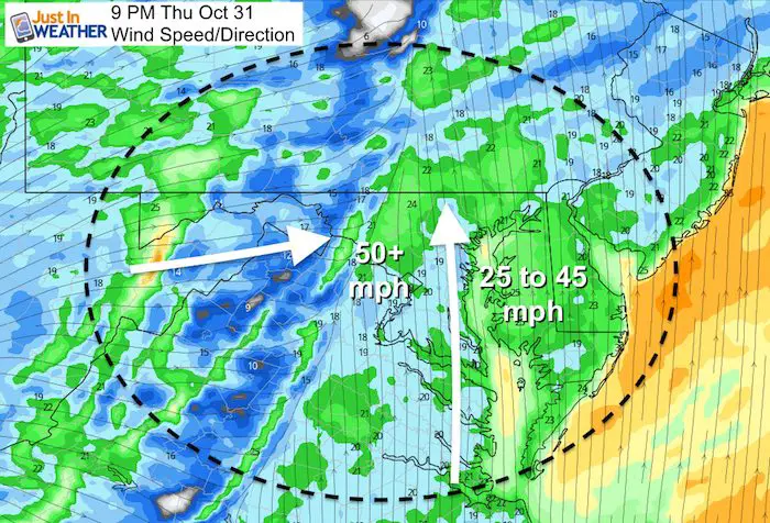
Peak Wind gusts over 50 mph with the squall line
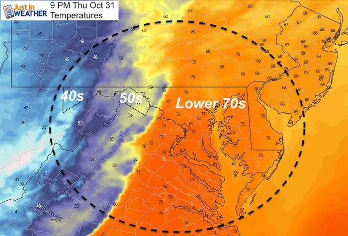
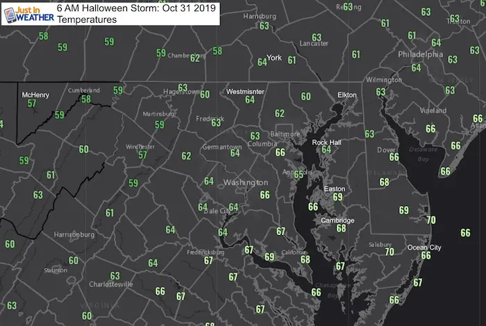
Temperatures
Local Weather Stats:
Thursday October 31, 2019 in Baltimore
Average High: 62ºF
Record High: 85ºF in 1946
Average Low: 41ºF
Record Low: 25ºF in 1966
Sunrise: 7:32 AM
Sunset 6:06 PM
*Daylight = 2:17 shorter than yesterday
*Bay Water Temperature = 63ºF at Thomas Pt. Light House
Get Forecasts By Email
Just in case you don’t get all posts on your social media feed, stay up to date with the latest info…
Click here to sign up for email alerts…. Be the first to hear any new weather
Thank you to our Title Sponsor for Maryland Trek 6
Shining on with Smyth and their contribution, our team has raised over $95,000 for Just In Power Kids to provide free programs for kids in and post cancer treatment.

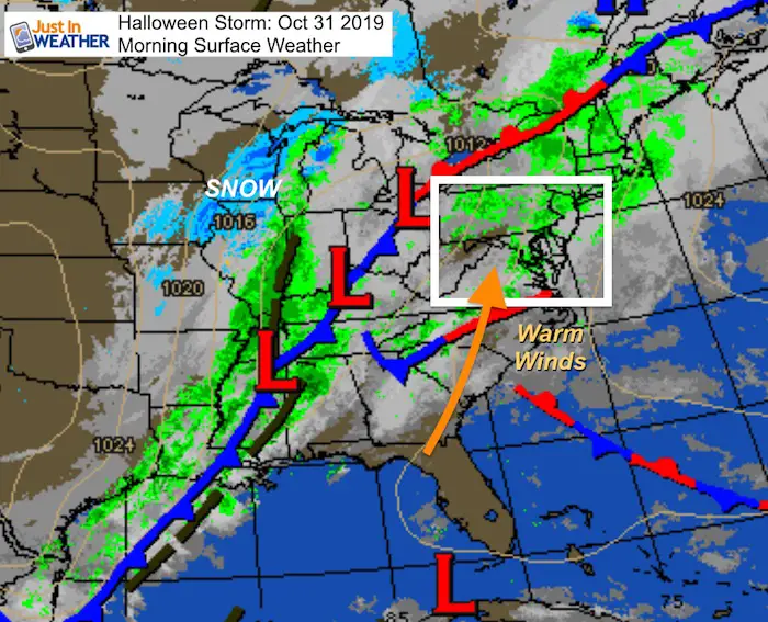
Morning Weather
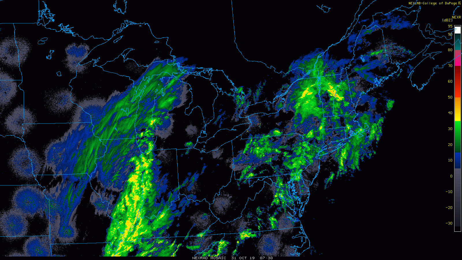
Radar Loop
The ground is wet, but the overnight rain is moving away. The main line is well to our west. So many dry hours today with spotty showers. One batch expected midday and early afternoon. Most of the daylight hours will be dry.
Temperatures
Many are already starting in the 60s. It will be warm and push into the lower 70s this afternoon–> lasting until the squall line tonight.
Storm Animation
I will post a new hourly timeline simulation this afternoon
Friday Morning
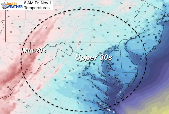
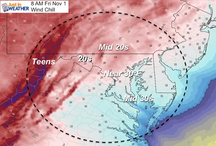
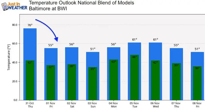
Temperature Outlook
Please share your thoughts, best weather pics/video, or just keep in touch via social media
-
Facebook: Justin Berk, Meteorologist
-
Twitter: @JustinWeather
-
Instagram: justinweather
ALL FITF Apparel Available


New Colors
We are giving 10% of each sale to Just In Power Kids: Providing FREE holistic care to pediatric oncology patients and FREE healthy meals to local hospitals.

October is Breast Cancer Awareness Month
Love Maryland Shirts and Hoodies
This shirt was designed by my ‘bonus’ daughter Jaiden. The hoodie has been the biggest hit, so our promotion is back this year. Join us to support the cause and show off your Love of Maryland
|
||
|
Show your love for Maryland and make this 15 year old artist and her mom extra proud
|


Also See:
NOAA Winter Outlook Leaves Room For More Snow With Mild ‘Seasonal Average’ Temperatures

Many areas inland from the cities should drop into the 30s by tomorrow morning. This could do it.
See the maps for when we normally expect the first frost in this link.

Snowy Winters Following A Hot and Dry September

Baltimore Weather At BWI May Not Be As Hot As Reported
Construction at the airport close to the weather station may be added artificial heat. Click here or the image for the details.

Other Links:
Atmospheric Memory Shaped The US East Coast
Atmospheric Memory Of Hurricanes Over Thousands Of Years Shaped The Coast

Was Your County Not Included?
Click this map for more on the regional forecast zones

Maryland Trek Cycle Jerseys From Hill Killer
All proceeds will go to the Maryland Trek 6 total and Just In Power Kids programs

Just In Power Kids:
Proceeds go to our programs Providing FREE holistic care for kids in cancer treatment and up to 5 years post treatment and caregivers.
![]()
Shine On
Proceeds from all sales go to Just In Power Kids. Click the image to shop and show your support.
