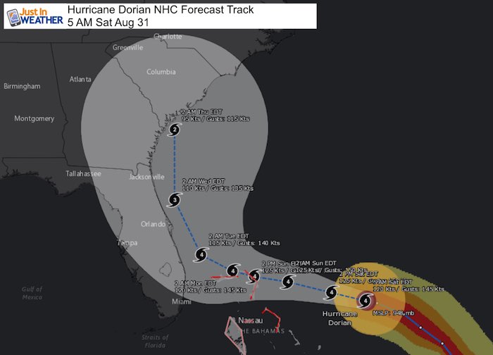
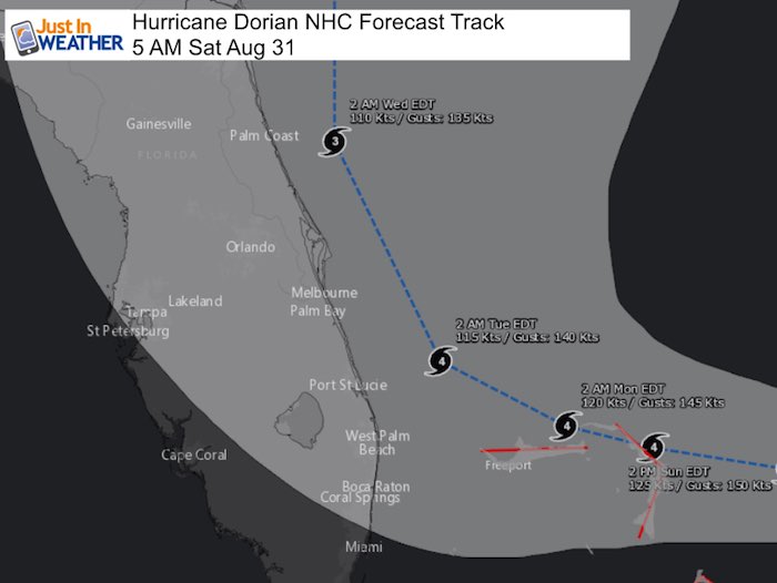
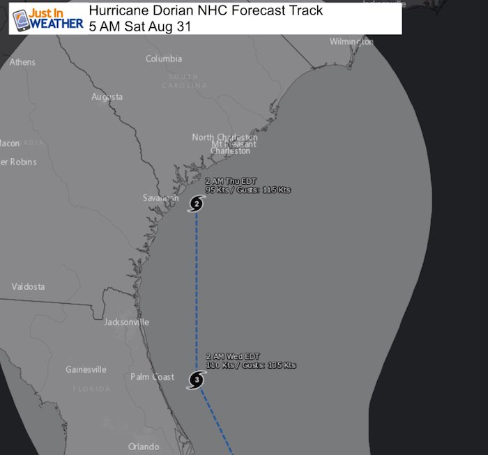
Saturday August 31 2019
Last night Hurricane Dorian reached Category 4 intensity. This morning is has winds of 140 mph, which is holding from 11 PM last night. This is a very impressive looking storm that has continued to be stronger and farther north that forecasts. The timing of the movement AND intensity is what has changed the forecast when it approaches Florida, but actually puts it back to what was thought a few days ago…
UPDATE AT 8 AM(Click for new report and maps): Winds 145 mph and new models shift track a little farther north
Dorian is now expected to turn up the Florida coast and puts South and North Carolina in play for landfall. See why and many forecast maps below.
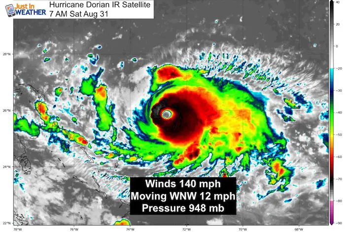
Hurricane Dorian IR Satellite
Hurricane Dorian Headlines
- Winds 140 mph
- Tropical Storm Winds extend 105 miles form the center
- Hurricane Fore Winds extend 30
- Bahamas expecting deadly 15 Ft Storm Surge and up to 20 inches of rain
- Forecast turns north before Florida, but storm surge and impact still along the coast with rain, winds, and high waves!
- Many airports in Florida planning to close due to stronger winds aloft
- Forecast for South and North Carolina landfall still needs to be considered not a sure thing yet
- Ocean City: Forecast curves east by over 150 miles on Friday. Rain and wind from outer bands could reach there Thursday. Still worth watching for adjustment
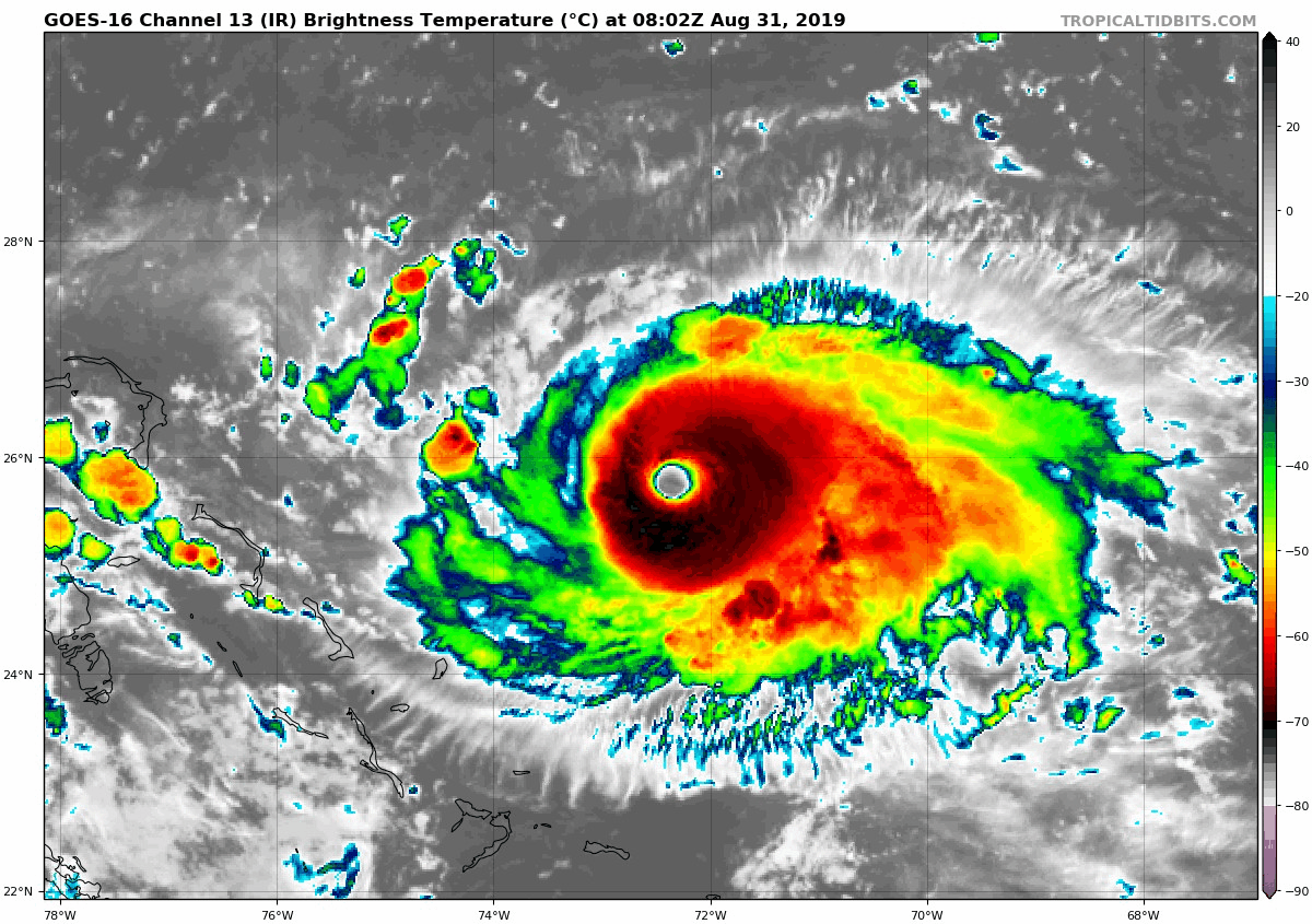
Hurricane Dorian Satellite Loop
Dorian has gotten dry air into the west (front) side of the storm. This has held further development. There will be more fluctuations in intensity this weekend as Dorian experiences an eye wall replacement cycle.
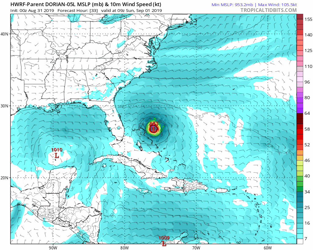
SUMMARY OF 500 AM EDT...0900 UTC...INFORMATION ---------------------------------------------- LOCATION...25.8N 72.6W ABOUT 470 MI...755 KM E OF WEST PALM BEACH FLORIDA ABOUT 305 MI...490 KM E OF THE NORTHWESTERN BAHAMAS MAXIMUM SUSTAINED WINDS...140 MPH...220 KM/H PRESENT MOVEMENT...WNW OR 290 DEGREES AT 12 MPH...19 KM/H MINIMUM CENTRAL PRESSURE...948 MB...28.00 INCHES Forecast Shifting There are many factors that go into the forecast track, and forward movement. This includes the strength of the storm, but also the weather systems in the US that will interact with it when it arrives.HWRF Hurricane Model Forecast
European Model Forecast ---> slider [metaslider id=79349]
 European Model Forecast ---> slider
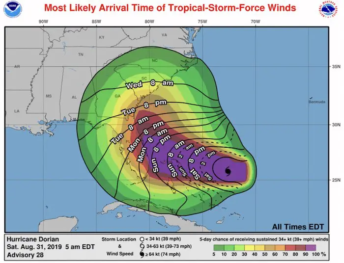
Wind Arrival Time
Tropical Storm Fore Intensity Over 39 mph. The timing is still the same Sunday night into Monday for coastal Florida, but Tuesday and Wednesday for South Carolina. This will be a day or more ahead of the core of the Dorian’s eye.
National Hurricane Forecast Tracks
These maps were made to zoom in closer. Please cone of uncertainty. As seen already, the center is likely NOT to be where this ends up… But farther out in time there will be more factors to shift where this ends up.
National Hurricane Official Full Forecast Track/Cone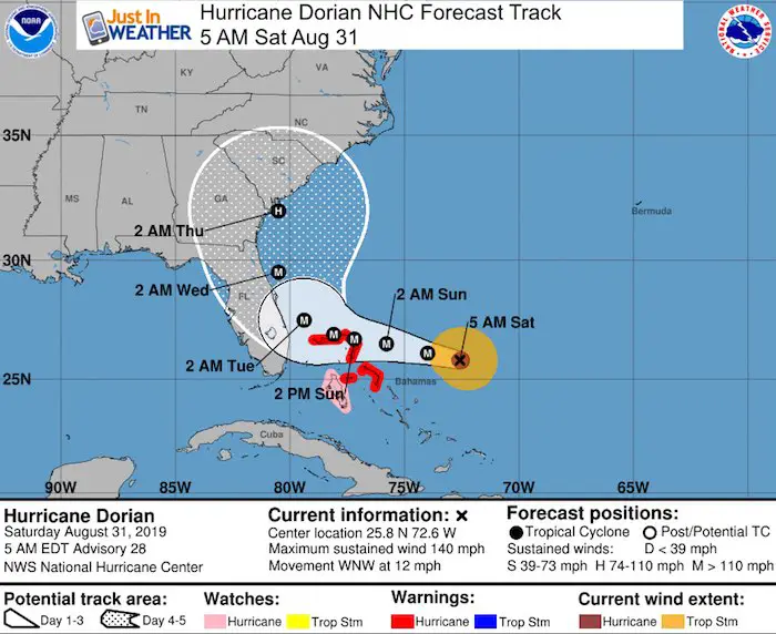
A Hurricane Warning is in effect for...
* Northwestern Bahamas excluding Andros Island

A Hurricane Watch is in effect for...
* Andros Island

A Hurricane Warning means that hurricane conditions are expected
somewhere within the warning area.  A warning is typically issued
36 hours before the anticipated first occurrence of tropical-storm-
force winds, conditions that make outside preparations difficult or
dangerous.  Preparations to protect life and property should be
rushed to completion.

A Hurricane Watch means that hurricane conditions are possible
within the watch area.  A watch is typically issued 48 hours before
the anticipated first occurrence of tropical-storm-force winds,
conditions that make outside preparations difficult or dangerous.
Keep In Touch Every Day
Just in case you don’t get all posts on your social media feed, stay up to date with the latest info…
Click here to sign up for email alerts…. Be the first to hear any new weather
Thank you to our Title Sponsor for Maryland Trek 6
Shining on with Smyth and their contribution, our team has raised over $95,000 for Just In Power Kids to provide free programs for kids in and post cancer treatment.

Please share your thoughts, best weather pics/video, or just keep in touch via social media
-
Facebook: Justin Berk, Meteorologist
-
Twitter: @JustinWeather
-
Instagram: justinweather
Maryland Trek Cycle Jerseys From Hill Killer
All proceeds will go to the Maryland Trek 6 total and Just In Power Kids programs

Just In Power Kids:
Proceeds go to our programs Providing FREE holistic care for kids in cancer treatment and up to 5 years post treatment and caregivers.
![]()
Shine On
Proceeds from all sales go to Just In Power Kids. Click the image to shop and show your support.

Love Maryland Shirts and Hoodies
This shirt was designed by my ‘bonus’ daughter Jaiden. The hoodie has been the biggest hit, so our promotion has been extended until the end of this week.
|
||
|
Show your love for Maryland and make this 14 year old artist and her mom extra proud
|


Related Links:
Was Your County Not Included?
Click this map for more on the regional forecast zones
