Sunday April 14 2019
A severe storm outbreak in the south yesterday is still heading our way. This morning the large system is bringing a line of thunderstorms across the Gulf Coast to Atlanta. But on the other end, snow is falling from Detroit to Chicago and and around St. Louis. That cold air is adding energy into the jet stream that will keep this system pulsing with destructive potential as it moves in our direction.
Most of today should be quiet, until mid afternoon. Severe storms are possible in our area in two pulses. One this afternoon/evening, then again tonight. These may contains winds over 58 mph, large hail over size of a quarter, and isolated tornadoes. Yes, snow will also follow in the western Maryland mountains Monday morning.

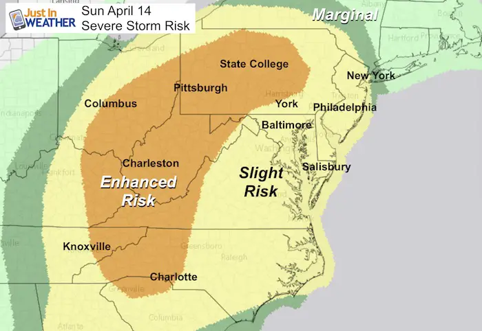
Severe Storm Potential
There is some explaining with this map, but the main issue is that this system has looked stronger which means we have a better chance for severe weather today. Western Maryland is part of the Enhanced Risk, with the most intense line of storms arriving there before midnight.
Most of our region across metro Baltimore to southern PA and Delmarva now are in the Slight Risk for severe storms. We will have two rounds of storms: First mid afternoon, then again overnight after midnight. The good news is that the intense line may weaken overnight when it arrives but still pack a strong punch.
Severe Alert Notes:
IF we get any severe weather alerts, this is what is most important to keep in mind:
A WATCH means it MIGHT happen
A WARNING means it IS HAPPENING NOW! This can be tracked across counties and towns with more precision and need to seek strong shelter.
Local Weather Stats For April 14, 2019 in Baltimore
Average High: 64ºF
Record High: 91ºF in 1941
Average Low: 42ºF
Record Low: 24ºF in 1950
*Record Snow: = 0.4″ in 1940
Sunrise: 6:31 AM
Sunset 7:42 PM
*Daylight = 2:28 longer than yesterday
*Bay Water Temperature = 55ºF at Thomas Pt. Light House
Keep In Touch Every Day
Just in case you don’t get all posts on your social media feed, stay up to date with the latest info…
Click here to sign up for email alerts…. Be the first to hear any new weather.
Maryland Trek 6
Our look got an upgrade, but we have the same purpose. Please click the logo take a look at our new page.
- Consider joining our team for the week, a single day, or even as a sponsor.


New Partner
Buchanan Kia of Westminster is a supporter of Just In Power Kids and Maryland Trek 6 in August 2019.
Saturday Morning:
Mild start. There has been some fog and will be mostly clouds skies remaining.

Afternoon High Temperatures
There is a chance we get some breaks of sun, but temps will be warm in the 70s for most of the region.

Sunday Rain Timeline—> slider
There will be one wave of showers and storms developing this afternoon. The first wave will need to be watched between 2 PM and 6 PM. There is a chance some turn severe, but the main energy will be with the line arriving tonight. Western Maryland could get this between 10 PM and midnight.
[metaslider id=75700]

Monday Rain Timeline—> slider
We could have more severe storms overnight. Central Maryland will get in on this between 1 AM and 4 AM. This will be arriving with less heat and weakening from their peak during the day today,. But tonight could be still bring loud storms with damaging winds.
[metaslider id=75719]
Temperatures Monday Afternoon

Please share your thoughts, best weather pics/video, or just keep in touch via social media
-
Facebook: Justin Berk, Meteorologist
-
Twitter: @JustinWeather
-
Instagram: justinweather
Related Links:
Was Your County Not Included?
Click this map for more on the regional forecast zones
