Saturday April 14 2019
You want it, we’ve got it in Maryland this weekend. After bands of heavy rain overnight passed through, this morning we have areas of fog and lingering showers. Today we track the leftover showers in parts of the state, but temperatures will warm to the 70s. Then on Sunday we may have some showers, but a severe storm outbreak to our southwest could stretch our way overnight into Monday morning. At that point, the back end of the storm will bring some heavy snow to the mountains of western Maryland.
Severe Storm Outbreak Today: Southern US
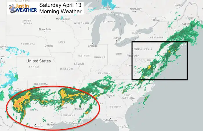
The rain locally will continue to move to the south and east, lingering on the lower Eastern Shore. More on that in a moment. But most of today But the storm developing in Texas is the main focus. Strong energy in the jet stream will eject to the east and erupt in the afternoon.
Severe Storm Outlook Today
The main focus will be east of Dallas and north of New Orleans. This ‘Moderate Risk’ area has a very good chance for a tornado outbreak and very large hail. That is the energy that will try to head our way at the end of the weekend.
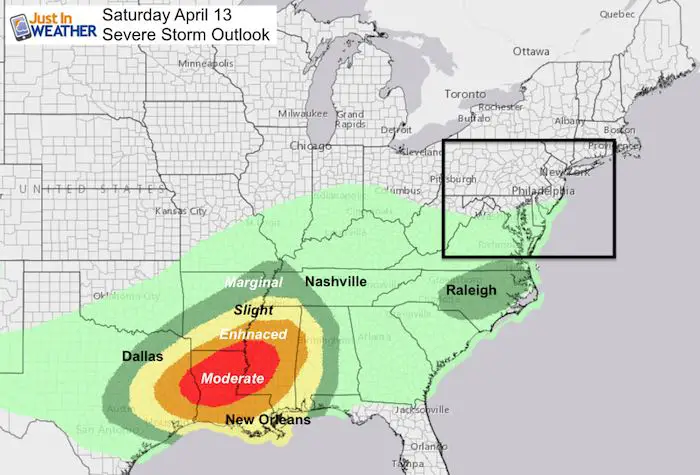
Severe Storm Risk Sunday (into early Monday Morning)

Local Weather Stats For April 13, 2019 in Baltimore
Average High: 64ºF
Record High: 89ºF in 1977
Average Low: 42ºF
Record Low: 26ºF in 1973
*Record Snow: = 0.4″ in 1957
Sunrise: 6:32 AM
Sunset 7:41 PM
*Daylight = 2:28 longer than yesterday
*Bay Water Temperature = 52ºF at Thomas Pt. Light House
Keep In Touch Every Day
Just in case you don’t get all posts on your social media feed, stay up to date with the latest info…
Click here to sign up for email alerts…. Be the first to hear any new weather.
Maryland Trek 6
Our look got an upgrade, but we have the same purpose. Please click the logo take a look at our new page.
- Consider joining our team for the week, a single day, or even as a sponsor.


New Partner
Buchanan Kia of Westminster is a supporter of Just In Power Kids and Maryland Trek 6 in August 2019.
Saturday Morning:
The rain as of 8 AM was still pretty heavy, just south and east of Annapolis. This is the band we were concerned with stalling this weekend. There appears to be enough push to move this another 50 to 100 miles to the east.
It should improve from Kent Island to Easton gradually this morning.

Rain Timeline Today —> slider
Turn you phone sideways for a larger view
The rain should break apart, but keep the risk of showers in southern Maryland. There is a small chance some passing showers will ride up the western shore of the Bay mid afternoon. I would not change your plans at this point, but be prepared that you might get wet briefly.
[metaslider id=75656]
High Temperatures Today

Low Temperatures Sunday

High Temperatures Sunday

Sunday Rain?
As it looks now, there may be some showers in the morning as shown here.

But the bulk of the day will be dry. Some showers will erupt in the afternoon, but it will be Sunday night and Monday morning we need to focus on.
Severe Storm Risk Sunday?
I need to explain that this also includes Sunday night into Monday morning before sunrise. That is where our role in this plays out.
Sunday Night/Monday: Storm and Snow Timeline —> slider
The remains of severe storms that develop Sunday will reach us AFTER MIDNIGHT into Monday morning.
Notice the snow in the mountains Monday morning. Yes, the maybe some stickage and accumulation in Garrett County to Snowshoe, WV
[metaslider id=75673]
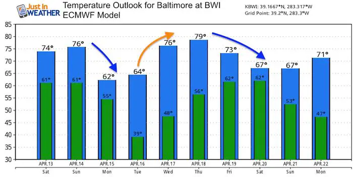
Temperature Outlook
Locally we should remain mild… with 60s our coolest days Monday and Tuesday next week.
Please share your thoughts, best weather pics/video, or just keep in touch via social media
-
Facebook: Justin Berk, Meteorologist
-
Twitter: @JustinWeather
-
Instagram: justinweather
Related Links:
Was Your County Not Included?
Click this map for more on the regional forecast zones
