Wednesday April 10 2019
If you have not had the chance to look outside since the sun set yesterday, the sky has been brilliant with stars. That is a sign of dry air and also cool temperatures, which was inevitable after two days in the 80s. BWI hit 84ºF on Monday and 80ºF yesterday. This morning might feel chilly, especially inland away from the city. Check out the numbers this morning. The afternoon will behave a little more like mid April.

Maryland Statewide Tornado Drill
Wednesday April 10, 2019 at 9:45 AM
If you get message of a tornado Wednesday morning, please note that it is a planned drill from NWS and MDEME as part of Maryland Severe Storm Awareness Week. See more about this here.
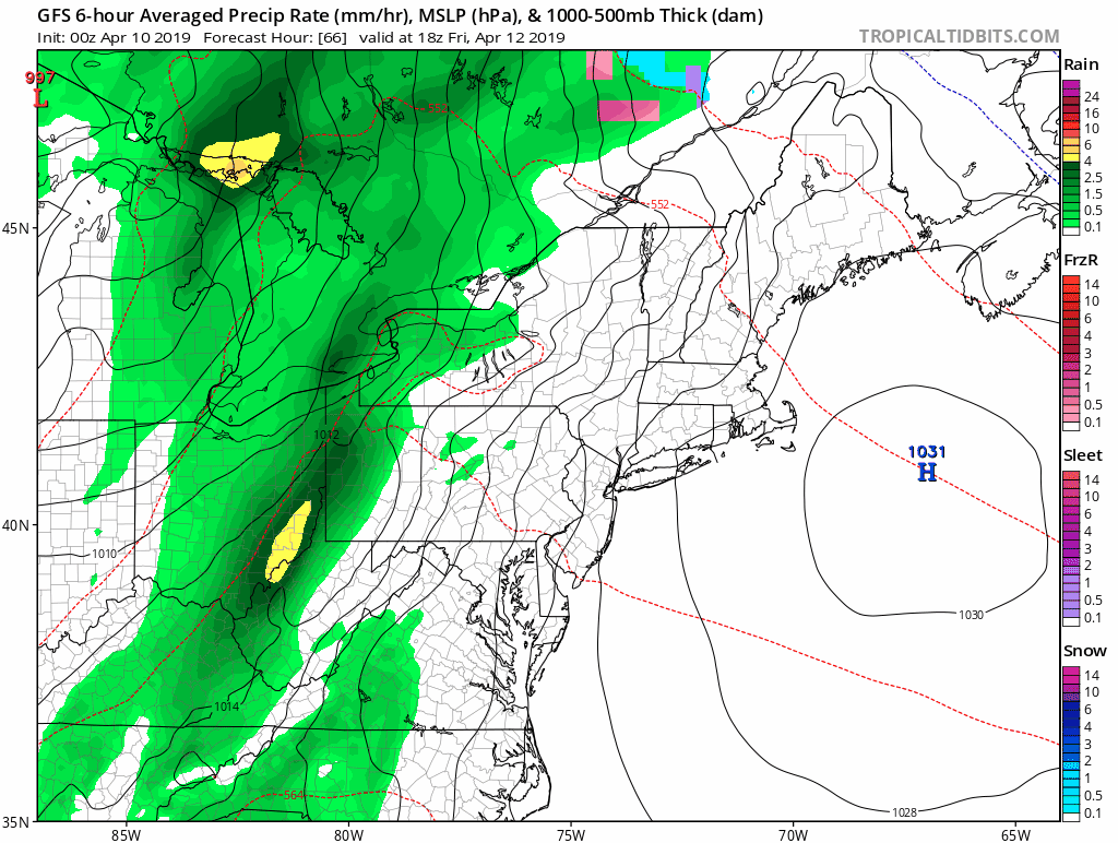
The next weather event may be two that blend together. We expect a storm to bring rain Friday evening and possibly thunderstorms overnight into Saturday morning. There is an indication now that we could have showers redevelop Saturday afternoon and evening. Then the next storm will bring showers Sunday afternoon and evening with heavier rain Monday into Tuesday. See the animation below.
Local Weather Stats For April 10, 2019 in Baltimore
Average High: 63ºF
Record High: 91ºF in 2013
Average Low: 41ºF
Record Low: 22ºF in1985
*Record Snow: = 3.0″ in 1894
Sunrise: 6:37 AM
Sunset 7:38 PM
*Daylight = 2:30 longer than yesterday
*Bay Water Temperature = 52ºF at Thomas Pt. Light House
Keep In Touch Every Day
Just in case you don’t get all posts on your social media feed, stay up to date with the latest info…
Click here to sign up for email alerts…. Be the first to hear any new weather.
Maryland Trek 6
Our look got an upgrade, but we have the same purpose. Please click the logo take a look at our new page.
- Consider joining our team for the week, a single day, or even as a sponsor.


New Partner
Buchanan Kia of Westminster is a supporter of Just In Power Kids and Maryland Trek 6 in August 2019.
Weather All About Temperatures Next Two Days
High Temperatures Wednesday

Low Temperatures Thursday

High Temperatures Thursday

Low Temperatures Friday Morning

Rain Animation: Two separate storms may blend together
- Friday: Showers develop after noon and evening. Heavy rain overnight.
- Saturday: Rain ends in the morning, some afternoon showers
- Sunday: Afternoon showers, then steady rain overnight
- Monday: Rain will be heavy at times
Rainfall Potential

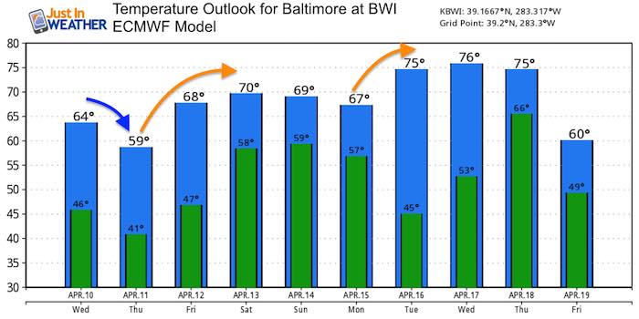
Temperature Outlook
Sustainable warmer air looks to settle in next week.
Please share your thoughts, best weather pics/video, or just keep in touch via social media
-
Facebook: Justin Berk, Meteorologist
-
Twitter: @JustinWeather
-
Instagram: justinweather
Related Links:
Was Your County Not Included?
Click this map for more on the regional forecast zones
