Wednesday February 27 2019
Temperatures have chilled down and will remain cold for a while. The next two days will be quiet, but we are still expecting a little snow on Friday morning. This will be a weak system but timing out around sunrise so that it could have some travel impact. It still looks like between a dusting and 2 inches of snow is possible. The problem is that the array of computer models are having trouble locking in on this and a very active weather pattern through next week. March will be coming in like a lion.
This morning the pattern is split. The outlook will combine forces for us to get more active weather next week.
- Northern branch: Snow rising the through the Great Lakes into New England.
- Southern brach: Rain across the Gulf Coast

Friday Snow Notes
?Not a major storm.
?Dusting to 2 inches, mostly early morning Friday
?Slick roads possible Friday morning
?School delays❓
❄️Ends by mid-day Friday
Compare the computer model maps below
Local Weather Stats For February 27, 2019 in Baltimore
Average High: 48ºF
Record High: 76ºF in 1997
Average Low: 29ºF
Record Low: 9ºF in 1934
*Record Snow: = 3.5″ in 1940
Sunrise: 6:42 AM
Sunset 5:56 PM
*Daylight = 2:31 longer than yesterday
*Bay Water Temperature = 39ºF at Thomas Pt. Light House
Keep In Touch Every Day
Just in case you don’t get all posts on your social media feed, stay up to date with the latest info…
Click here to sign up for email alerts…. Be the first to hear any new weather.

New Partner
Buchanan Kia of Westminster is a supporter of Just In Power Kids and Maryland Trek 6 in August 2019.
Morning Temperatures

Afternoon Highs

Thursday Afternoon Highs

Friday Morning Low Temperatures
Where the snow falls, it will be cold enough to stick

Friday Morning Snow
The NAM Model does appear to be the most aggressive. It tends to do that, but I have seen it lead the charge with a few event this year that earned it some credit. Compare this to other models below.
Friday Morning Computer Model Comparison


European Model

GFS Model

Canadian GEM Model

Friday Snow Notes
?Not a major storm.
?Dusting to 2 inches, mostly early morning Friday
?Slick roads possible Friday morning
?School delays❓
❄️Ends by noon Friday
I will continue to update this with a better chance for snow potential this afternoon
Outlook
This weekend: Another storm is likely top bring us rain
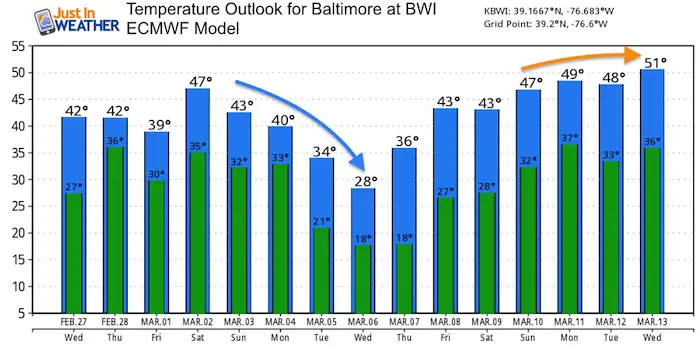
Next Week: A few storms but the computer modeling is all over the place. It would be a disservice to show you them now without any consistency of timing and type of ‘stuff’ that will fall. Why I feel comfortable showing you is the jet stream that will be dominated by a cold flow. That also has energy to bring multiple weather systems for the first week of March
Blue: Colder than climatological average
Temperature Outlook
ALL FITF Apparel

Please share your thoughts, best weather pics/video, or just keep in touch via social media
-
Facebook: Justin Berk, Meteorologist
-
Twitter: @JustinWeather
-
Instagram: justinweather

New Colors
We are giving 10% of each sale to Just In Power Kids: Providing FREE holistic care for pediatric oncology patients.

Related Links:
Winter Outlook
My Winter Outlook 2018-19: Multiple Nor’Easters and more snow

Was Your County Not Included?
Click this map for more on the regional forecast zones

Interactive Snow Report
November 15 Snow Reports- Interactive Map Compared To My Forecast

Winter Snow And Top 5 Wet Years
Snowfall Seasons at Beginning and End of Top 5 Wet Years In Baltimore

Related Winter Outlooks
Solar Cycle: When Sun Spots Are Low We Get More Snow
El Nino Modoki May Enhance Snow Chances
Sweet Spot: Hitting 70ºF on Halloween is followed by more winter snow
Will A Wet Summer Bring A Snowy Winter?
NOAA Winter 2018-2019 Outlook Explained: This Actually Supports Snow
Winter Outlook From Two Different Farmers Almanacs
Maryland Winters: Snowfall Maps and Baltimore Snow History
