Saturday February 16 2019
Today is the anniversary of the second largest February single day snow. The super storm of 2003 dropped 21.8″ of snow on Baltimore on this date. Today, light snow will stay well south. That has the plan for a few days and I hope you have been getting my updates. That storm plus some showers Sunday are part of an entire colder shift with the pattern that includes the larger storm next week. Next Wednesday still looks like the main event, and the colder pattern brings in more snow before changing over to freezing rain. So another potential ice storm for the areas that just had one this past week.
This morning you will notice the cold air has returned. The outlook for the next month has some very cold air dominating the country, and we will be on the edge of this. That means we will continue to fluctuate between warm days and winter weather events. More on that below.

Local Weather Stats For February 15, 2019 in Baltimore
Average High: 45ºF
Record High: 75ºF in 1954
Average Low: 27ºF
Record Low: 5ºF in 2015
*Record Snow: 21.8″ in 2003 *2nd highest for the month
Sunrise: 6:58 AM
Sunset 5:43 PM
*Daylight = 2:23 longer than yesterday
*Bay Water Temperature = 38ºF at Thomas Pt. Light House
Keep In Touch Every Day
Just in case you don’t get all posts on your social media feed, stay up to date with the latest info…
Click here to sign up for email alerts…. Be the first to hear any new weather.

New Partner
Buchanan Kia of Westminster is a supporter of Just In Power Kids and Maryland Trek 6 in August 2019.
Morning Temperatures

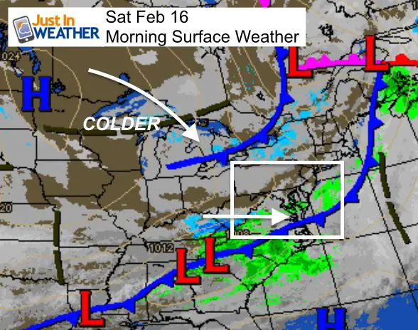
Where is the snow?
As we discussed a few days ago, the system is weaker and staying south. There may be some wintry mix showers in southern Maryland, but most likely in southern Virginia. Do not expect any stickage.

Afternoon Forecast

Weekend Max/Min Temperatures —> slider
[metaslider id=73304]
Sunday Evening Showers?
At this point, it look light. Any mix will be only a few hours and temperatures appear to remain above freezing.

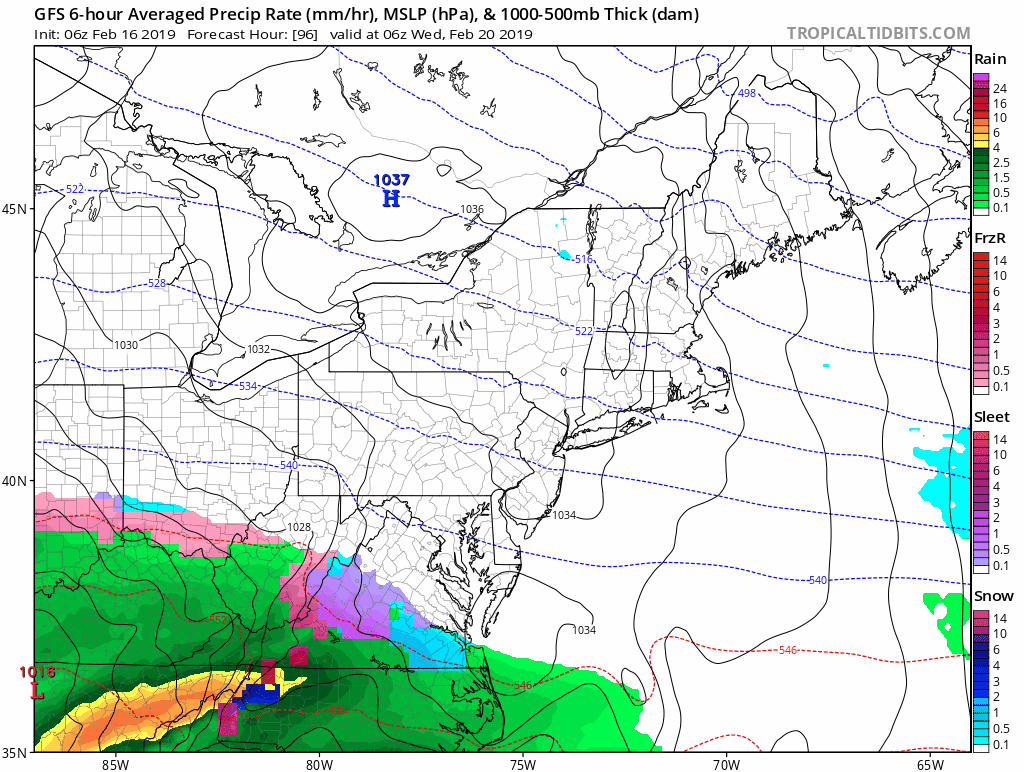
Storm Next Week
- At this time, the storm appears to arrive Wednesday morning. As mentioned, the colder set up brings us snow before the change to freezing rain.
- Snow should fall for most of our area as it begins, but change to rain quickly for southern MD and east of the Bay to most of Delmarva.
- I DO NOT give snow totals more than 48 hours ahead of an event. Too much can change, especially with timing the change to ice. So any totals you see now elsewhere are likely to change.
- The most likely ice storm areas are the places that just had extensive ice and snow this past week. This is west and north of I-95 and the cities. Problems will linger into Wednesday night and Thursday morning.
- Note: Most ice events tend to last longer than models initially show
GFS Model Animation
The bulk of the snow will fall during the day Wednesday, then change to freezing rain west and north of the cities/I-95
European Model —> slider
[metaslider id=73311]
ALL FITF Apparel

Outlooks
NOAA’s Climate Prediction has among the coldest February signatures even shown…
2 week outlook
This shows the core of the cold air in the western US. Our region is on the edge of slightly mild, with summer heat in Florida.
But, we are on the edge and will get some influence from both air masses. Warm days and cold air with some winter weather events.

Early March Outlook

Ten Day Outlook
Here we can see the bounce between mild and cold temporaries over the next week and a half for Baltimore.

Please share your thoughts, best weather pics/video, or just keep in touch via social media
-
Facebook: Justin Berk, Meteorologist
-
Twitter: @JustinWeather
-
Instagram: justinweather

New Colors
We are giving 10% of each sale to Just In Power Kids: Providing FREE holistic care for pediatric oncology patients.

Related Links:
Winter Outlook
My Winter Outlook 2018-19: Multiple Nor’Easters and more snow

Interactive Snow Report
November 15 Snow Reports- Interactive Map Compared To My Forecast

Winter Snow And Top 5 Wet Years
Snowfall Seasons at Beginning and End of Top 5 Wet Years In Baltimore

Related Winter Outlooks
Solar Cycle: When Sun Spots Are Low We Get More Snow
El Nino Modoki May Enhance Snow Chances
Sweet Spot: Hitting 70ºF on Halloween is followed by more winter snow
Will A Wet Summer Bring A Snowy Winter?
NOAA Winter 2018-2019 Outlook Explained: This Actually Supports Snow
Winter Outlook From Two Different Farmers Almanacs
Maryland Winters: Snowfall Maps and Baltimore Snow History
