Friday February 15 2019
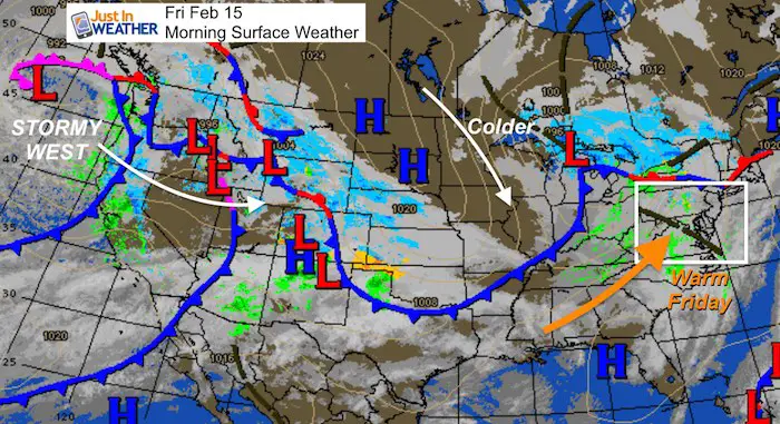
I was downplaying the snow on Saturday and now it appears even southern Maryland will get less. The warm air today will be replaced by a cool down, but the force that will bring back winter will shift the snow south. But if you remember the next systems on Sunday evening… That will be south as well. So there could be some minor impact a the end of the weekend.
The southern shift also adjusts the potential for the storm next week. The result there could bring in a little more snow. before the change over to the dreaded ice storm. Here is a brief look.
Morning Snapshot
- The warm up for us will last one day. Colder air is will will spark the snow Saturday…
- The western US remains very stormy. Some of that energy is what we expect to bring us ice and snow next week.
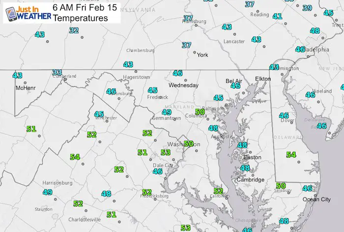
Temperatures: Already A Warm Start For Some
- Much of central and southern Maryland start in the upper 40s to near 50ºF.
- Souther PA starts in the 30s, but will warm up quickly.
Local Weather Stats For February 15, 2019 in Baltimore
Average High: 45ºF
Record High: 77ºF in 1949
Average Low: 27ºF
Record Low: 6ºF in 2015
*Record Snow: 11.5″ in 1976
Sunrise: 6:58 AM
Sunset 5:43 PM
*Daylight = 2:23 longer than yesterday
*Bay Water Temperature = 37ºF at Thomas Pt. Light House
Keep In Touch Every Day
Just in case you don’t get all posts on your social media feed, stay up to date with the latest info…
Click here to sign up for email alerts…. Be the first to hear any new weather.

New Partner
Buchanan Kia of Westminster is a supporter of Just In Power Kids and Maryland Trek 6 in August 2019.
This Afternoon

Saturday: Snow Shifts South
Instead of the snow with wet roads I discussed yesterday, this looks like lighter snow for southern Maryland with little stickage on the grass.
More snow metro Richmond, VA.. But I would still expect wet roads.

Sunday:
- The bulk of showers that was expected to be in PA, has shifted south into central Maryland. Notice the freezing line will be crossing I-95 in central Maryland. So we might need to consider how quickly the ground can cool for any icing overnight into Monday morning.
- The amount falling will be light.

Next Week: This Storm Looks To Start Colder and Farther South As Well
Here is the latest European Model showing light snow beginning early Wednesday morning. This shows a longer period of snow in our area followed by freezing rain later Wednesday, overnight, and into Thursday morning on the north side.
This is still 5 days away, so not a lock. The storm has consistently be a featured element, but I would expect some wiggle room. That is why I do not give specifics… just follow the trend at this point.
ECMWF Model — > slider
[metaslider id=73281]
Temperature Outlook
Plenty of ups and downs, but the overall average will be near to below average

ALL FITF Apparel

Please share your thoughts, best weather pics/video, or just keep in touch via social media
-
Facebook: Justin Berk, Meteorologist
-
Twitter: @JustinWeather
-
Instagram: justinweather

New Colors
We are giving 10% of each sale to Just In Power Kids: Providing FREE holistic care for pediatric oncology patients.

Related Links:
Winter Outlook
My Winter Outlook 2018-19: Multiple Nor’Easters and more snow

Interactive Snow Report
November 15 Snow Reports- Interactive Map Compared To My Forecast

Winter Snow And Top 5 Wet Years
Snowfall Seasons at Beginning and End of Top 5 Wet Years In Baltimore

Related Winter Outlooks
Solar Cycle: When Sun Spots Are Low We Get More Snow
El Nino Modoki May Enhance Snow Chances
Sweet Spot: Hitting 70ºF on Halloween is followed by more winter snow
Will A Wet Summer Bring A Snowy Winter?
NOAA Winter 2018-2019 Outlook Explained: This Actually Supports Snow
Winter Outlook From Two Different Farmers Almanacs
Maryland Winters: Snowfall Maps and Baltimore Snow History
