February 14 2019
We finally started to turn mild on this Valentines Day afternoon, and a big warm up is expected tomorrow. The snow is still set for this weekend, but all things thing to be factored in. This quick post may help answer some questions about what to expect. This is only about the Saturday event. The over main weather issue will be a large ice storm next week, which I will update in my evening post.
Before The Snow…
Friday will be warm! Especially in the areas that are expecting snow, the afternoon highs will be in the lower 60s. Some 50s by the water
Friday’s High Temperatures

It would take time to cool the ground, even if we had a major chill, but we will not.
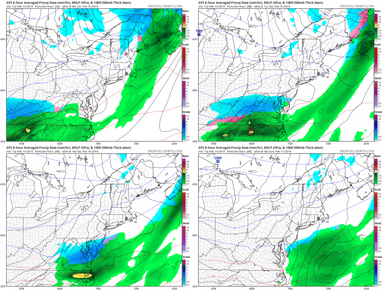
Here is the expected track of the snow on the GFS Model. (compare to local slider for the GFS and European Models below)
GFS Model —> slider
- Some snow near Washington in the morning. Maybe light snow or flurries near Baltimore. Little to nothing north of there.
- If to arrives before 8 AM, there may be some minor impact around metro Washington and Annapolis until 10 AM.
- It will be colder under the moderate snow, and milder to the north.
- The area of near freezing will be narrow, and specific to the snow rates.
- Stickage will be marginal, and more likely on the grass.
- Most roads likely to be wet due to daytime snowfall. But can get slushy and covered at times.
[metaslider id=73259]
Saturday Afternoon Temperatures

European Model —> slider
[metaslider id=73267]
Saturday Afternoon Temperatures

My Notes:
- It will be colder under the moderate snow, and milder to the north.
- The area of near freezing will be narrow, and specific to the snow rates.
- Stickage will be marginal, and more likely on the grass.
- Most roads likely to be wet due to daytime snowfall. But can get slushy and covered at times.
How Much Snow?
Between 2 and 4 inches may fall in the moderate snow zone. That is well south of Baltimore and Washington. But I expect most will be on the grass.
I will have another update this evening.
Keep In Touch Every Day
Just in case you don’t get all posts on your social media feed, stay up to date with the latest info…
Click here to sign up for email alerts…. Be the first to hear any new weather.
New Partner
Buchanan Kia of Westminster is a supporter of Just In Power Kids and Maryland Trek 6 in August 2019.
ALL FITF Apparel
Please share your thoughts, best weather pics/video, or just keep in touch via social media
-
Facebook: Justin Berk, Meteorologist
-
Twitter: @JustinWeather
-
Instagram: justinweather
New Colors
We are giving 10% of each sale to Just In Power Kids: Providing FREE holistic care for pediatric oncology patients.
Related Links:
Winter Outlook
My Winter Outlook 2018-19: Multiple Nor’Easters and more snow
Interactive Snow Report
November 15 Snow Reports- Interactive Map Compared To My Forecast
Winter Snow And Top 5 Wet Years
Snowfall Seasons at Beginning and End of Top 5 Wet Years In Baltimore
Related Winter Outlooks
Solar Cycle: When Sun Spots Are Low We Get More Snow
El Nino Modoki May Enhance Snow Chances
Sweet Spot: Hitting 70ºF on Halloween is followed by more winter snow
Will A Wet Summer Bring A Snowy Winter?
NOAA Winter 2018-2019 Outlook Explained: This Actually Supports Snow
Winter Outlook From Two Different Farmers Almanacs


