Thursday February 14 2019
Happy Valentines Day. You may love that it is not snowing. You may love that temps could warm to 60 degrees tomorrow. Or, you may love that snow on the way this weekend will reach southern Maryland. But I doubt many can find the love for a potential ice storm next week. There is a lot to discuss but here is a quick break down, with maps below.

Quick Cast
- Valentines Day: Some morning ice, warming to the upper 40s
- Friday: Warming to 50s. Near 60ºF between Baltimore and Washington
- Saturday: Snow southern Maryland, but during the day many roads will be wet
- Sunday: Light evening showers
- Ice Storm: Tuesday Night and Wednesday
Forecast Maps Below
Local Weather Stats For February 14, 2019 in Baltimore
Average High: 45ºF
Record High: 70ºF in 1990
Average Low: 26ºF
Record Low: -2ºF in 1979
*Record Snow: 4.0″ in 1976
Sunrise: 6:59 AM
Sunset 5:41 PM
*Daylight = 2:21 longer than yesterday
*Bay Water Temperature = 36ºF at Thomas Pt. Light House
Keep In Touch Every Day
Just in case you don’t get all posts on your social media feed, stay up to date with the latest info…
Click here to sign up for email alerts…. Be the first to hear any new weather.

New Partner
Buchanan Kia of Westminster is a supporter of Just In Power Kids and Maryland Trek 6 in August 2019.
Two Days To Thaw
Today

Friday

Weekend Snow
This appears to be holding a track through the southern half of Maryland. M<ost paling during the day will likely mean stickage on the grass, but most roads wil be wet.
Euro Model —> slider
[metaslider id=73233]
GFS FV3
This shows snow mostly south of Washington on to Maryland’s lower Eastern Shore.

Sunday Evening
This wave appears to be light showers. Not a big deal at this time for us. Steady snow or mix into central and western PA.

Ice Storm: Tuesday Night into Wednesday
This is still on track as it looked for a few days. Cold air at the surface but warmer air aloft.
This could be a moderate impact Wednesday morning in metro areas. Might be a major extended ice event inland and up north again.
Euro Model —> slider
[metaslider id=45768]
GFS FV3
This model is later and colder. While it shows snow at the onset, it turns to ice for the evening.

Notes: I lean in favor of the Euro Model for both events…. Which means the weekend event will be a minor impact. However next week might be worth having a back up plan. The timing can change, but Tuesday night and Wednesday it is important to remember that ice storms often last longer than initially shown on models.
ALL FITF Apparel

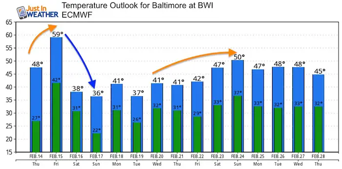
Extended Temperatures
The second half of next week trends back closer to normal (mid to upper 40s).
Please share your thoughts, best weather pics/video, or just keep in touch via social media
-
Facebook: Justin Berk, Meteorologist
-
Twitter: @JustinWeather
-
Instagram: justinweather

New Colors
We are giving 10% of each sale to Just In Power Kids: Providing FREE holistic care for pediatric oncology patients.

Related Links:
Winter Outlook
My Winter Outlook 2018-19: Multiple Nor’Easters and more snow

Interactive Snow Report
November 15 Snow Reports- Interactive Map Compared To My Forecast

Winter Snow And Top 5 Wet Years
Snowfall Seasons at Beginning and End of Top 5 Wet Years In Baltimore

Related Winter Outlooks
Solar Cycle: When Sun Spots Are Low We Get More Snow
El Nino Modoki May Enhance Snow Chances
Sweet Spot: Hitting 70ºF on Halloween is followed by more winter snow
Will A Wet Summer Bring A Snowy Winter?
NOAA Winter 2018-2019 Outlook Explained: This Actually Supports Snow
Winter Outlook From Two Different Farmers Almanacs
Maryland Winters: Snowfall Maps and Baltimore Snow History
