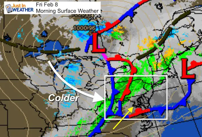
Friday February 8 2019
There are showers and some fog to start this Friday, and this morning may be the warmest part of the day. A cold front will be moving through later this morning across metro Baltimore. A little later for the Delmarva. The winds will shift, and temperatures will hold steady or drop this afternoon. Then much colder air on the way this weekend. This will set up a two part winter event for Monday and Tuesday.
I’ve packed a lot of maps below to help break this down. I will have more details on the storm beginning in my evening report.
Daily Weather Highlights
Maps for these events are below.
- Today: Morning showers. Temps falling this afternoon.
- Weekend: Mostly dry and cooler. Saturday may stay below freezing for most of the region. Wind chills in the teens and 20s.
- Sunday overnight into Monday Morning: Some light snow.
- Monday evening into Tuesday: Snow mixing to ice then rain
Is it too early to get excited for a winter storm?
- This thing has not formed yet! So the location and timing is up for debate.
- Agreement: Some snow Monday, but then more impact snow and ice on Tuesday.
- The timing of the heavier snow, ice, and rain I what is not locked in yet.
- Check out this contrast and see the maps below
Euro
This shows two impact times:
- Monday morning mainly north of Rt 50. Then thawing.
- Tuesday morning. The second event could lead to more ice into the afternoon and evening in the colder northern counties.
| 7 AM Mon | 7 AM Tue |
 |
 |
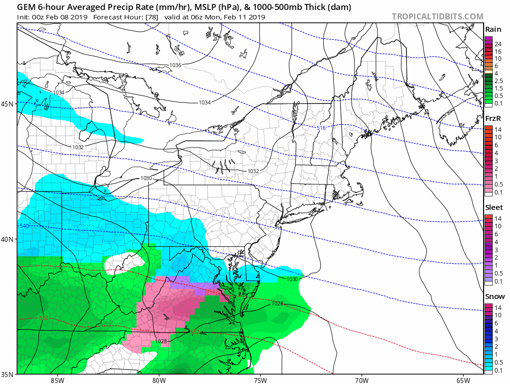
Canadian GEM
This models shows the impact from snow extended farther south to include metro Washington, Annapolis, and Southern Maryland.

See more maps below
Local Weather Stats For February 8, 2019 in Baltimore
Average High: 43ºF
Record High: 72ºF in 2017 (records two days in a row)
Average Low: 26ºF
Record Low: 6ºF in 1895
*Record Snow: 6.3″ in 1974
Sunrise: 7:06 AM
Sunset 5:35 PM
*Daylight = 2:15 longer than yesterday
*Bay Water Temperature = 36ºF at Thomas Pt. Light House
Keep In Touch Every Day
Just in case you don’t get all posts on your social media feed, stay up to date with the latest info…
Click here to sign up for email alerts…. Be the first to hear any new weather.

New Partner
Buchanan Kia of Westminster is a supporter of Just In Power Kids and Maryland Trek 6 in August 2019.
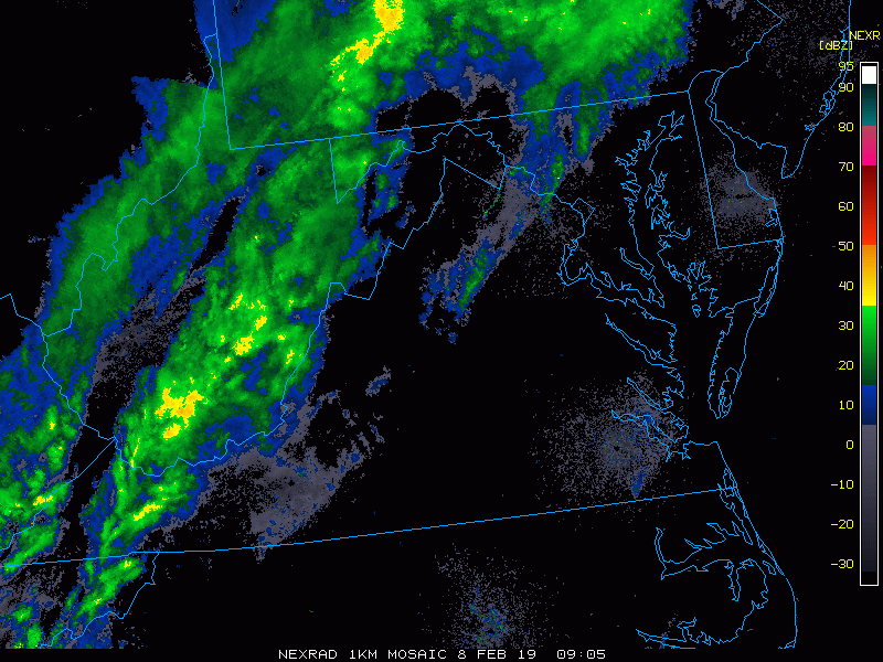
Morning Radar Loop
Cold Front Arrives Late Morning

Temperatures
Morning

Afternoon

Colder Weekend
This is important to cool the ground down after our recent warm week. After the weekend, any snow or ice that falls will have a better chance for stickage
Saturday Morning

Saturday Afternoon

Two Part Storm:
The accepted solution now: Light snow may impact Monday morning. Then a break and maybe a thaw, followed by a second round of snow and ice Monday night into Tuesday.
- Freezing line? How far south may be impacted is still up for debate. If you are near or north of Rt 50, there is better reasons to expect an impact. Metro Washington, Annapolis, and southern Maryland to Delmarva should watch updates for any wiggle room.
- Ice Lingers Longer: Colder zones NorthWest of Baltimore may hold the ice longer into Tuesday. Models often bring in a thaw too early with this type of set up.
- How Much Snow? It is too early to say, especially since we don’t have a lock on the freezing line or transition from snow to ice.
Storm Animation
The Canadian Model shows more impact farther south.
European Model —> slider
This shows the freezing line closer to Rt 50. Notice the ice lingering longer in northern Maryland and southern PA Tuesday evening.
[metaslider id=72667]

New Colors
We are giving 10% of each sale to Just In Power Kids: Providing FREE holistic care for pediatric oncology patients.

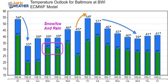
Temperature Outlook
Notes:
Monday and Tuesday: The model shows highs above freezing, but look at the lows at 31ºF. Looking deeper, this model supports the snow with colder temps Monday night into mid day Tuesday. So the highs are before and after the snow portion shown in the slider above.
Warm up after Valentines Day, then colder again.
Please share your thoughts, best weather pics/video, or just keep in touch via social media
-
Facebook: Justin Berk, Meteorologist
-
Twitter: @JustinWeather
-
Instagram: justinweather
FITF and SnowStix

Related Links:
Winter Outlook
My Winter Outlook 2018-19: Multiple Nor’Easters and more snow

Interactive Snow Report
November 15 Snow Reports- Interactive Map Compared To My Forecast

Winter Snow And Top 5 Wet Years
Snowfall Seasons at Beginning and End of Top 5 Wet Years In Baltimore

Related Winter Outlooks
Solar Cycle: When Sun Spots Are Low We Get More Snow
El Nino Modoki May Enhance Snow Chances
Sweet Spot: Hitting 70ºF on Halloween is followed by more winter snow
Will A Wet Summer Bring A Snowy Winter?
NOAA Winter 2018-2019 Outlook Explained: This Actually Supports Snow
Winter Outlook From Two Different Farmers Almanacs
Maryland Winters: Snowfall Maps and Baltimore Snow History
