Thursday February 7 2019
We are still on the cool side of this frontal boundary, but it is trying to move back north. The result will bring some light scattered showers, but most of the day will be dry. While there will be some warmer air tomorrow morning, we will cool back down this weekend. Then we set the stage for a new winter weather event. I do have FITF for more snow, but the way this will play out is still uncertain. What I do believe is that we need to expect some impact from snow Sunday night into Monday and then more snow and ice on Tuesday.

Daily Weather Highlights
Maps for these events are below.
- Today: Mostly dry, just a few showers. Temps bear 50ºF
- Friday: High temps by noon. Mid day rain, then cooling
- Weekend: Mostly dry and cooler
- Sunday night into Monday: Some light snow
- Monday evening into Tuesday: Snow mixing to ice then rain
Is it too early to get excited for a winter storm?
- This thing has not formed yet! So the location and timing is up for debate.
- Agreement: Some snow Monday, but then more impact snow and ice on Tuesday.
- The timing of the heavier snow, ice, and rain I what is not locked in yet.
- Check out this contrast and see the maps below
Euro
This shows the largest snow impact by sunrise Tuesday. Then rain Tuesday afternoon.
| 1 AM Tue | 1 PM Tue |
 |
 |
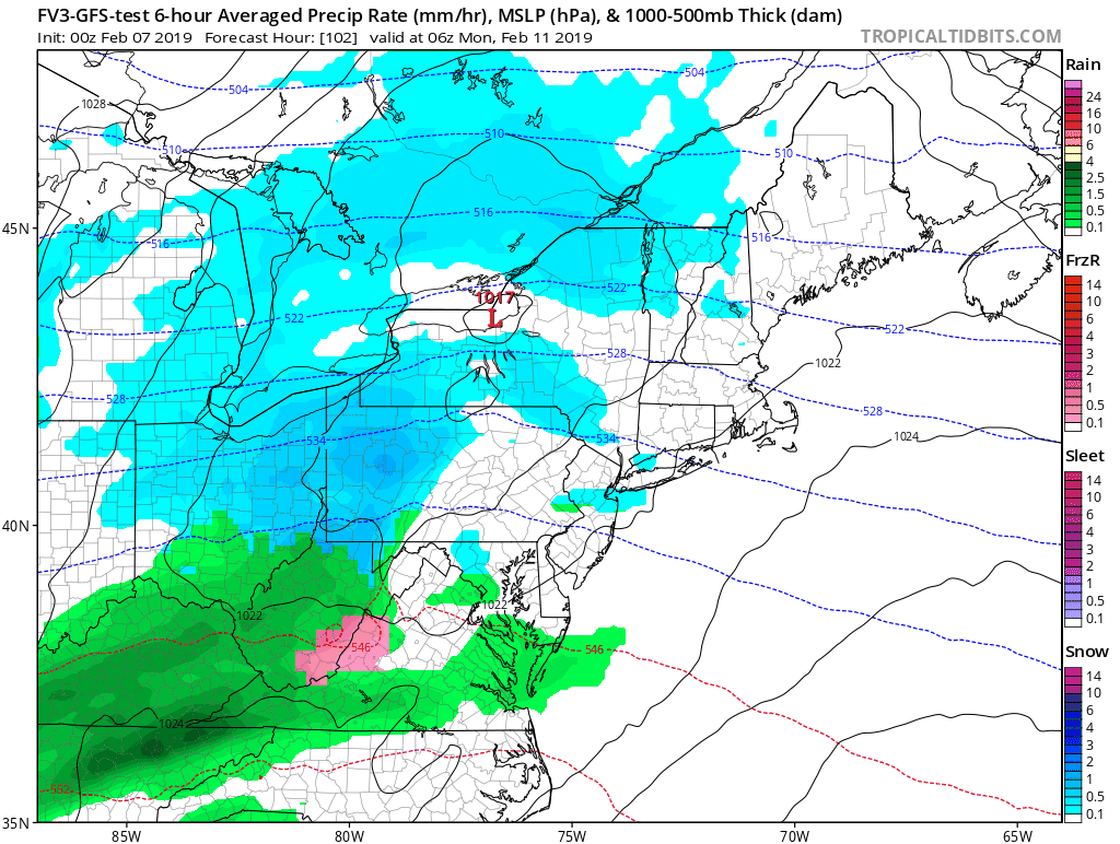
FV3-GFS
This model shows the storm developing Tuesday afternoon and night.

See more maps below
Local Weather Stats For February 7, 2019 in Baltimore
Average High: 43ºF
Record High: 72ºF in 2017
Average Low: 25ºF
Record Low: 6ºF in 1895
*Record Snow: 10.1″ in 1967
Sunrise: 7:07 AM
Sunset 5:33 PM
*Daylight = 2:14 longer than yesterday
*Bay Water Temperature = 36ºF at Thomas Pt. Light House
Keep In Touch Every Day
Just in case you don’t get all posts on your social media feed, stay up to date with the latest info…
Click here to sign up for email alerts…. Be the first to hear any new weather.

New Partner
Buchanan Kia of Westminster is a supporter of Just In Power Kids and Maryland Trek 6 in August 2019.
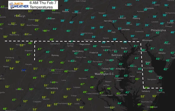
Morning Snapshot
Temperatures
That front really stands out….
- 30s in PA
- 40s in central MD
- 50s in VA and WV
Morning Radar Loop
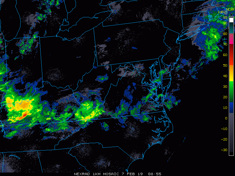
Radar Simulation —> slider
[metaslider id=72618]
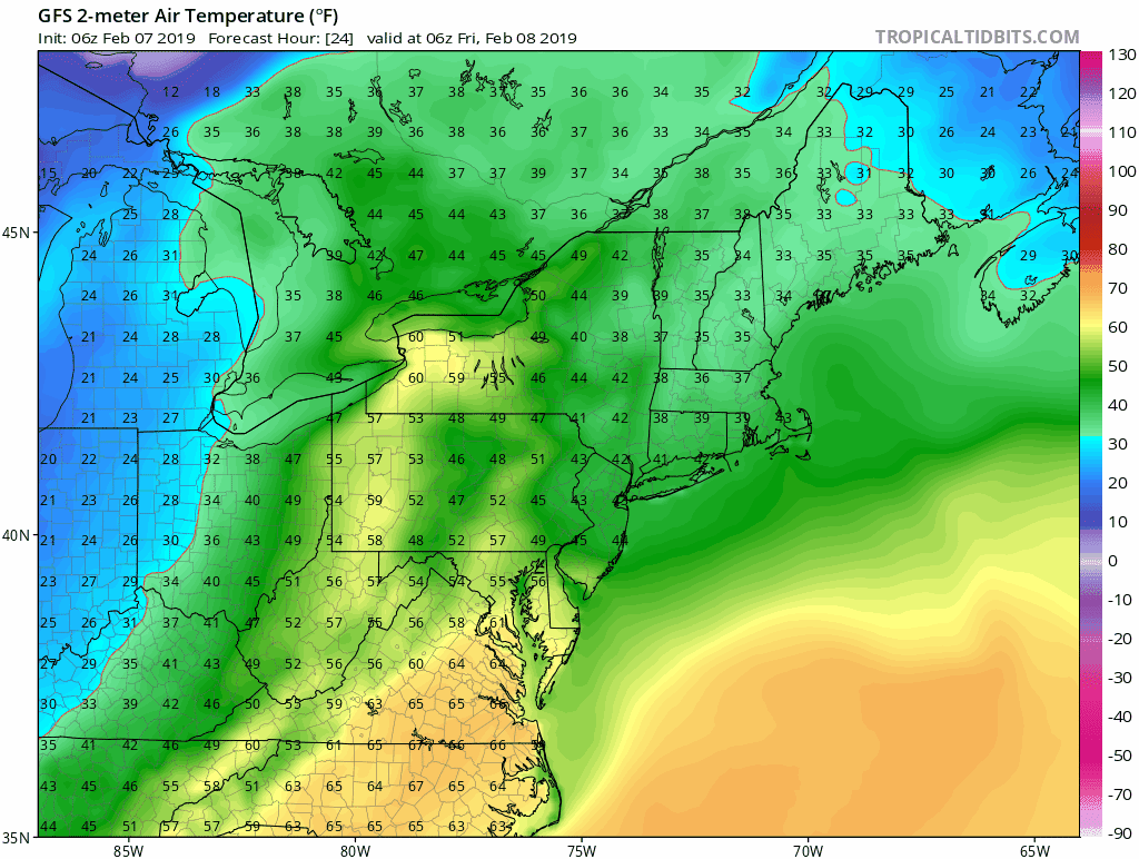
Afternoon High Temps

Friday

Skipping To The Storm
Compare the timing of snow, ice, and rain between the European (ECMWF) and American Model (FV3-GFS)
How Much? It is too early for anyone to suggest how much we could get. Especially since the timing, track, and transition to ice and snow are not certain.
I would still keep your plans in mind to possibly be affected Sunday night into Tuesday night.
European Model —> slider
This model shows light snow Sunday night and Monday. Then the main storm Tuesday morning turning to rain Tuesday afternoon and Wednesday.
[metaslider id=72637]
Storm Animation: FV3- GFS
This model shows the snow and ice just developing on Tuesday, then turn to rain by Wednesday morning.

New Colors
We are giving 10% of each sale to Just In Power Kids: Providing FREE holistic care for pediatric oncology patients.

Temperature Outlook
Notes:
Friday’s high temperature should be before noon.
Monday and Tuesday: The model shows highs above freezing, but look at the lows at 31ºF. Looking deeper, this model supports the snow with colder temps Monday night into mid day Tuesday. So the highs are before and after the snow portion shown in the slider above.
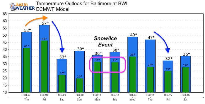
Temperature Trend: GFS Model
Even with some mild surges, there is plenty of cold air waiting to return. Valentine’s Day looks to start another cold spell.
Please share your thoughts, best weather pics/video, or just keep in touch via social media
-
Facebook: Justin Berk, Meteorologist
-
Twitter: @JustinWeather
-
Instagram: justinweather
FITF and SnowStix

Related Links:
Winter Outlook
My Winter Outlook 2018-19: Multiple Nor’Easters and more snow

Interactive Snow Report
November 15 Snow Reports- Interactive Map Compared To My Forecast

Winter Snow And Top 5 Wet Years
Snowfall Seasons at Beginning and End of Top 5 Wet Years In Baltimore

Related Winter Outlooks
Solar Cycle: When Sun Spots Are Low We Get More Snow
El Nino Modoki May Enhance Snow Chances
Sweet Spot: Hitting 70ºF on Halloween is followed by more winter snow
Will A Wet Summer Bring A Snowy Winter?
NOAA Winter 2018-2019 Outlook Explained: This Actually Supports Snow
Winter Outlook From Two Different Farmers Almanacs
Maryland Winters: Snowfall Maps and Baltimore Snow History
