Tuesday Feb 5 2019
Today is National Weather Person Day. I guess a way to honor the humans making the forecast instead of the groundhog. Contrary to Phil, many of us humans believe winter will make a return. It may be noticeable a soon as next week. But we still have a warm up under way. Today, temperatures will soar into the upper 60s. There might be some inland spots close to 70ºF. Before we get ahead of ourselves, I want to remind you of little recent history.
Baltimore Record Highs Followed By Snow
- Feb 7 2017 = 72ºF
- Feb 8 2017 = 72ºF
- March 13-14 2017 2.2″ snow
Often extremes swing in both directions. Notice 2018, when snow was followed by record warmth in less than 1 week, then followed by snow within a a few weeks.
- Feb 17 2018 2.2″ snow
- Feb 20 2018 = 76ºF
- Feb 21 2018 = 79ºF
- March 6-7 2018 1.8″ snow
- March 20-21 2018 4.9″ snow
Today:
This will be our warmest day of the week. An impressive looking storm is moving off of the Carolina coast. A cold front to our west will help pump warm air ahead of it, but bring us back down to the chill tomorrow.

Morning Satellite
Check out the circulation on the right side of the looping image
Local Weather Stats For February 4, 2019 in Baltimore
Average High: 43ºF
Record High: 73ºF in 1991
Average Low: 25ºF
Record Low: -1ºF in 1996
*Record Snow: 9.0″ in 2010
Sunrise: 7:09 AM
Sunset 5:31 PM
*Daylight = 2:10 longer than yesterday
*Bay Water Temperature = 34ºF at Thomas Pt. Light House
Keep In Touch Every Day
Just in case you don’t get all posts on your social media feed, stay up to date with the latest info…
Click here to sign up for email alerts…. Be the first to hear any new weather.

New Partner
Buchanan Kia of Westminster is a supporter of Just In Power Kids and Maryland Trek 6 in August 2019.
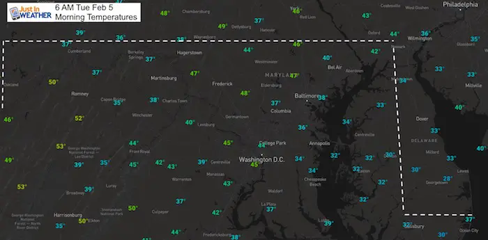
Morning
A signal of the warm up, inland and on the hills its already in the upper 40s. But low to mid 30s around the icy Bay water.
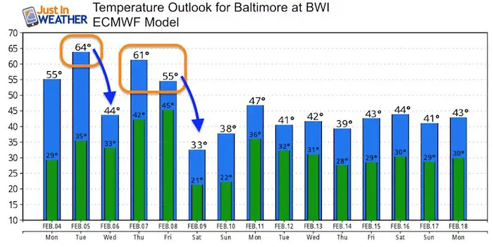
Afternoon High Temperatures
If these verify, they will not be a record

Wednesday

Weather Animation
Rain Wednesday Afternoon Through Friday. After the initial rain, the front should lift to our north, allowing for warmer air to return briefly Thursday and Friday.
Thursday

Friday

Saturday
Colder air returns but the weekend will be dry.

Next Storm:
Snow possible at the start of the next event on Monday
Outlook
After this warm week we should return to near ‘normal’ temperatures for the middle of February.

New Colors
We are giving 10% of each sale to Just In Power Kids: Providing FREE holistic care for pediatric oncology patients.

Please share your thoughts, best weather pics/video, or just keep in touch via social media
-
Facebook: Justin Berk, Meteorologist
-
Twitter: @JustinWeather
-
Instagram: justinweather
FITF and SnowStix

Related Links:
Winter Outlook
My Winter Outlook 2018-19: Multiple Nor’Easters and more snow

Interactive Snow Report
November 15 Snow Reports- Interactive Map Compared To My Forecast

Winter Snow And Top 5 Wet Years
Snowfall Seasons at Beginning and End of Top 5 Wet Years In Baltimore

Related Winter Outlooks
Solar Cycle: When Sun Spots Are Low We Get More Snow
El Nino Modoki May Enhance Snow Chances
Sweet Spot: Hitting 70ºF on Halloween is followed by more winter snow
Will A Wet Summer Bring A Snowy Winter?
NOAA Winter 2018-2019 Outlook Explained: This Actually Supports Snow
Winter Outlook From Two Different Farmers Almanacs
Maryland Winters: Snowfall Maps and Baltimore Snow History
