Saturday February 2 2019
The clipper snow on Friday February snow was small but packed a big punch. When this first surfaced, it was apparent we would have arctic air in place that kept most of the region in the teens to near 20ºF in the afternoon. This was coming after the arctic blast, which meant everything that fell would stick. Only light snow was expected, and it was supposed to last most of the day. I did my best to explain that a little snow would still be a nuisance on roads. But after a week with snow and dangerously cold air, it still seems to catch people off guard.
BWI Snow Report
The forecast for central Maryland was 1 inch or less. So technically, the airport was just over that mark. The season is now almost exactly on target with an average winter.
- 1.1″ = Feb 1
- 10.6″ = Season To Date
- 10.5″ Normal to date
Comparing
I would never make excuses for a snow forecast. But this one behaved close to what was expected. Yes, there were some exceptions and as always I will point them out. The snow reports below highlight the areas that did get more than forecast. You can compare the forecast I posted to what verified. But first lets address some of the messages on social media:
Advisory Maps
If your county did not get a Winter Weather Advisory, talk to your local NWS Office. I am not allowed to post them. I stated on Thursday I felt some areas should be included and prepare for a snow day. This included York and Lancaster in PA. They were finally added from NWS mid afternoon. I did write them to suggest it. Cecil Co in Maryland often gets similar weather to nearby Harford County. But they are zoned under a different NWS Office. Sadly, the lack of coordination between them leads to a lot of confusion.
When I post a map of advisories or warnings, it is the official alert. I can not make my own. All I can do is elaborate or make suggestions.
Keep In Touch Every Day
If you were surprised by the storm, you might not have seen my multiple updates. I would never claim perfection, but I do share new information and try to inform our region as best as possible.
Just in case you don’t get all posts on your social media feed, stay up to date with the latest info…
Click here to sign up for email alerts…. Be the first to hear any new weather.
What went right:
- Snow arrived in the morning between 6 and 8 AM for most of our region.
- Snow lasted most of the day. My forecast online and for my clients was for snow during the daylight hours.
- “A little snow causing big problems”. That was the title of one snow forecast article I posted. I think it was justified.
- Snow stuck quickly and all continued sticking all day.
- York and Lancaster I stated loudly I thought should have been in the Advisory. I made a strong point to expect a snowy day there.
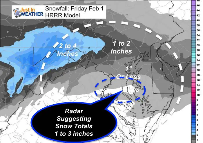
- Most metro snow totals were within 1 inch of the forecast. It did seem like more with the stickage impact. *Some spots did end up between 2 and 3 inches. See the NWS Spotter maps below.
What went wrong:
- Areas that did get snow earlier expected include southern Maryland and the Eastern Shore. These locations should have had an advisory added when it was obvious that snow was impacting them like the rest of us.
- Metro Washington DC and Baltimore: I expected snow to stop by noon, but it lasted longer.
- Central Maryland around the Baltimore beltway I posted will get 1 inch or less. Some spots did end up between 2 and 3 inches. See the NWS Spotter maps below.
- York County PA: I expected 1 to 2 inches and they got between 1 and 3 inches.
- Southern Maryland got snow in the morning. This was a surprise south of Rt 50.
- Central and northern Delmarva had impacting snow in the morning. Kent Island and east was a bust for my morning call. I expected most of this area to see the bus of their snow after noon.
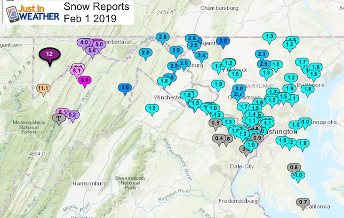
- Western Maryland definitely overachieved! Cumberland got 6″ and Deep Creek Lake got 8 to 12 inches.
Snow Spotter List And Local Maps Below
Forecast Map- I went with the HRRR model and added the radar estimate in the morning for southern Maryland.
NWS Snow Spotter Reports
North of Baltimore was in the 1 to 2 inch range. The reports there mostly fit. Some spots were close to 3 inches. lose view maps are below.
You may have something different where you are located. This is just the collection of their data.
Snow Spotter Reports And Local Maps
NWS Sterling VA (Baltimore/Washington)
********************STORM TOTAL SNOWFALL********************

LOCATION          STORM TOTAL     TIME/DATE   COMMENTS
                     SNOWFALL           OF
                     /INCHES/   MEASUREMENT

DISTRICT OF COLUMBIA

...District of Columbia...
   Somerset 1 SE          1.5   217 PM  2/01  Trained Spotter
   Washington 1 E         1.0   600 PM  2/01  Trained Spotter
   National Zoo 1 WSW     0.8   240 PM  2/01  Trained Spotter


MARYLAND

...Allegany County...
   Ridgeley 1 NW          6.0   251 PM  2/01  Trained Spotter
   Frostburg 2 ENE        5.8   323 PM  2/01  Trained Spotter
   Cresaptown  SSW        5.6   400 PM  2/01  Trained Spotter
   Cumberland             5.0   322 PM  2/01  Co-Op Observer
   Frostburg              4.0   417 PM  2/01  Trained Spotter

...Anne Arundel County...
   Churchton  ENE         1.9   600 PM  2/01  Trained Spotter
   Lothian 4 WSW          1.2   530 PM  2/01  Trained Spotter
   Bwi Airport          1.1   706 PM  2/01  Airport
   Annapolis 1 NW         1.0   600 PM  2/01  Trained Spotter
   Riva 2 WNW             1.0   345 PM  2/01  Trained Spotter

...Baltimore County...
   Dundalk 1 ESE          1.8   613 PM  2/01  Trained Spotter
   Perry Hall 1 NNE       1.8   640 PM  2/01  Trained Spotter
   Long Green 2 NW        1.7   630 PM  2/01  Trained Spotter
   Upper Falls 1 NNE      1.6   715 PM  2/01  Trained Spotter
   White Marsh 2 E        1.5   732 PM  2/01  Trained Spotter
   Bentley Springs 1 E    1.5   620 PM  2/01  Trained Spotter
   Glyndon 1 SW           1.5   524 PM  2/01  Trained Spotter
   Pimlico  SE            1.3   520 PM  2/01  Trained Spotter
   Parkton 1 W            1.2   645 PM  2/01  Trained Spotter


...Baltimore City...
   Arbutus 2 NNE          1.9   745 PM  2/01  Trained Spotter

...Howard County...
   Columbia               2.0 706 PM 2/01     NWS Employee
   Columbia               2 N 1.7 530 PM 2/01 Trained Spotter
   Elkridge               2 W 1.5 620 PM 2/01 Trained Spotter
   Elkridge               1.5 541 PM 2/01     NWS Employee
   Simpsonville           E 1.5 700 PM 2/01   Trained Spotter
   Simpsonville           1 SSE 1.2 300 PM 2/01 Trained Spotter
MARYLAND
...Allegany County...
Ridgeley 1 NW 6.0 251 PM 2/01 Trained Spotter
Frostburg 2 ENE 5.8 323 PM 2/01 Trained Spotter
Cresaptown SSW 5.6 400 PM 2/01 Trained Spotter
Cumberland 5.0 322 PM 2/01 Co-Op Observer
Frostburg 4.0 417 PM 2/01 Trained Spotter
...Anne Arundel County...
Churchton ENE 1.9 600 PM 2/01 Trained Spotter
Lothian 4 WSW 1.2 530 PM 2/01 Trained Spotter
Bwi Airport 1.1 706 PM 2/01 Airport
Annapolis 1 NW 1.0 600 PM 2/01 Trained Spotter
Riva 2 WNW 1.0 345 PM 2/01 Trained Spotter
...Baltimore County...
Dundalk 1 ESE 1.8 613 PM 2/01 Trained Spotter
Perry Hall 1 NNE 1.8 640 PM 2/01 Trained Spotter
Long Green 2 NW 1.7 630 PM 2/01 Trained Spotter
Upper Falls 1 NNE 1.6 715 PM 2/01 Trained Spotter
White Marsh 2 E 1.5 732 PM 2/01 Trained Spotter
Bentley Springs 1 E 1.5 620 PM 2/01 Trained Spotter
Glyndon 1 SW 1.5 524 PM 2/01 Trained Spotter
Pimlico SE 1.3 520 PM 2/01 Trained Spotter
Parkton 1 W 1.2 645 PM 2/01 Trained Spotter
...Baltimore City...
Arbutus 2 NNE 1.9 745 PM 2/01 Trained Spotter
...Howard County...
Columbia 2.0 706 PM 2/01 NWS Employee
Columbia 2 N 1.7 530 PM 2/01 Trained Spotter
Elkridge 2 W 1.5 620 PM 2/01 Trained Spotter
Elkridge 1.5 541 PM 2/01 NWS Employee
Simpsonville E 1.5 700 PM 2/01 Trained Spotter
Simpsonville 1 SSE 1.2 300 PM 2/01 Trained Spotter

...Calvert County...
   Prince Frederick 1 S   1.0   340 PM  2/01  Trained Spotter
   Huntingtown 2 SW       0.8   536 PM  2/01  Trained Spotter

...Carroll County...
   Taneytown              4.0.  600 PM  2/01  Social Media
   Gamber 2 WNW           2.5   555 PM  2/01  Trained Spotter
   Westminster 2 SE       2.3   500 PM  2/01  Trained Spotter
   Eldersburg 1 SE        1.3   520 PM  2/01  Trained Spotter
   Lineboro 3 WSW         1.0   309 PM  2/01  Trained Spotter

... Harford County...
No reports from any spotters in this area. I added a 2 inch report from Bel Air on the map.


New Partner
Buchanan Kia of Westminster is a supporter of Just In Power Kids and Maryland Trek 6 in August 2019.
...Frederick County... Walkersville 1 E 3.0 525 PM 2/01 Trained Spotter Thurmont 3 N 3.0 440 PM 2/01 NWS Employee Adamstown 1 ESE 1.9 503 PM 2/01 Trained Spotter Bloomfield 2 WSW 1.7 315 PM 2/01 NWS Employee New Market N 1.5 625 PM 2/01 Trained Spotter Walkersville ESE 1.2 225 PM 2/01 Trained Spotter ...Washington County... Long Meadow 1 SSE 3.5 353 PM 2/01 Trained Spotter Pecktonville 3 NNW 2.8 220 PM 2/01 NWS Employee Long Meadow 2 W 2.6 230 PM 2/01 CoCoRaHS Hagerstown 1 SW 2.5 400 PM 2/01 Trained Spotter Boonsboro 3 NNE 2.4 600 PM 2/01 Trained SpotterGarrett County A Range of 8 to 12 inches report. SnowStix photos confirmed these amounts.
...Montgomery County... Clarksburg 2 SE 2.6 529 PM 2/01 Trained Spotter Damascus 3 SSW 2.0 456 PM 2/01 Co-Op Observer Wheaton 1 ESE 1.9 455 PM 2/01 Trained Spotter Rockville 3 NNW 1.7 625 PM 2/01 NWS Employee Ashton ENE 1.6 515 PM 2/01 Trained Spotter Bethesda 1 NNW 1.5 625 PM 2/01 Trained Spotter Norbeck 1 ESE 1.5 530 PM 2/01 Trained Spotter Garrett Park 1 N 1.4 405 PM 2/01 Trained Spotter Chevy Chase 1 W 1.1 545 PM 2/01 Trained Spotter ...Prince Georges County... College Park 1 ENE 1.3 500 PM 2/01 Trained Spotter University Park 1 E 1.1 214 PM 2/01 NWS Office College Park 2 SSE 1.1 214 PM 2/01 NWS Employee Upper Marlboro 1 NNW 1.0 514 PM 2/01 Trained Spotter ...St Marys County... California 2 W 0.7 250 PM 2/01 Trained Spotter Eastern Shore ...Caroline County... Denton 2.3 in 0208 PM 02/01 Emergency Mngr ...Cecil County... 1 SSE Pleasant Hill 1.5 in 0833 PM 02/01 Cocorahs Fair Hill 1.1 in 0808 PM 02/01 Public ...Kent County... Millington 2.9 in 0831 PM 02/01 Trained Spotter ...Queen Annes County... 4 SW Chester 1.0 in 0309 PM 02/01 Public ...Talbot County... Royal Oak 2.0 in 0155 PM 02/01 CO-OP Observer
Southern Pennsylvania:
Some of these spotter locations might be old.

York County 1 to 3 inches
Shrewsbury  3.0. 600 PM 2/01 Social Media
Love Snow and Love Maryland Sale
It’s less than 15 days until Valentine’s Day
Any Love Snow or Love Maryland item is 15% Off until Sunday.
Use promo code: LOVESNOW15
The first 15 orders get our new FITF bag. Orders after that get another surprise gift.

VIRGINIA

...Alexandria County...
   Franconia 1 SSW        0.8   445 PM  2/01  Trained Spotter

...Arlington County...
   Ballston 1 SSW         1.5   411 PM  2/01  Trained Spotter
   Ballston 1 SW          1.5   411 PM  2/01  Trained Spotter
   Rosslyn 1 S            1.3   315 PM  2/01  Trained Spotter
   Barcroft 2 E           1.2   200 PM  2/01  Trained Spotter
   Arlington              1.2   453 PM  2/01  Trained Spotter
   Reagan National Apt    0.9   657 PM  2/01  Airport

...Fairfax County...
   Herndon 2 ENE          1.3   300 PM  2/01  Trained Spotter
   Tysons Corner 1 N      1.2   210 PM  2/01  NWS Employee
   Vienna 1 WNW           1.0   305 PM  2/01  Trained Spotter
   Rose Hill  ENE         1.0   315 PM  2/01  Trained Spotter
   Chantilly 3 SE         0.6   400 PM  2/01  Trained Spotter
   Centreville  W         0.4   340 PM  2/01  Trained Spotter

...Falls Church County...
   Falls Church 1 W       1.3   400 PM  2/01  Trained Spotter

...Frederick County...
   Stephens City 2 E      1.5   225 PM  2/01  Trained Spotter

...Loudoun County...
   Purcellville 1 SW      2.0   515 PM  2/01  Trained Spotter
   Purcellville           1.5   827 PM  2/01  NWS Employee
   Hillsboro 3 NW         1.5   416 PM  2/01  Trained Spotter
   Leesburg 1 N           1.3   515 PM  2/01  Trained Spotter
   Ashburn                1.2   312 PM  2/01  NWS Employee
   Leesburg 2 WNW         1.1   844 PM  2/01  NWS Employee
   Leesburg 2 E           1.0   300 PM  2/01  Trained Spotter
   Dulles International   0.9   647 PM  2/01  Airport

WEST VIRGINIA

...Berkeley County...
   Martinsburg 2 E        2.5   405 PM  2/01  NWS Employee
   Falling Waters 2 NW    2.5   432 PM  2/01  Trained Spotter
   Vanville 1 SSW         2.0   544 PM  2/01  Trained Spotter
   Shepherdstown 4 NNW    2.0   720 PM  2/01  Trained Spotter
   Bunker Hill  SE        1.8   300 PM  2/01  Trained Spotter

...Grant County...
   Bayard                11.1   215 PM  2/01  Co-Op Observer
   Kline Gap 2 ESE        8.1   400 PM  2/01  Trained Spotter
   Cabins 1 NNE             T   611 PM  2/01  Trained Spotter

...Hampshire County...
   Capon Bridge 3 WSW     3.0   515 PM  2/01  Trained Spotter

...Hardy County...
   Rig  NNW               5.2   500 PM  2/01  Trained Spotter

...Jefferson County...
   Bloomery 3 SSE         1.6   450 PM  2/01  Trained Spotter

...Mineral County...
   Keyser                 9.0   550 PM  2/01  Trained Spotter
   Keyser 2 SSW           8.1   209 PM  2/01  Co-Op Observer
   Burlington  E          6.6   515 PM  2/01  Trained Spotter

...Morgan County...
   Smith Crossroads 1 W   2.8   337 PM  2/01  Trained Spotter
Snowstix- We Need You To Measure Snow Too
We are giving 10% of each sale to Just In Power Kids: Providing FREE holistic care for pediatric oncology patients.

Please share your thoughts, best weather pics/video, or just keep in touch via social media
-
Facebook: Justin Berk, Meteorologist
-
Twitter: @JustinWeather
-
Instagram: justinweather
Related Links:
Winter Outlook
My Winter Outlook 2018-19: Multiple Nor’Easters and more snow

Interactive Snow Report
November 15 Snow Reports- Interactive Map Compared To My Forecast

Winter Snow And Top 5 Wet Years
Snowfall Seasons at Beginning and End of Top 5 Wet Years In Baltimore

Related Winter Outlooks
Solar Cycle: When Sun Spots Are Low We Get More Snow
El Nino Modoki May Enhance Snow Chances
Sweet Spot: Hitting 70ºF on Halloween is followed by more winter snow
Will A Wet Summer Bring A Snowy Winter?
NOAA Winter 2018-2019 Outlook Explained: This Actually Supports Snow
Winter Outlook From Two Different Farmers Almanacs
Maryland Winters: Snowfall Maps and Baltimore Snow History
