Friday February 1 2019
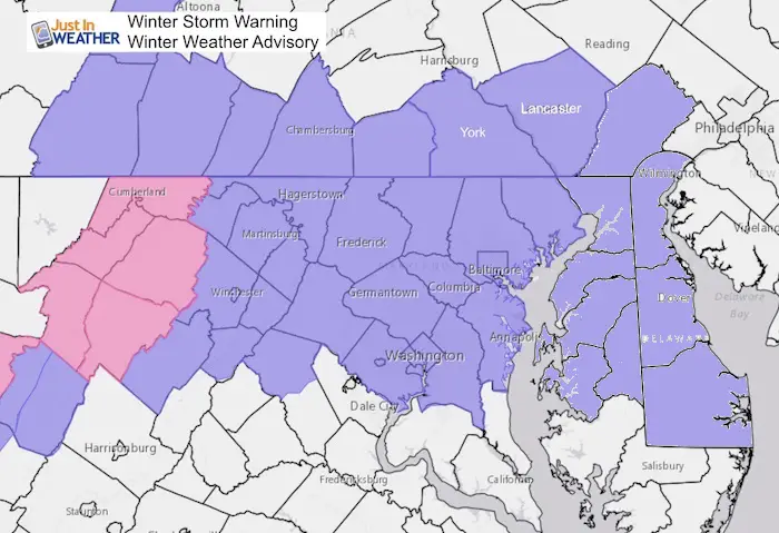
The clipper today arrived on schedule and in the deep freeze. So its most of the are in the teens, all that fell was able to stick. There were some locations where the snow overachieved but dumping more or arriving early. The adjustment for the mountains is why a Winter Storm Warning was upgraded. This included Garrett And Allegheny Counties in Maryland where snow ranged from 6 to 12 inches.
The best photo was from Kevin Cuozzo at Deep Creek Lake. They got 12 inches of snow, and I think his grill was smiling.

Winter Weather Advisory Update:
- NWS State College FINALLY added York and Lancaster at 2:30 until 5 PM
- Central Maryland extended to 5 PM
- Cecil Co and MD Eastern Shore, your NWS Office finally added you as well until 7 PM
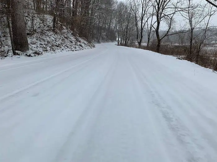
Snowy Roads
Even a dusting to 2 inches can cause bog problems when it all sticks. This photo was from along the Maryland and PA (York Co) region
Love Snow and Love Maryland Sale
It’s less than 15 days until Valentine’s Day
Any Love Snow or Love Maryland item is 15% Off until Sunday.
Use promo code: LOVESNOW15
The first 15 orders get our new FITF bag. Orders after that get another surprise gift.

Keep In Touch Every Day
Just in case you don’t get all posts on your social media feed, stay up to date with the latest info…
Click here to sign up for email alerts…. Be the first to hear any new weather.
Locally the overachieving snow was it arriving earlier on Maryland’s Eastern Shore and southern Maryland. Not all snow reports are listed here, but this is the best I could gather as of 1 PM Friday. Note: Compare the forecast map to the totals so far.
Snow Reports:
Map form NWS Sterling VA Region. I added a few other reports. See the list below. First compare to the forecast map I was showing.

Forecast from my last report. Most metro areas were expecting 1 inch or less. Up to 2 inches in the northern zones.

Snow Reports From NWS LWX (Baltimore/Washington)
********************STORM TOTAL SNOWFALL********************

LOCATION          STORM TOTAL     TIME/DATE   COMMENTS
                     SNOWFALL           OF
                     /INCHES/   MEASUREMENT

DISTRICT OF COLUMBIA

...District of Columbia...
   National Zoo 1 WSW     0.4   945 AM  2/01  Trained Spotter

MARYLAND

...Allegany County...
   Frostburg              6.5   108 PM  2/01  Trained Spotter
   Mount Savage           5.0  1238 PM  2/01  Trained Spotter
   Ridgeley 1 NW          4.3  1122 AM  2/01  Trained Spotter
   Cresaptown  SSW        3.1  1000 AM  2/01  Trained Spotter

...Anne Arundel County...
   Bwi Airport            0.8   100 PM  2/01  Airport
   Cape St. Claire 1 SS   0.4  1100 AM  2/01  Trained Spotter

...Baltimore County...
   Bentley Springs 1 E    0.5  1230 PM  2/01  Trained Spotter
   Glyndon 1 SW           0.5  1208 PM  2/01  Trained Spotter
   Reisterstown           0.3  1012 AM  2/01  County Emrg Mgmt

...Calvert County...
   Huntingtown 2 WNW      0.7  1230 PM  2/01  Trained Spotter
   Dunkirk 2 SSW          0.5  1201 PM  2/01  Trained Spotter

...Carroll County...
   Eldersburg 1 SE        1.5  1150 AM  2/01  Trained Spotter

...Charles County...
   La Plata                 T  1021 AM  2/01  Trained Spotter

...Frederick County...
   Ballenger Creek 2 NW   0.6  1203 PM  2/01  Trained Spotter
   Adamstown 1 ESE        0.5  1100 AM  2/01  Trained Spotter

...Harford County...
   Fallston 1 NW          0.5  1221 PM  2/01  Trained Spotter

...Howard County...
   Simpsonville 1 SSE     0.9  1215 PM  2/01  Trained Spotter
   Savage 1 N             0.7  1130 AM  2/01  Trained Spotter
   Columbia 2 N           0.7  1120 AM  2/01  Trained Spotter
   Elkridge 2 W             T   814 AM  2/01  Trained Spotter

...Montgomery County...
   Bethesda               1.5  1239 PM  2/01  County Emrg Mgmt
   White Oak 1 W          1.3  1200 PM  2/01  Trained Spotter
   Norbeck 1 ESE          1.2  1254 PM  2/01  Trained Spotter
   Germantown 1 NE        1.1  1152 AM  2/01  NWS Employee
   Gaithersburg           1.0  1111 AM  2/01  County Emrg Mgmt
   Washington Grove 1 N   1.0  1052 AM  2/01  Trained Spotter
   Rockville              0.8  1052 AM  2/01  County Emrg Mgmt
   Clarksburg             0.5   942 AM  2/01  County Emrg Mgmt
   Gaithersburg 3 SE      0.5   943 AM  2/01  County Emrg Mgmt
   Germantown             0.3   925 AM  2/01  County Emrg Mgmt

...Prince Georges County...
   Upper Marlboro 1 NNW   0.8  1247 PM  2/01  Trained Spotter
   University Park 1 E    0.6   950 AM  2/01  NWS Office

...Washington County...
   Boonsboro 3 NNE        0.9  1245 PM  2/01  Trained Spotter
   Hagerstown 2 NE        0.5  1204 PM  2/01  Trained Spotter

VIRGINIA

...Alexandria County...
   Franconia 1 SSW        0.6  1245 PM  2/01  Trained Spotter

...Arlington County...
   Ballston 1 SW          1.2  1100 AM  2/01  Trained Spotter
   Baileys Crossroads 1   1.2  1130 AM  2/01  Trained Spotter
   Arlington              1.0  1151 AM  2/01  Trained Spotter
   Reagan National Apt    0.8   100 PM  2/01  Airport
   Reagan National Airp   0.7  1130 AM  2/01  Trained Spotter
   Baileys Xrds           0.1   830 AM  2/01  CoCoRaHS

...Clarke County...
   Berryville 1 NNW       1.1  1240 PM  2/01  Trained Spotter

...Fairfax County...
   The I66 And I495 1 S   1.0  1132 AM  2/01  Trained Spotter
   Vienna                 1.0  1239 PM  2/01  Co-Op Observer
   Herndon 1 NNE          0.5  1015 AM  2/01  NWS Employee
   Centreville  W         0.4  1155 AM  2/01  Trained Spotter

...Frederick County...
   Winchester             1.3  1200 PM  2/01  Trained Spotter

...Loudoun County...
   Purcellville 1 SW      1.3  1221 PM  2/01  Trained Spotter
   Leesburg 1 N           1.1  1250 PM  2/01  Trained Spotter
   Purcellville           1.0  1138 AM  2/01  NWS Employee
   Arcola 1 NNE           1.0  1139 AM  2/01  Trained Spotter
   Alexandria 1 W         1.0  1245 PM  2/01  Trained Spotter
   Hughesville 1 ESE      1.0  1245 PM  2/01  Trained Spotter
   Dulles International   0.8   100 PM  2/01  Airport
   Ashburn 3 WSW          0.5   950 AM  2/01  NWS Employee

...Prince William County...
   Woolsey 1 SW           0.1  1150 AM  2/01  Trained Spotter

WEST VIRGINIA

...Berkeley County...
   Martinsburg 2 E        1.4   109 PM  2/01  NWS Employee
   Bunker Hill  SE        1.0  1200 PM  2/01  Trained Spotter

...Grant County...
   Kline Gap 2 ESE        7.5  1145 AM  2/01  Trained Spotter
   Petersburg             5.0  1056 AM  2/01  Co-Op Observer
   Cabins 1 NNE           3.5   835 AM  2/01  Trained Spotter

...Hampshire County...
   Points 2 NNW           1.5   826 AM  2/01  Trained Spotter

...Hardy County...
   Moorefield 1 N         4.0  1135 AM  2/01  Trained Spotter
   Moorefield             2.0   851 AM  2/01  Trained Spotter
   Moorefield 3 ENE       1.9   854 AM  2/01  Trained Spotter
   Wardensville 3 E       1.5  1110 AM  2/01  Trained Spotter
   Moorefield 3 SSE       1.4   830 AM  2/01  CoCoRaHS
   Moorefield 4 SSE       1.4   830 AM  2/01  Trained Spotter

...Mineral County...
   Burlington  E          6.2  1215 PM  2/01  Trained Spotter
   Keyser                 4.5   911 AM  2/01  Trained Spotter

...Morgan County...
   Paw Paw                2.0  1115 AM  2/01  Trained Spotter

...Pendleton County...
   Upper Tract 1 N        4.0  1142 AM  2/01  Trained Spotter
Afternoon Snow
Afternoon—> slider
[metaslider id=72451]
Evening Temperatures


New Partner
Buchanan Kia of Westminster is a supporter of Just In Power Kids and Maryland Trek 6 in August 2019.
Please share your thoughts, best weather pics/video, or just keep in touch via social media
-
Facebook: Justin Berk, Meteorologist
-
Twitter: @JustinWeather
-
Instagram: justinweather
Related Links:
Winter Outlook
My Winter Outlook 2018-19: Multiple Nor’Easters and more snow

Interactive Snow Report
November 15 Snow Reports- Interactive Map Compared To My Forecast

Winter Snow And Top 5 Wet Years
Snowfall Seasons at Beginning and End of Top 5 Wet Years In Baltimore

Related Winter Outlooks
Solar Cycle: When Sun Spots Are Low We Get More Snow
El Nino Modoki May Enhance Snow Chances
Sweet Spot: Hitting 70ºF on Halloween is followed by more winter snow
Will A Wet Summer Bring A Snowy Winter?
NOAA Winter 2018-2019 Outlook Explained: This Actually Supports Snow
Winter Outlook From Two Different Farmers Almanacs
Maryland Winters: Snowfall Maps and Baltimore Snow History
