Saturday January 26 2019
The weather this weekend will be quiet for most of our region, but there will be a lot of extra noise on the Chesapeake Bay for the Polar Bear Plunge. Below is a look at the hourly temperatures for the event today. It’s a cold start, but will be a seasonable afternoon. The big story will be the Polar Vortex across the Northern US and the extreme the reaches us. It is becoming more obvious that it will arrive with some snow and icy roads. More on that below.
Temperature Timeline for MD Polar Bear Plunge
Bay Water Temps measured 38ºF this morning at nearby Thomas Pt Lighthouse
[metaslider id=71883]
Local Weather Stats For January 26, 2019 in Baltimore
Average High: 42ºF
Record High: 79ºF in 1950
Average Low: 24ºF
Record Low: 2ºF in 1961
*Record Snow: 7.6* in 2011
Sunrise: 7:18 AM
Sunset 5:19 PM
*Daylight = 1:53 longer than yesterday
*Bay Water Temperature = 38ºF at Thomas Pt. Light House

New Partner
Buchanan Kia of Westminster is a supporter of Just In Power Kids and Maryland Trek 6 in August 2019.
Keep In Touch Every Day
Just in case you don’t get all posts on your social media feed, stay up to date with the latest info…
Click here to sign up for email alerts…. Be the first to hear any new weather.
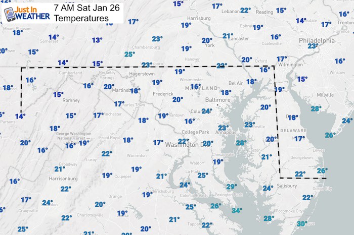
Morning Set Up
Temperatures
Baltimore at 7 AM
- Temperature = 19ºF
- Wind Gusts: Calm
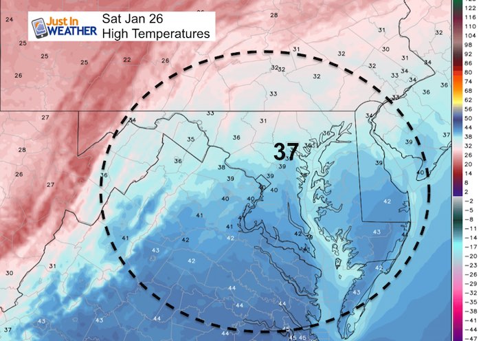
Noon
A disturbance is most likely to just provide passing clouds. But there could be a few flurries, especially in the mountains

High Temperatures
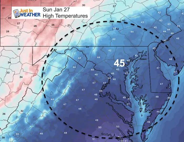
Sunday:
Snow showers over the western mountains bring them a fresh coasting for Sunday morning. This disturbance will move east and fade over the mountains. However there could be some flurries west of the front ridge.


High Temperatures
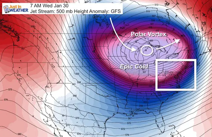
Skipping Ahead:
The core of the coldest air will pass to our north Tuesday and Wednesday, and drag a cold front our way.
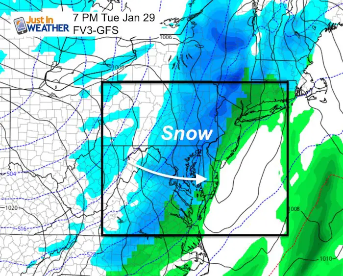
Tuesday Evening
Rain showers will chancer to a burst of snow for a few hours. This is the kind of set up that better supports a Flash Freeze than what we had last week. The reason is that there will be a damp ground and snow falling on top as the temps tank.
Snow Timeline (European Model) –> slider
Snow totals: It’s too early to confirm, but this pattern supports a dusting to 2 inches.
[metaslider id=71866]
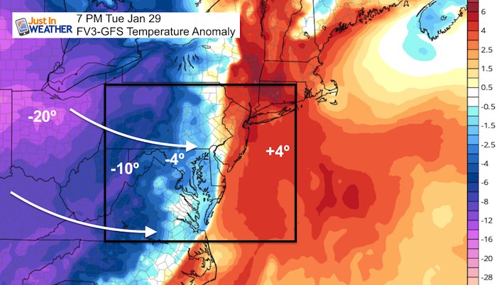
FV3-GFS
Temperatures Tank Tuesday Night
This map shows temperatures relative to ‘normal’. The core of the cold air will be close to 20 degrees below normal in Ohio.
SnowStix
We have added a bunch of new color options

We are giving 10% of each sale to Just In Power Kids: Providing FREE holistic care for pediatric oncology patients.
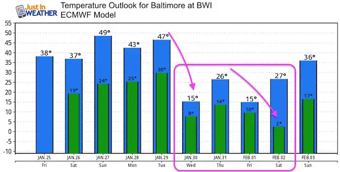
Temperature Outlook
Keep In Touch Every Day
Just in case you don’t get all posts on your social media feed, stay up to date with the latest info…
Click here to sign up for email alerts…. Be the first to hear any new weather.
Please share your thoughts, best weather pics/video, or just keep in touch via social media
-
Facebook: Justin Berk, Meteorologist
-
Twitter: @JustinWeather
-
Instagram: justinweather
FITF and SnowStix

Related Links:
Winter Outlook
My Winter Outlook 2018-19: Multiple Nor’Easters and more snow

Interactive Snow Report
November 15 Snow Reports- Interactive Map Compared To My Forecast

Winter Snow And Top 5 Wet Years
Snowfall Seasons at Beginning and End of Top 5 Wet Years In Baltimore

Related Winter Outlooks
Solar Cycle: When Sun Spots Are Low We Get More Snow
El Nino Modoki May Enhance Snow Chances
Sweet Spot: Hitting 70ºF on Halloween is followed by more winter snow
Will A Wet Summer Bring A Snowy Winter?
NOAA Winter 2018-2019 Outlook Explained: This Actually Supports Snow
Winter Outlook From Two Different Farmers Almanacs
Maryland Winters: Snowfall Maps and Baltimore Snow History
