Friday January 25 2019
You may have noticed the colder winds today, but that is nothing compared to what is on the way next week. The weather pattern has the hallmarks of epic cold that will challenge records for a few days. We have had intense cold air quite a few times over the past four years, and many were associated with the Polar Vortex. This is simply a fact of a weather pattern that sometimes takes the core cold form the North Pole and drives it due southern across Canada into the northern US. This will happen early next week.
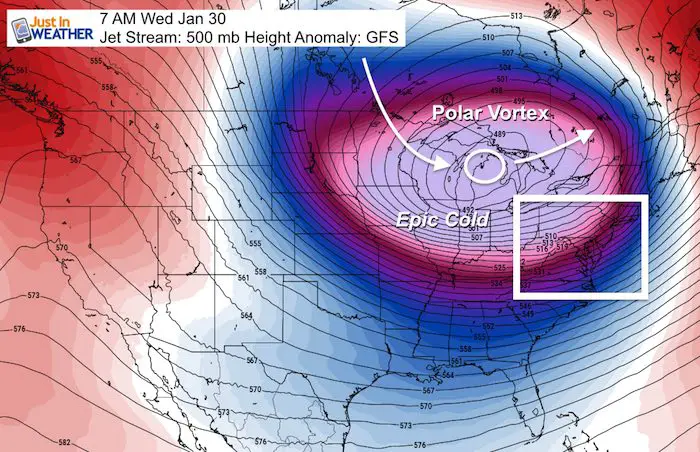
Here’s a look at the upper air circulation next Wednesday morning. I’ve highlighted the forecast track, which keeps it north of our region, and keeps the coldest of the air to our north. But we will get in on the action and it should come with a burst of snow to lay down the white carpet.
Polar Vortex
Snow Burst Ahead Of Arctic Air
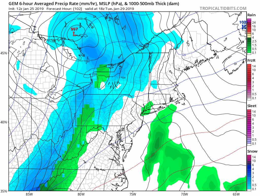
This is a quick post skipping the weekend weather and just focusing on the chance of snow ahead of the arctic cold blast. Here is a look at how the European Model sees the arrival of the arctic air. The update here is that a wave of Low Pressure may form along the front, which will enhance the moisture along it. This is seen for our region Tuesday night and Wednesday morning.
Snow Timeline –> slider
Snow totals: It’s too early to confirm, but this pattern supports a dusting to 2 inches.
[metaslider id=71866]
Canadian GEM Animation
This model agrees with the notion of enhance snow along the arctic front. If only for a few hours, enough for minor accumulation.
Will We See Record Cold?
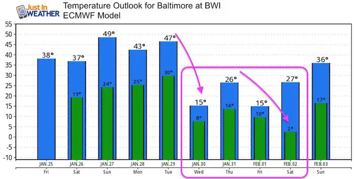
Temperature Outlooks
Let’s first take a look at some climate date for Baltimore at BWI for next week:
January 30 (Wed):
42ºF = Normal High; 25ºF = Normal Low
16ºF in 1966 = Record Cold Max Temperature *(Chance to break this)
-4ºF in 1873 = Record Min Temperature *(Chance to break this)
January 31 (Thur):
42ºF = Normal High; 25ºF = Normal Low
22ºF in 1948 = Record Cold Max Temperature *(Chance to break this)
+4ºF in 1966 = Record Min Temperature *(Chance to break this)
February 1 (Fri):
42ºF = Normal High; 25ºF = Normal Low
18ºF in 1971 = Record Cold Max Temperature
+7ºF in 1965 = Record Min Temperature *(Chance to break this)
February 2 (Sat):
42ºF = Normal High; 25ºF = Normal Low
17ºF in 1881 = Record Cold Max Temperature
+1ºF in 1961 = Record Min Temperature *(Chance to break this)
Temperature Forecast Outlook
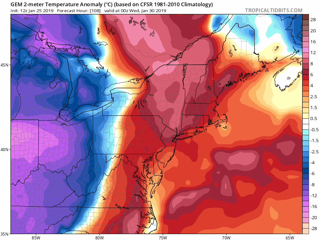
Temperature Anomaly
The purple colors that show up Friday morning mean we will have temperers 16 to 20 degrees (F) below normal. That is what takes climatological low temperature in the mid 20s (for Baltimore) down to the mid to lower single digits at best.
Notes:
The latest modeling supports:
- Some snow with the arctic front. Some accumulation and icy conditions likely Wednesday morning.
- Cold air may get reinforcement and hang around for three to four days.
There is time to track and adjust this timing. There is also time to lock in on how much snow may fall. The main purpose is that this will be an abrupt change and likely to be here by the middle next week.
Lots of fun to follow leading up to this.
SnowStix
We have added a bunch of new color options

We are giving 10% of each sale to Just In Power Kids: Providing FREE holistic care for pediatric oncology patients.
Keep In Touch Every Day
Just in case you don’t get all posts on your social media feed, stay up to date with the latest info…
Click here to sign up for email alerts…. Be the first to hear any new weather.
Please share your thoughts, best weather pics/video, or just keep in touch via social media
-
Facebook: Justin Berk, Meteorologist
-
Twitter: @JustinWeather
-
Instagram: justinweather
FITF and SnowStix

Related Links:
Winter Outlook
My Winter Outlook 2018-19: Multiple Nor’Easters and more snow

Interactive Snow Report
November 15 Snow Reports- Interactive Map Compared To My Forecast

Winter Snow And Top 5 Wet Years
Snowfall Seasons at Beginning and End of Top 5 Wet Years In Baltimore

Related Winter Outlooks
Solar Cycle: When Sun Spots Are Low We Get More Snow
El Nino Modoki May Enhance Snow Chances
Sweet Spot: Hitting 70ºF on Halloween is followed by more winter snow
Will A Wet Summer Bring A Snowy Winter?
NOAA Winter 2018-2019 Outlook Explained: This Actually Supports Snow
Winter Outlook From Two Different Farmers Almanacs
Maryland Winters: Snowfall Maps and Baltimore Snow History


New Partner
Buchanan Kia of Westminster is a supporter of Just In Power Kids and Maryland Trek 6 in August 2019.