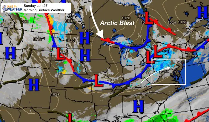
Sunday January 27 2019
Today brings a little warm up ahead of some showers. Snow this morning in the mountains will fade as it moves east, but could redevelop some rain showers in metro areas this afternoon. The main story is the part of the Polar Vortex diving south and it will impact us beginning Tuesday. That is when the arctic front arrives with snow and temps tank. Wednesday morning may be icy with light snow cover, but the coldest of the air will be with us Thursday morning.
Local Weather Stats For January 26, 2019 in Baltimore
Average High: 42ºF
Record High: 72ºF in 1974
Average Low: 25ºF
Record Low: 3ºF in 1987
*Record Snow: 4.3″ in 1925
Sunrise: 7:17 AM
Sunset 5:20 PM
*Daylight = 1:55 longer than yesterday
*Bay Water Temperature = 37ºF at Thomas Pt. Light House

New Partner
Buchanan Kia of Westminster is a supporter of Just In Power Kids and Maryland Trek 6 in August 2019.
Keep In Touch Every Day
Just in case you don’t get all posts on your social media feed, stay up to date with the latest info…
Click here to sign up for email alerts…. Be the first to hear any new weather.
Morning Set Up
Temperatures
Baltimore at 7 AM
- Temperature = 26ºF
- Wind Gusts: Calm

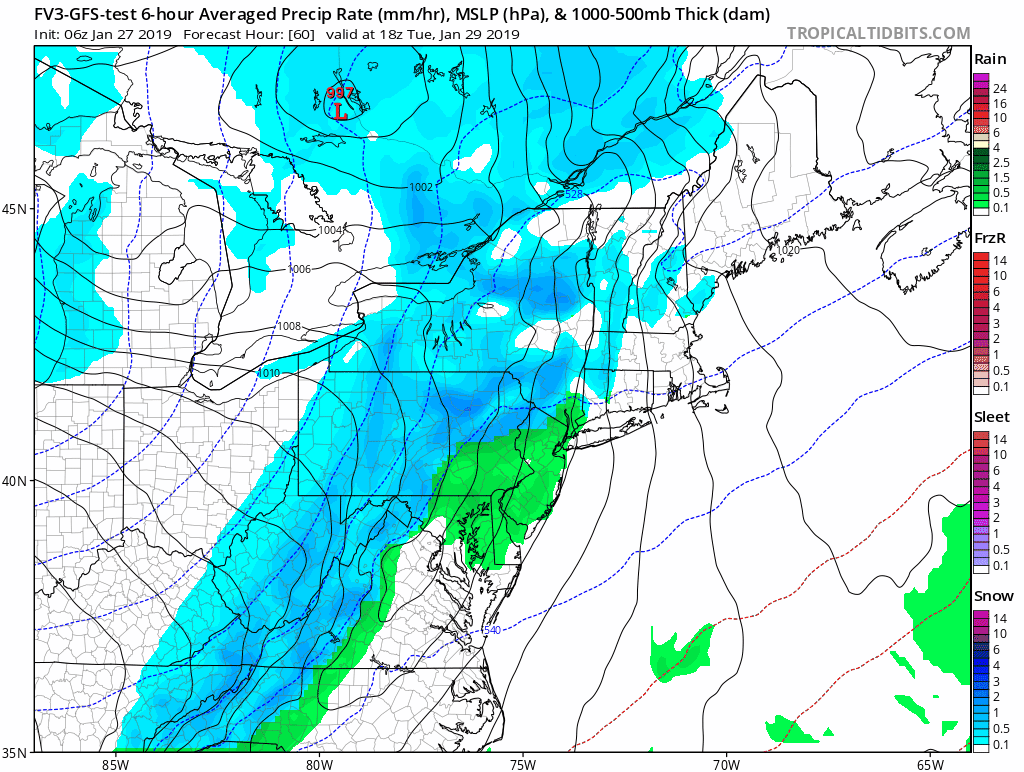
Snow and Rain Timeline —> slider
[metaslider id=71915]
Afternoon Highs

The Arctic Front
The timing appears to be Tuesday evening. We could get some rain showers only to quickly turn to a snow burst that will last a few hours. This will spark legitimate Flash Freeze conditions. Anything wet will freeze as temps tank in a hurry while it is still snowing.

Temperatures
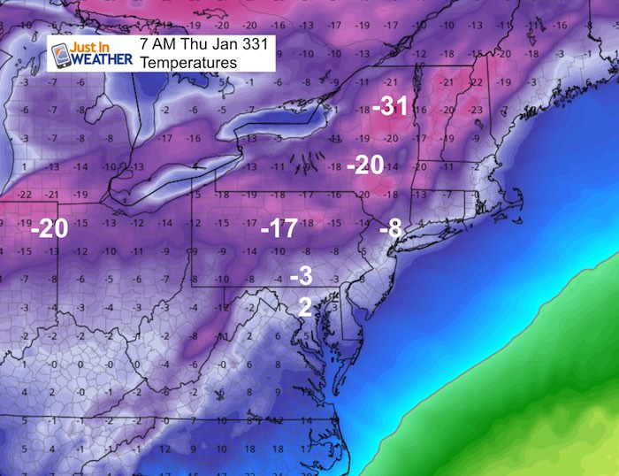
It will be very cold after the front passes, and I expect many roads will be icy even though we only get 1 to 2 inches of snow. It will colder Thursday morning.
Wednesday Morning

Thursday Morning

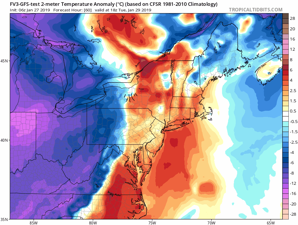
Wider View
Temperatures Transition
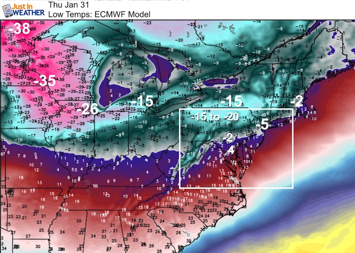
This animation shows temperature anomaly (compared to normal). We will be 15 to 20 degree below normal by Thursday morning.
Snapshots
Low Temperatures- FV3- GFS Model
Low Temperatures- ECMWF Model
SnowStix
We have added a bunch of new color options

We are giving 10% of each sale to Just In Power Kids: Providing FREE holistic care for pediatric oncology patients.
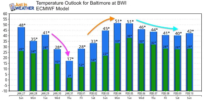
Temperature Outlook
The arctic blast will not last very long. A big warm up swing our way by Monday February 4
Keep In Touch Every Day
Just in case you don’t get all posts on your social media feed, stay up to date with the latest info…
Click here to sign up for email alerts…. Be the first to hear any new weather.
Please share your thoughts, best weather pics/video, or just keep in touch via social media
-
Facebook: Justin Berk, Meteorologist
-
Twitter: @JustinWeather
-
Instagram: justinweather
FITF and SnowStix

Related Links:
Winter Outlook
My Winter Outlook 2018-19: Multiple Nor’Easters and more snow

Interactive Snow Report
November 15 Snow Reports- Interactive Map Compared To My Forecast

Winter Snow And Top 5 Wet Years
Snowfall Seasons at Beginning and End of Top 5 Wet Years In Baltimore

Related Winter Outlooks
Solar Cycle: When Sun Spots Are Low We Get More Snow
El Nino Modoki May Enhance Snow Chances
Sweet Spot: Hitting 70ºF on Halloween is followed by more winter snow
Will A Wet Summer Bring A Snowy Winter?
NOAA Winter 2018-2019 Outlook Explained: This Actually Supports Snow
Winter Outlook From Two Different Farmers Almanacs
Maryland Winters: Snowfall Maps and Baltimore Snow History
