Wednesday January 23 2019
The storm in the way in has a tremendous amount of energy with it. The severe storm threat along the Gulf Coast is riding a fast jet stream our way. The one good thing is that this will arrive for us around sunrise, which is usually the coolest time of the day. That may dampen the impact but we will be on the warm side of this system. A squall line will develop overnight and move though our area with very gust winds and possible thunder.
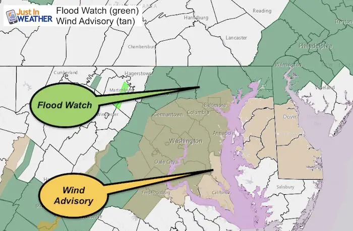
The Wind Advisory is for winds gusting to 50 mph. The latest forecast suggests that is very likely for a large area. See the timeline and more notes below.
The Flood Watch is for rain that could reach between 1 and 2 inches overnight and into Thursday.
This map now includes Delaware and Maryland Eastern Shore counties under the Wind Advisory
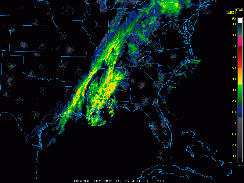
Afternoon Radar Loop

New Partner
Buchanan Kia of Westminster is a supporter of Just In Power Kids and Maryland Trek 6 in August 2019.
Keep In Touch Every Day
Just in case you don’t get all posts on your social media feed, stay up to date with the latest info…
Click here to sign up for email alerts…. Be the first to hear any new weather.
Overnight Rain
Radar Simulation Thursday Morning —> slider
The timing of the squall line will be during the morning commute. This will be the most intense rain, wind, and perhaps some lightning and thunder. The winds will ease briefly behind the front.
[metaslider id=71733]
Rain Potential

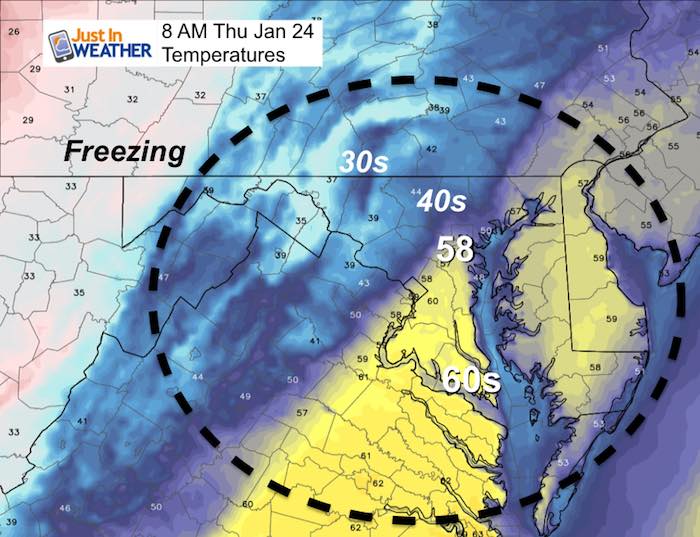
Temperatures At The Squall Line
From the upper 50s to the 40s and 30s behind it
Wind Gust Timeline –> slider
Nice the strongest winds on Delmarva and on the beaches. Gusts there could reach 60 mph. Many areas will be in with reach of 50 mph gusts. This will come from the south. The winds will ease briefly behind the front.
[metaslider id=71752]
SnowStix
We have added a bunch of new color options

We are giving 10% of each sale to Just In Power Kids: Providing FREE holistic care for pediatric oncology patients.
Please share your thoughts, best weather pics/video, or just keep in touch via social media
-
Facebook: Justin Berk, Meteorologist
-
Twitter: @JustinWeather
-
Instagram: justinweather
FITF and SnowStix

Related Links:
Winter Outlook
My Winter Outlook 2018-19: Multiple Nor’Easters and more snow

Interactive Snow Report
November 15 Snow Reports- Interactive Map Compared To My Forecast

Winter Snow And Top 5 Wet Years
Snowfall Seasons at Beginning and End of Top 5 Wet Years In Baltimore

Related Winter Outlooks
Solar Cycle: When Sun Spots Are Low We Get More Snow
El Nino Modoki May Enhance Snow Chances
Sweet Spot: Hitting 70ºF on Halloween is followed by more winter snow
Will A Wet Summer Bring A Snowy Winter?
NOAA Winter 2018-2019 Outlook Explained: This Actually Supports Snow
Winter Outlook From Two Different Farmers Almanacs
Maryland Winters: Snowfall Maps and Baltimore Snow History
