Thursday January 17 2019
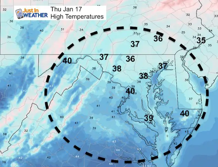
Today will be dry with some thing in the afternoon, but snow will arrive late afternoon and evening on the north side. So if you have activities, not all will be impacted at first. But a round of snow or mix will spread overnight, then gone before sunrise. This will be a minor event, but there will be some areas that remain icy Friday morning, while many metro area will that.
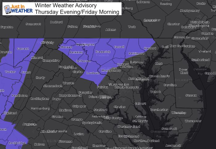
This Winter Weather Advisory has been issued for the counties west and north of Baltimore and Washington, where the impact is likely to remain for the morning commute. Southern PA has not had their local NWS office issue an advisory yet, but considers yourself to be included.
Below is a look at two snow timelines to show the first round later afternoon and the overnight push of snow. Also a look at snow potential, which will be generally an inch or two in the affected areas.
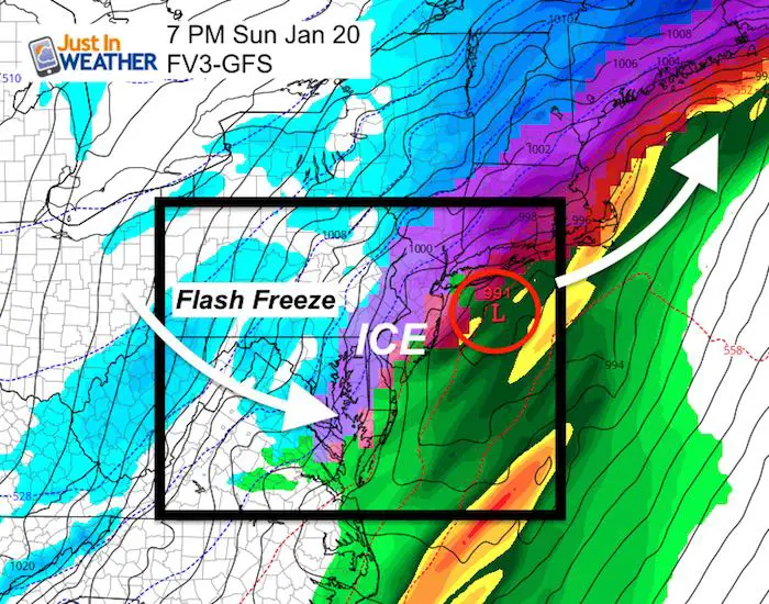
The weekend event will be bigger, and as I wrote yesterday… Snow Saturday evening will change to rain, but northern areas could remain icy. Then the return to snow Sunday will come with arctic air. The snow totals are not as important as the flash freeze. Quick icing for many areas expected Sunday afternoon.
Local Weather Stats For January 17, 2019 in Baltimore
*Second day of Record Heat Wave for January*
Average High: 41ºF
Record High: 68ºF in 1913
Average Low: 24ºF
Record Low: -7ºF in 1982 *Coldest on record
*Record Snow: 2.5 in 1985
Sunrise: 7:23 AM
Sunset 5:09 PM
*Daylight = 1:30 longer than yesterday
*Bay Water Temperature = 37ºF at Thomas Pt. Light House

New Partner
Buchanan Kia of Westminster is a supporter of Just In Power Kids and Maryland Trek 6 in August 2019.
Keep In Touch Every Day
Just in case you don’t get all posts on your social media feed, stay up to date with the latest info…
Click here to sign up for email alerts…. Be the first to hear any new weather.
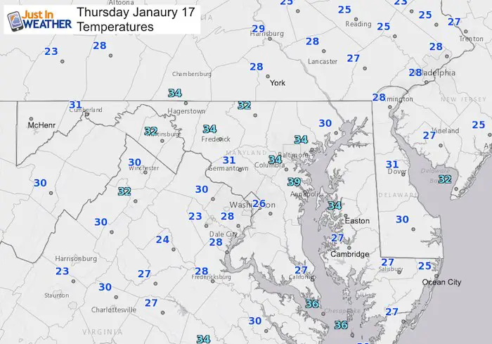
Morning Temps
Afternoon Temps
Some thawing and warming of road surfaces briefly….
Snow timelines
Thursday Evening —>slider
The first round is more likely between 6 and 9 PM to reach Northern Frederick, Carroll, Baltimore, Hartford, and Cecil Counties in Maryland. Also Southern PA.
[metaslider id=71094]
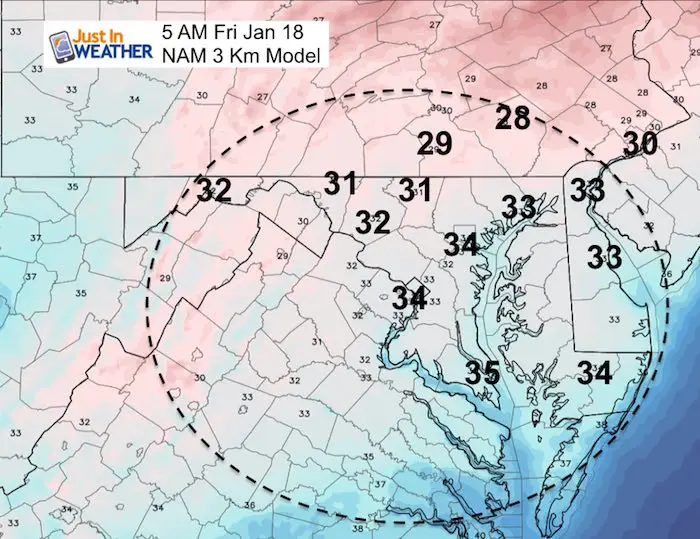
Thursday Overnight —>slider
The second push of snow seems faster on the NAM. This will be an overnight ‘thing’ and done before the morning commute.
Notice the Freezing line for most likely impact on the roads
[metaslider id=71105]
Snow Potential
NAM Model

NWS Baltimore Washington

Repeat Of My Call For Snowfall
These still are in agreement with the forecast I posted yesterday

Thursday Morning Temperatures
The freezing line and north is where the roads are likely to lead to some school delays. This is mainly in northern zones of Maryland and Southern PA
Jumping Ahead To The Weekend Storm
Storm Simualtion —> slider
The main issues:
- Saturday: Snow may begin late afternoon Evening.
- Sunday morning: Rain south, but north zones may stay icy longer
- Sunday afternoon/evening: Flash Freeze with arctic air
- Snow totals likely to be low. The important factor will be the quick freezing.
[metaslider id=71135]
Compare to this look at Sunday Evening
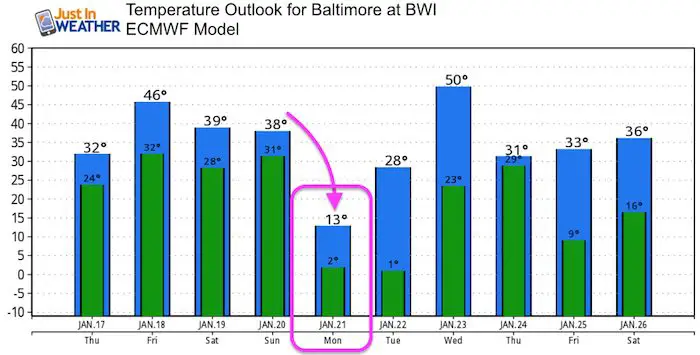
Temperature Outlook

We are giving 10% of each sale to Just In Power Kids: Providing FREE holistic care for pediatric oncology patients.
Maybe These Snow Day Kits Worked- Get in on the action
NEW: Individual Items Are Now Available A La Carte.

FITF and SnowStix Available NOW

Please share your thoughts, best weather pics/video, or just keep in touch via social media
-
Facebook: Justin Berk, Meteorologist
-
Twitter: @JustinWeather
-
Instagram: justinweather
Keep In Touch Every Day
Click here to sign up for email alerts…. Just in case you don’t get the post on your social media feed
Related Links:
Winter Outlook
My Winter Outlook 2018-19: Multiple Nor’Easters and more snow

Interactive Snow Report
November 15 Snow Reports- Interactive Map Compared To My Forecast

Winter Snow And Top 5 Wet Years
Snowfall Seasons at Beginning and End of Top 5 Wet Years In Baltimore

Related Winter Outlooks
Solar Cycle: When Sun Spots Are Low We Get More Snow
El Nino Modoki May Enhance Snow Chances
Sweet Spot: Hitting 70ºF on Halloween is followed by more winter snow
Will A Wet Summer Bring A Snowy Winter?
NOAA Winter 2018-2019 Outlook Explained: This Actually Supports Snow
Winter Outlook From Two Different Farmers Almanacs
Maryland Winters: Snowfall Maps and Baltimore Snow History
