January 16 2019
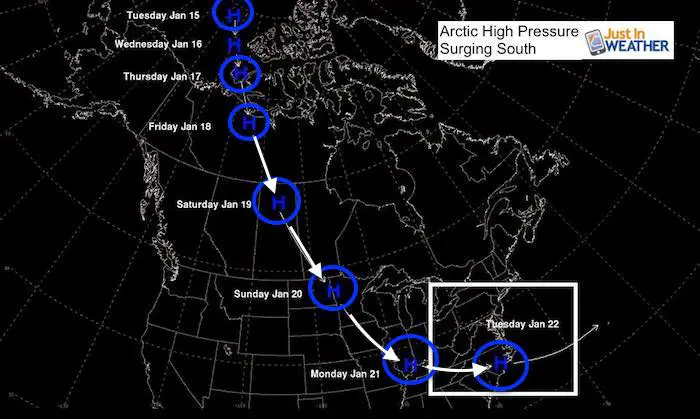
We have a very active and very complicated weather pattern over the next few days. Two weather systems will both bring a mix of snow, ice, and rain to our area. While this alone can be stressful for travel and plans, the arctic high pressure following the second storm is really going to make a abrupt drop in our temperatures. This is really going to bring an air mass from near the North Pole to North Carolina by early next week.
Details On Both Events
I wrote two posts this afternoon to highlight both weather systems. Considering the amount of messages I received asking questions about each storm, I realized that my afternoon updates may have not reached your newsfeed. So here is a recap and quick breakdown.
Please click on the images for the detailed report.
Event 1 Thursday Night/Friday Morning

- Thursday: Light snow or sleet showers afternoon. Impact marginal before 6 PM
- Thursday night: Snow north, mix to rain south. Impact increases after 8 PM.
- Snow will range up to an inch or two north, to just grass south of Baltimore.
- Classic icy areas will be near I-95 and north/west. City and south has a better chance to thaw by Friday morning.
Click here to see the snow/rain timeline
Event 2 Saturday Afternoon To Sunday Night

Flash Freeze!
Quick Cast Notes:
- Saturday afternoon or evening may bring in light snow or sleet at the start.
- Saturday night into Sunday morning change to rain from south to north.
- ICE may linger near the PA line or across southern PA. That extended icing is what the European Model shows. However the warming will be fighting north. We must consider more weight to the north push like last weekend’s event.
- Sunday afternoon and evening it will get cold. FAST! Change to snow, but amounts are not know. NO ONE knows how much we will get since the timing of the change over is up for debate.
- Sunday night and Monday morning the entire region will be in a deep freeze . The MLK holiday will be a break for schools, but anyone whoo has to work will feel the results.
Click here to see this full report
Getting Colder
This is just the beginning.
We are expecting the fractured Polar Vortex to unload even colder air before the end of January and into February.
My next update will be Thursday morning by 6:30 AM
Keep In Touch Every Day
Just in case you don’t get all posts on your social media feed, stay up to date with the latest info…
Click here to sign up for email alerts…. Be the first to hear any new weather forecasts

New Partner
Buchanan Kia of Westminster is a supporter of Just In Power Kids and Maryland Trek 6 in August 2019.

We are giving 10% of each sale to Just In Power Kids: Providing FREE holistic care for pediatric oncology patients.
Maybe These Snow Day Kits Worked- Get in on the action
NEW: Individual Items Are Now Available A La Carte.

FITF and SnowStix Available NOW

Please share your thoughts, best weather pics/video, or just keep in touch via social media
-
Facebook: Justin Berk, Meteorologist
-
Twitter: @JustinWeather
-
Instagram: justinweather
Keep In Touch Every Day
Click here to sign up for email alerts…. Just in case you don’t get the post on your social media feed
Related Links:
Winter Outlook
My Winter Outlook 2018-19: Multiple Nor’Easters and more snow

Interactive Snow Report
November 15 Snow Reports- Interactive Map Compared To My Forecast

Winter Snow And Top 5 Wet Years
Snowfall Seasons at Beginning and End of Top 5 Wet Years In Baltimore

Related Winter Outlooks
Solar Cycle: When Sun Spots Are Low We Get More Snow
El Nino Modoki May Enhance Snow Chances
Sweet Spot: Hitting 70ºF on Halloween is followed by more winter snow
Will A Wet Summer Bring A Snowy Winter?
NOAA Winter 2018-2019 Outlook Explained: This Actually Supports Snow
Winter Outlook From Two Different Farmers Almanacs
Maryland Winters: Snowfall Maps and Baltimore Snow History
