Wednesday January 16 2019
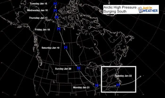
We are in the middle of what is normally the coldest part of winter, but this year we are just seeing the beginning. There are two weather systems on the way that will be followed by one arctic blast early next week. High Pressure is coming from the Arctic Circle to settle to our south and you will feel it! But that will be followed by the fractured Polar Vortex to end the month and make it more brutal cold at the end of January. That would be a headline itself.
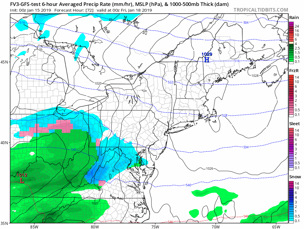
But before we can look that far ahead, we need to take a look at two weather events on the way. I have stayed away from the hype as the system appears to be inland and taking the rain line north. That means we will have snow and rain mixing at various times. Our northern areas will have some travel concerns Friday morning, but I think the more widespread potential icing will be at the end of the weekend region wide.
Quick Cast:
Event 1
- Today: Cold with increasing clouds
- Thursday: Light snow or sleet showers afternoon.
- Thursday night: Snow north, mix to rain south. Totals only about 1″
Event 2
- Saturday: Afternoon snow or mix
- Saturday night: Change to rain from south to north
- Sunday: Rain will ABRUPTLY turn to snow after noon. FLASH FREEZE likely on roads.
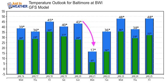
- Monday: Arctic Cold = Deep Freeze!
Local Weather Stats For January 16, 2019 in Baltimore
*Second day of Record Heat Wave for January*
Average High: 41ºF
Record High: 71ºF in 1953
Average Low: 24ºF
Record Low: 1ºF in 1893
*Record Snow: 7.0 in 1945
Sunrise: 7:24 AM
Sunset 5:08 PM
*Daylight = 1:28 longer than yesterday
*Bay Water Temperature = 37ºF at Thomas Pt. Light House

New Partner
Buchanan Kia of Westminster is a supporter of Just In Power Kids and Maryland Trek 6 in August 2019.
Keep In Touch Every Day
Just in case you don’t get all posts on your social media feed, stay up to date with the latest info…
Click here to sign up for email alerts…. Be the first to hear any new weather.
Morning Temps
Deep freeze and some icy spots this morning.

Afternoon Temps
We will thaw today, but more clouds afternoon will make it feel chilly.

Thursday Morning
Back into the freeze

Thursday Afternoon Snow/Sleet
The arrival of the next event may actually have some showers a few hours head… During the late afternoon. Please notice the freezing line is around I-95. So inland has a better chance for any problems.

Snow/Rain Simulation —> slider
Thursday night into Friday morning.
[metaslider id=70952]
Friday Morning Temperatures
The freezing zone will be near Baltimore and north/west. The snow will be light, but the frozen ground may add to stickage potential and slick road impacts for the morning commute.

Event 1 Animation
Thursday evening to Friday morning
Event 2
Saturday afternoon to Sunday Evening
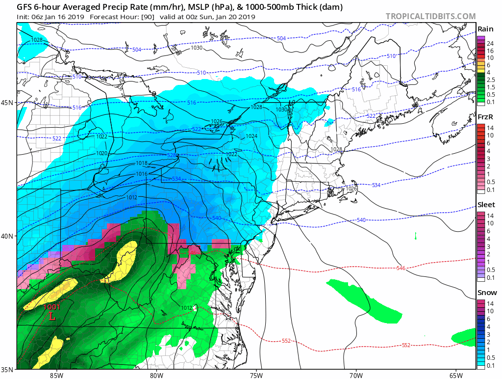
Event 2 Weekend Storm –> slider
[metaslider id=70973]
Snow Totals?
I will start posting a look at that tomorrow. It is not only earlier than I usually do, but the higher totals will be to the north. I think the main issue will be the abrupt drop in temperatures and flash freeze.
Arctic Cold Surge
Behind the weekend event, Monday temps will likely remain in the teens or colder.
Notice the mild trend mid week. That is just as the atmosphere relaxes ahead of the next big change and the fractured Polar Vortex.
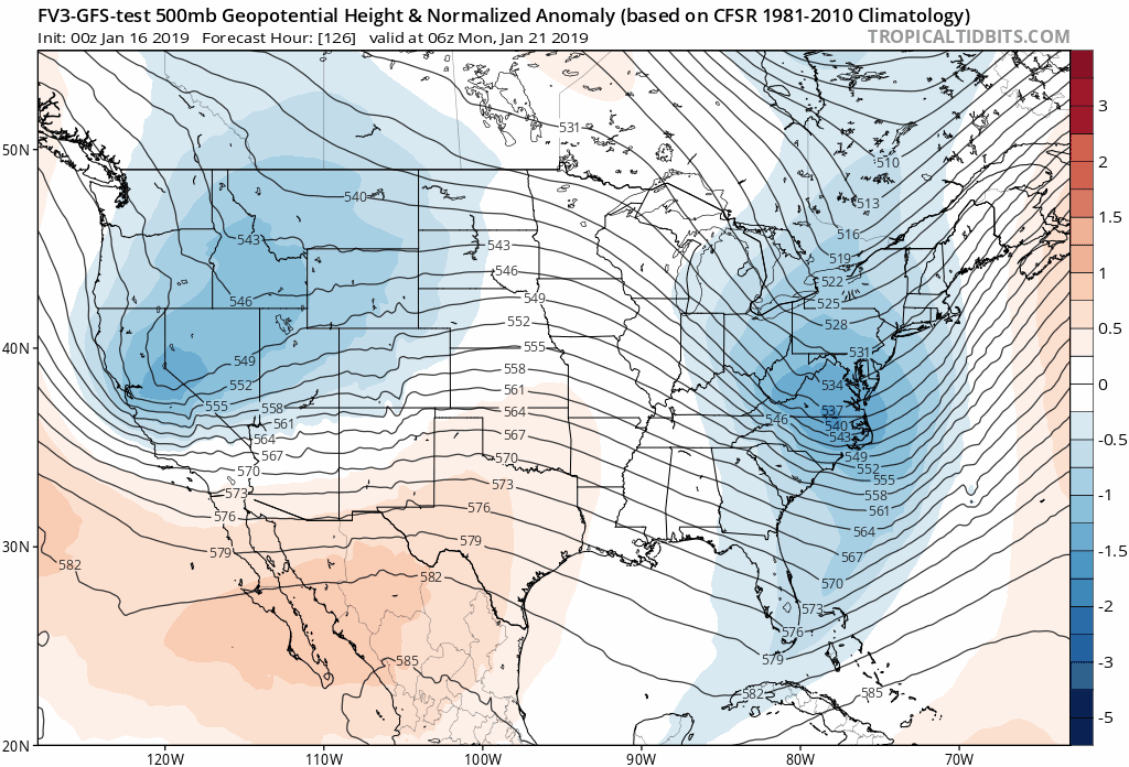
Long Range Outlook
This upper level animation shows the jet stream. The blue shading is where the cold arctic air settles in. As you can see, the last few images the Polar Vortex drops south and cold air invades the entire eastern US

We are giving 10% of each sale to Just In Power Kids: Providing FREE holistic care for pediatric oncology patients.
Maybe These Snow Day Kits Worked- Get in on the action
NEW: Individual Items Are Now Available A La Carte.

FITF and SnowStix Available NOW

Keep In Touch Every Day
Just in case you don’t get all posts on your social media feed, stay up to date with the latest info…
Click here to sign up for email alerts…. Be the first to hear any new weather forecasts
Please share your thoughts, best weather pics/video, or just keep in touch via social media
-
Facebook: Justin Berk, Meteorologist
-
Twitter: @JustinWeather
-
Instagram: justinweather
Keep In Touch Every Day
Click here to sign up for email alerts…. Just in case you don’t get the post on your social media feed
Related Links:
Winter Outlook
My Winter Outlook 2018-19: Multiple Nor’Easters and more snow

Interactive Snow Report
November 15 Snow Reports- Interactive Map Compared To My Forecast

Winter Snow And Top 5 Wet Years
Snowfall Seasons at Beginning and End of Top 5 Wet Years In Baltimore

Related Winter Outlooks
Solar Cycle: When Sun Spots Are Low We Get More Snow
El Nino Modoki May Enhance Snow Chances
Sweet Spot: Hitting 70ºF on Halloween is followed by more winter snow
Will A Wet Summer Bring A Snowy Winter?
NOAA Winter 2018-2019 Outlook Explained: This Actually Supports Snow
Winter Outlook From Two Different Farmers Almanacs
Maryland Winters: Snowfall Maps and Baltimore Snow History
