Wednesday January 16 2019
There are two winter events on the way and both will be a mix of snow and rain across our region. The first system will arrive with some showers Thursday afternoon, but the bulk of the snow and ice will fall overnight. Since the freezing line will be split across our area, this is where we break out the geography and point to the normally colder inland areas west and north of I-95 for the likely impact Friday morning.
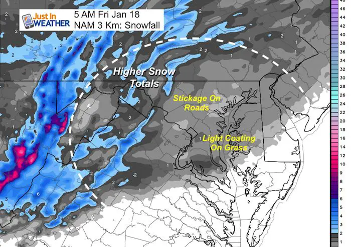
The timelines below should help to reinforce what I am thinking. You will find two sliders separating Thursday and Friday radar simulations. Also look at the temperate on Friday morning, then compare the NAM Model snow map to my call for snowfall.
As for the second event this looks like rain for most Saturday night ending as snow Sunday with an abrupt cool down and flash freeze. I will get into more on that system in my next report.
Thursday Radar Simulation –> slider
Showers may mix with sleet between 4 and 7 PM. Steadier snow will develop west and north of the cities but spread across the cities at night.
Evening Activities may need a last moment adjustment. The spread of early showers and any stickage before 8 PM Thursday is marginal. After that travel will be getting slippery in the snow zone.
The Freezing Line in purple is the best indication of possible road impact. Otherwise snow may stick in warmer areas just on the grass.
[metaslider id=71034]
Friday Morning Radar Simulation –> slider
[metaslider id=71051]
Temperatures Friday Morning

NAM Model Snowfall
My Call For Snowfall and Impact

Notes: This may be the classic set up for impact on roads in the normally colder zones west and north of the main cities. I-95 is often the dividing line for freezing temperatures. As of now it appears there will be minimal to no impact in Southern Maryland.
The weekend appears to keep the blockbuster storm just north with central PA to New England in the heavy snow range. I will have more on that next.
Keep In Touch Every Day
Just in case you don’t get all posts on your social media feed, stay up to date with the latest info…
Click here to sign up for email alerts…. Be the first to hear any new weather forecasts

New Partner
Buchanan Kia of Westminster is a supporter of Just In Power Kids and Maryland Trek 6 in August 2019.

We are giving 10% of each sale to Just In Power Kids: Providing FREE holistic care for pediatric oncology patients.
Maybe These Snow Day Kits Worked- Get in on the action
NEW: Individual Items Are Now Available A La Carte.

FITF and SnowStix Available NOW

Please share your thoughts, best weather pics/video, or just keep in touch via social media
-
Facebook: Justin Berk, Meteorologist
-
Twitter: @JustinWeather
-
Instagram: justinweather
Keep In Touch Every Day
Click here to sign up for email alerts…. Just in case you don’t get the post on your social media feed
Related Links:
Winter Outlook
My Winter Outlook 2018-19: Multiple Nor’Easters and more snow

Interactive Snow Report
November 15 Snow Reports- Interactive Map Compared To My Forecast

Winter Snow And Top 5 Wet Years
Snowfall Seasons at Beginning and End of Top 5 Wet Years In Baltimore

Related Winter Outlooks
Solar Cycle: When Sun Spots Are Low We Get More Snow
El Nino Modoki May Enhance Snow Chances
Sweet Spot: Hitting 70ºF on Halloween is followed by more winter snow
Will A Wet Summer Bring A Snowy Winter?
NOAA Winter 2018-2019 Outlook Explained: This Actually Supports Snow
Winter Outlook From Two Different Farmers Almanacs
Maryland Winters: Snowfall Maps and Baltimore Snow History
