Tuesday January 15 2019
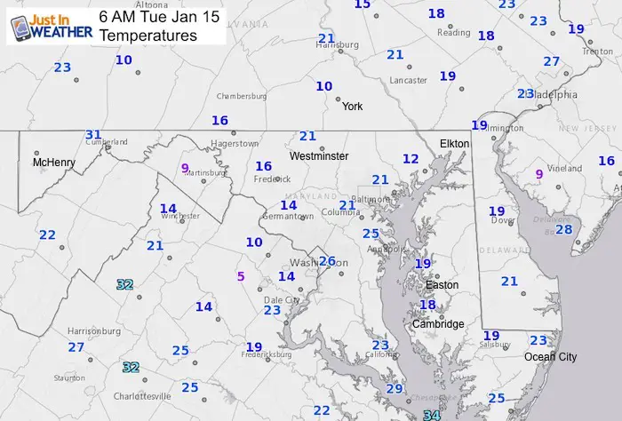
Before we jump ahead to the next two storms, our recent snow is still effecting the region. The refreeze overnight led to a lot of ice and many school delays in central and southern Maryland this morning. This includes Howard and Anne Arundel Counties. Temperatures are down in the teens and lower 20s in many areas. We will warm above freezing today, but it will take a few hours to thaw again.
The next two storms are a bit more complicated and why I did not want to pounce earlier. If you missed my thoughts on them in yesterday’s report, I know it was buried with a lot of other data. If you did not see my post on Facebook last night, that proves they are not showing everything I write to you. Please sign up for my newsletter. Here I will spend more time showing how I think this will play out. Initial models with strong storms often have a bias and like the last storm verify farther north. It still will impact travel, but not be an all out snow storm.
Morning Temperatures
Please note that there has been a ice reported on roads across central and Southern Maryland where some of the heaviest snow fell. There are many schools delayed, but regular commuting may be slowed by accidents. Temps are cold and you may feel it more today with a developing breeze. This may help hint at how to dress.
Winter Weather Quick-Cast:
Storm 1
- Today: Freezing morning, slow thaw this afternoon
- Thursday: Light snow possibly in the evening
- Thursday night: Turning to rain south to north
- Friday morning: Storm ends as rain.
Storm 2
- Saturday Evening/Night: Light snow or rain
- Sunday Morning: Heavy rain, warmer
- Sunday Afternoon: Changing to snow. May be heavy for a few hours
- Sunday Night: Freezing and icing up, even across Delmarva
Local Weather Stats For January 15, 2019 in Baltimore
*Second day of Record Heat Wave for January*
Average High: 41ºF
Record High: 78ºF in 1932
Average Low: 24ºF
Record Low: -2ºF in 1964
*Record Snow: 3.4 in 1957
Sunrise: 7:24 AM
Sunset 5:07 PM
*Daylight = 1:26 longer than yesterday
*Bay Water Temperature = 38ºF at Thomas Pt. Light House
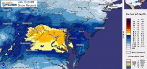
Also see: Final Snow Report Fro Jan 13 And Seen From Space

New Partner
Buchanan Kia of Westminster is a supporter of Just In Power Kids and Maryland Trek 6 in August 2019.
Keep In Touch Every Day
Just in case you don’t get all posts on your social media feed, stay up to date with the latest info…
Click here to sign up for email alerts…. Be the first to hear any new weather forecasts
Afternoon Highs
*Note: Refreezing will take place around sunset. Most areas drop back to the 20s before Wednesday morning

Looking Ahead
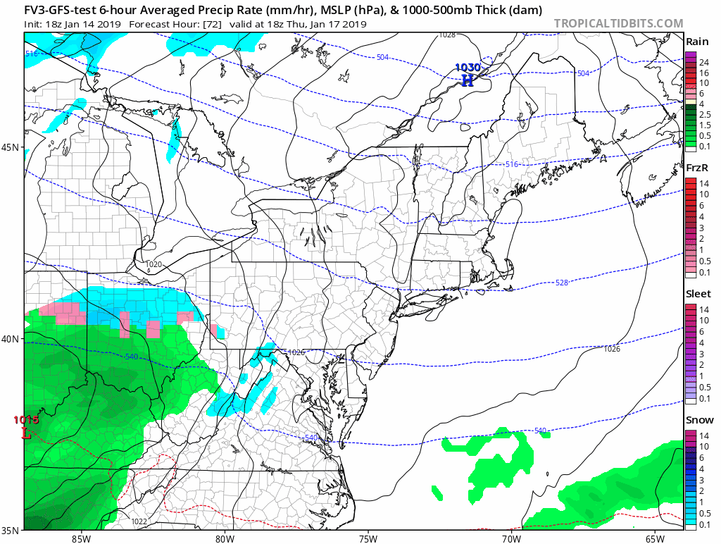
Storm 1: Thursday Night/Friday
- Thursday: Light snow possibly in the evening
- Thursday night: Turning to rain south to north
- Friday morning: Storm ends as rain.
Radar Simulation –> slider
[metaslider id=70932]
Storm Animation
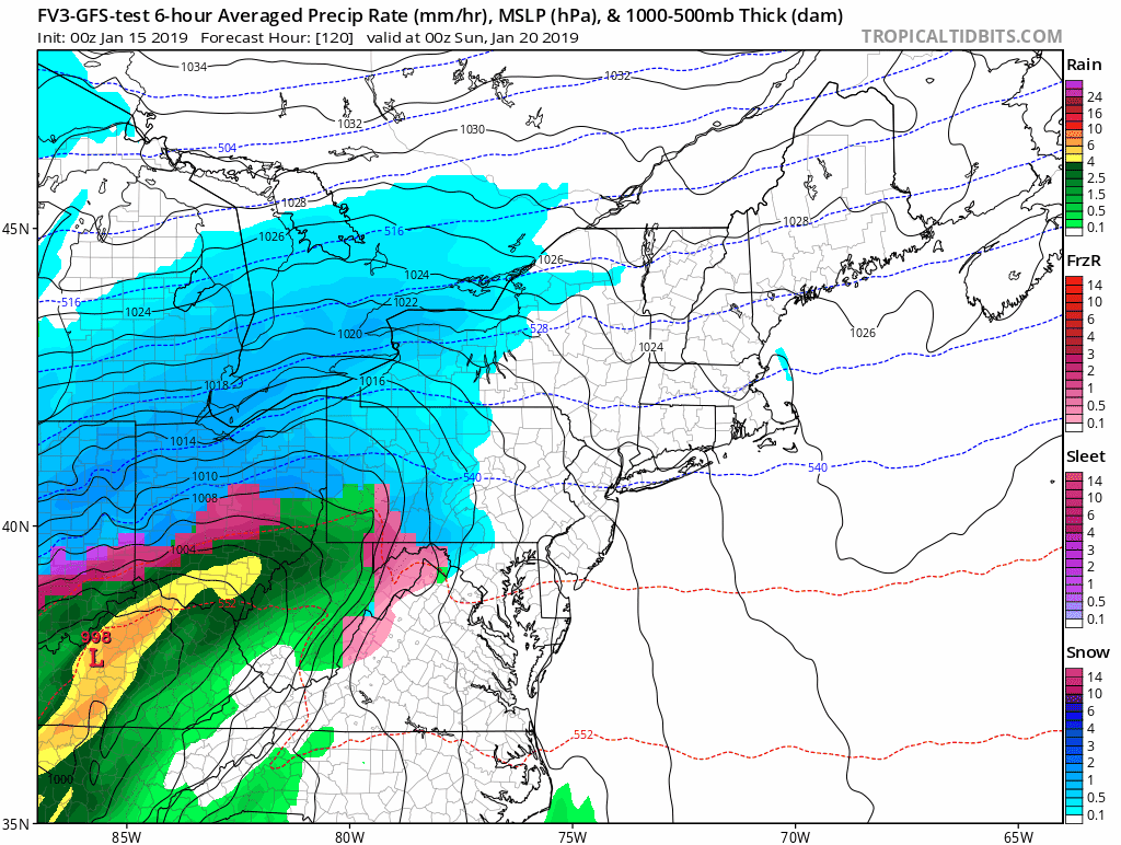
Storm 2 Saturday/Sunday
- Saturday Evening/Night: Light snow or rain
- Sunday Morning: Heavy rain, warmer
- Sunday Afternoon: Changing to snow. May be heavy for a few hours
- Sunday Night: Freezing and icing up, even across Delmarva
This has a lot of agreement. Here is a look at the European Model Track
Storm Simulation —> slider
[metaslider id=70920]
Storm Animation
It is likely that we have travel impact Sunday afternoon and night. Then a hard freeze and ice into Monday morning after the storm.
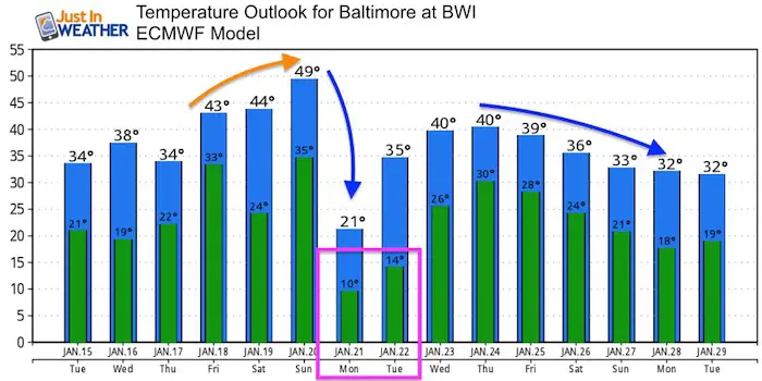
Temperature Outlook
The warming spikes are reflective of storms that may stay inland. But we will have more cold air. The pattern and potential Polar Vortex dropping towards the Northern US is still on target for the end of January.

We are giving 10% of each sale to Just In Power Kids: Providing FREE holistic care for pediatric oncology patients.
Maybe These Snow Day Kits Worked- Get in on the action
NEW: Individual Items Are Now Available A La Carte.

FITF and SnowStix Available NOW

Keep In Touch Every Day
Just in case you don’t get all posts on your social media feed, stay up to date with the latest info…
Click here to sign up for email alerts…. Be the first to hear any new weather forecasts
Please share your thoughts, best weather pics/video, or just keep in touch via social media
-
Facebook: Justin Berk, Meteorologist
-
Twitter: @JustinWeather
-
Instagram: justinweather
Keep In Touch Every Day
Click here to sign up for email alerts…. Just in case you don’t get the post on your social media feed
Related Links:
Winter Outlook
My Winter Outlook 2018-19: Multiple Nor’Easters and more snow

Interactive Snow Report
November 15 Snow Reports- Interactive Map Compared To My Forecast

Winter Snow And Top 5 Wet Years
Snowfall Seasons at Beginning and End of Top 5 Wet Years In Baltimore

Related Winter Outlooks
Solar Cycle: When Sun Spots Are Low We Get More Snow
El Nino Modoki May Enhance Snow Chances
Sweet Spot: Hitting 70ºF on Halloween is followed by more winter snow
Will A Wet Summer Bring A Snowy Winter?
NOAA Winter 2018-2019 Outlook Explained: This Actually Supports Snow
Winter Outlook From Two Different Farmers Almanacs
Maryland Winters: Snowfall Maps and Baltimore Snow History
